
Why is the weather so volatile in eastern Australia this week?
Severe thunderstorms, extreme heat, damaging winds and catastrophic fire danger ratings are affecting eastern Australia this week. So, why is the weather so active and when will things calm down?
Ongoing severe storm outbreak
Severe thunderstorms have been a daily feature over eastern Australia since late last week under the influence of lingering warm and humid air and copious atmospheric instability.
Both Queensland and New South Wales have been impacted by this severe storm outbreak, with beastly supercells dumping giant hail in southeast Qld on both Sunday and Monday.

Image: Hail that fell at Loganholme, Qld on Sunday, November 23. Source: @earthly.emma / Instagram
On Tuesday, thunderstorms stretched more than 2,000 km from the Hunter in NSW up to far northern Qld, including yet another band of storms that passed over Brisbane on Tuesday night.
Millions of lightning pulses have been detected over eastern Australia in the last few days, including about 950,000 pulses withing 200 km of Brisbane between Sunday morning and Wednesday morning.
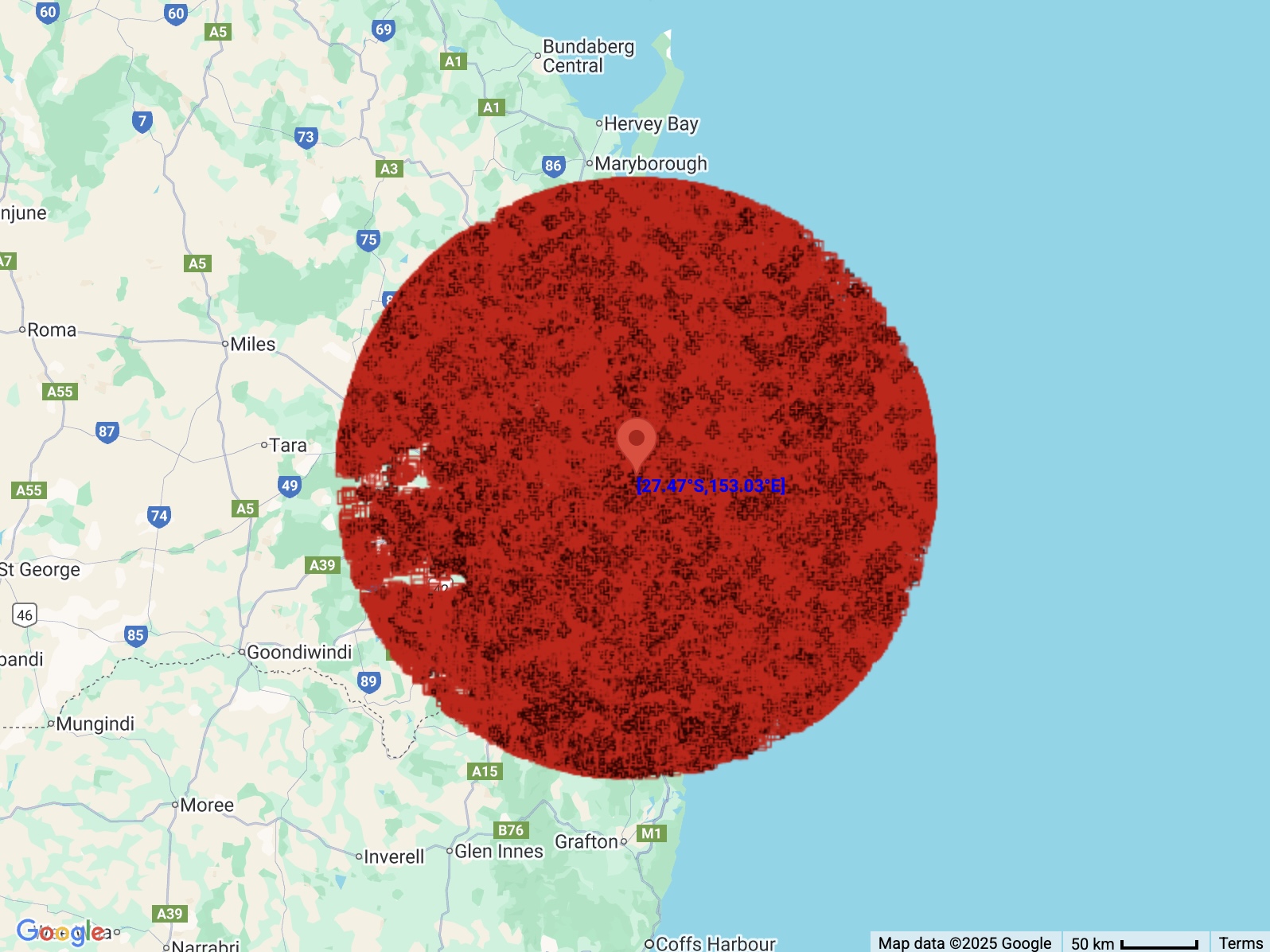
Image: Red symbols show the locations of lightning pulses detected within a 200 km radius of Brisbane between 9am AEST on Sunday, November 23 and 9am AEST on Wednesday, November 26. Source: Weatherzone.
Severe thunderstorms mostly targeted NSW up until the early afternoon on Wednesday. These storms caused hail and wind gusts exceeding 100 km/h in parts of the state’s Central West. The storms then spread further east, prompting warnings for damaging winds and large hail in parts of Sydney, the Illawarra and the Central Coast.
Oppressive heat
One of the key ingredient’s driving this week’s volatile weather has been hot air spreading from central Australia across Qld and NSW.
This outback heat, which was intensified by Tropical Cyclone Fina passing over northern Australia late last week, has caused temperatures to reach the low to mid-forties in parts of Qld and NSW every day since Sunday.
Sydney felt the influence of this hot and humid air on Wednesday, with the mercury exceeding 34°C by midday before storms cooled the city by around 10°C in the early afternoon.
Wind and fire danger
Some of this week’s thunderstorms have caused damaging wind gusts. On Wednesday, gusts reached 111 km/h at Trangie, 110 km/h at Orange and 109 km/h at Dubbo around midday as severe storms roared over Central West NSW.
Wind has also been blustery independent of storms this week due to steep pressure gradients associated with low pressure troughs. A severe weather warning was issued for damaging winds over southern and central parts of NSW on Wednesday.
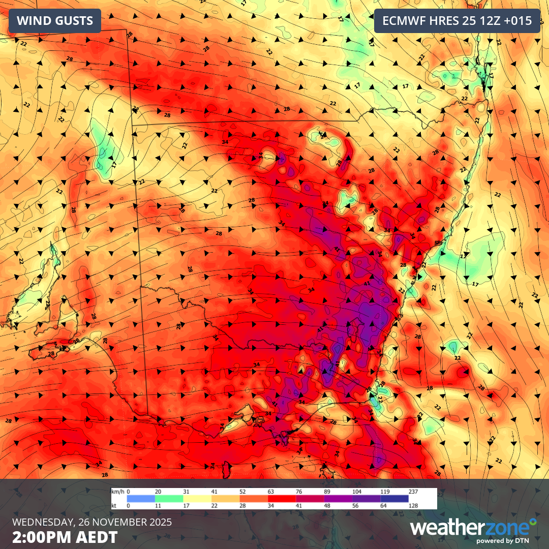
Image: Forecast wind gusts over Australia’s southeast mainland on Wednesday afternoon. Source: Weatherzone.
Wednesday’s wind combined with high temperatures to create Extreme to Catastrophic fire danger ratings in parts of NSW. This was the first time in two years a Catastrophic rating had been forecast in NSW.
When will the weather calm down?
Most of NSW will see calmer weather on Thursday as thunderstorms contract to Qld and parts of central and northern Australia.
A cold front passing over southern Australia later in the week will cause showers and storms to once again become more widespread, with storms likely to impact parts of every mainland state and territory between Friday and Sunday.
Looking further ahead, next week looks less stormy for much of the country, although a series of cold fronts will cause a brief burst of cold, wet and windy weather in southeastern Australia on Sunday and Monday. There could even be some snow in parts of NSW, Vic and Tas on the first day of summer.