
What caused Monday’s giant hailstones over Brisbane?
Thousands of residents of southeast Queensland were still without power early on Tuesday morning, with some people waking up to worse damage than that inflicted by Cyclone Alfred in March, after relatively brief but severe hailstorms struck late on Monday afternoon.
An outbreak of thunderstorms formed over far northeastern New South Wales on Monday and rapidly crossed the border, impacting areas along the coast and nearby hinterland and ranges from the Gold Coast to Bundaberg.
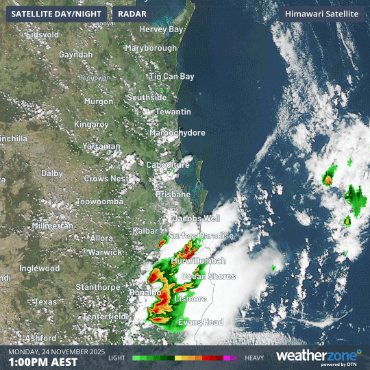
Image: Four-hour loop showing radar and water vapour in the atmosphere from 1pm to 5pm in SE Qld and far NE NSW (AEST) on Monday, 24 November, 2025.
Some of the noteworthy rainfall totals (all of which fell in a brief period of around an hour or less) included:
- 79mm at Moreton Island
- 69mm at Upper Rous River/Hopkins Creek (on the NSW side of the border, just south of Lamington NP)
- 56mm at Hervey Bay
- 40.6mm at Maryborough
- 34.8mm at Tewantin
- 31.6mm at Brisbane Airport
- 29.4mm at Brisbane
Some of the largest hailstones observed included:
- 14cm hailstones near Chandler around 3:00pm
- 11cm hailstones at Manly, Ferny Hills and Alexandra Hills around 3:30pm
- 9cm hailstones at Bunya around 3.24pm
- 9cm hailstones at Coombabah, Gold Coast, at 2:10pm
Wind gusts exceeding 100 km/h were also reported during the storms in SE Qld, including at Brisbane Airport and on the Sunshine Coast.
How did the storms form?
As Weatherzone meteorologist Ben Domensino wrote on Monday morning when discussing the potential for violent SE Queensland thunderstorms on Monday afternoon, the three main ingredients for thunderstorms – instability, moisture and a trigger (or triggers) – were all in place.
Atmospheric instability was abundant over the affected area due to warm air near the surface and much cooler, drier air aloft. This instability provided the lift required to build large thunderstorm clouds stretching thousands of metres into the sky.
Abundant moisture was available in the lower and middle levels of the atmosphere, providing ample fuel for storm clouds to become loaded with rain and hail.
As for the third element, there were two main triggers. The first was a "dry line" sitting over southeast Qld and northeast NSW – a zone where moisture-laden air to the east clashed with drier air to the west. The second trigger was a southeasterly change moving north throughout the afternoon and evening.
Why was the hail so large?
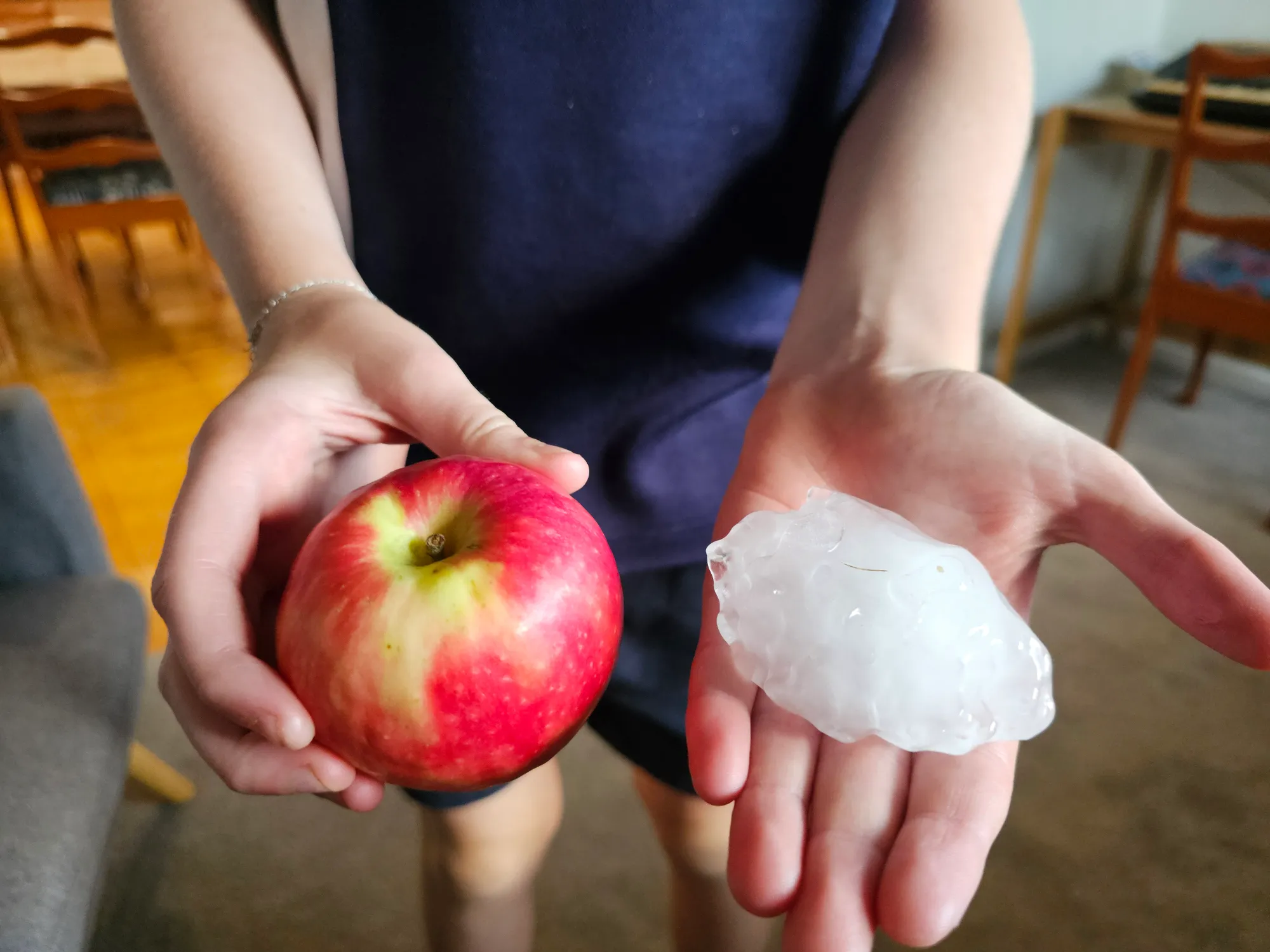
Image: Hailstones the size of apples fell in The Gap, Brisbane, on November 24, 2025. Source: Nick Gilpin (@nickgilpin) on Threads.
Hail forms when raindrops are carried high into the sky by a thunderstorm’s updraft. The hail grows larger when it collides with supercooled water droplets high in the storm cloud, which freeze onto the surface of the hailstone and make it grow.
Stronger thunderstorms have powerful updrafts that cause hailstones to rise and fall over and over, accumulating new layers of ice each time they lift into the cold upper-levels of the storm (that’s why you often see layers on a large hailstone resembling the rings inside an onion).
As mentioned above, all of the elements were in place for the development of severe thunderstorms, which meant the atmosphere was like a natural laboratory for the creation of giant hailstones.
This image shows yesterday’s storm crossing Bribie Island.
— David Crisafulli (@DavidCrisafulli) November 24, 2025
The cell produced more than 800,000 lightning strikes and 100km/h winds, leaving a trail of destruction across the south east of our State.
We’re working hard to deliver assistance to Queenslanders who need it.
⚡️ For… pic.twitter.com/CLm4r44TDf
What next for Brisbane and SEQ weather?
Afternoon or evening showers and thunderstorms are possible over the next three days from this Tuesday through to Thursday. The storms may be severe.
Days will be hot, sticky and uncomfortable right across southeast Qld, with maximums in the low-to-mid thirties across the region. Inland temperatures will be a few degrees higher than those along the coast.