
Hottest October on record in Queensland, Northern Territory
Australia has registered its third-warmest October since national records were first kept in 1910, with Queensland and the Northern Territory recording their hottest Octobers on record.
Seven of the eight Australian states and territories recorded average statewide temperatures that were at least two degrees above the long-term monthly average in October 2025, while Tasmania was an outlier at almost half a degree below average.
We’ll break down why Tasmania was the only state which was much cooler than usual in October 2025 while the mainland was significantly warmer than average. But first, here are the raw statistics.
- AUSTRALIA AS A WHOLE: +2.51°C above average (the third warmest October)
- Queensland: +3.29°C (warmest on record, previous high anomaly 2.77°C in 2024)
- Northern Territory: +2.82°C (warmest on record, previous high anomaly +2.50 in 1988)
- New South Wales (including ACT): +2.61°C (3rd-warmest on record)
- South Australia: +2.43°C (5th-warmest on record)
- Western Australia: +2.04°C (7th-warmest on record)
- Victoria: +0.71°C
- Tasmania: -0.48°C
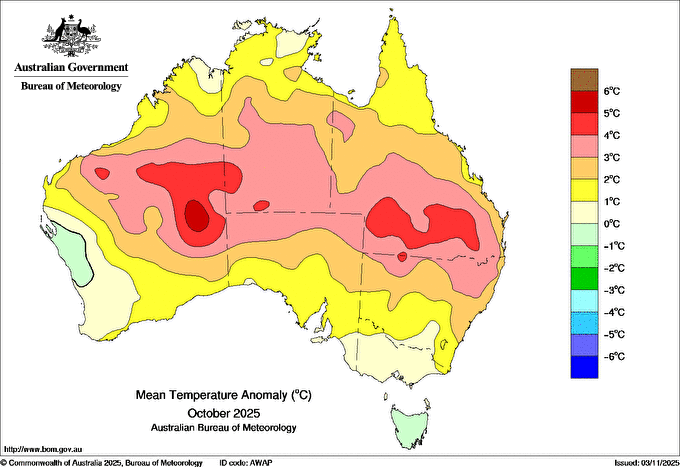
Image: Temerature anomalies across Australia in October 2025, with a clear pattern of warmer-than-average temperatures nationwide with the exception of Tasmania and a relatively small part of WA. Source: BoM.
Why was October 2025 so warm everywhere except Tasmania?
The overall pattern of warmth across mainland Australia reflects the underlying influence of climate change, but other factors were at play in the contrast between the mainland warmth and the relatively cool weather in Tasmania in October 2025.
The sudden stratospheric warming event
In late September, Weatherzone meteorologist Ben Domensino noted that a stratospheric warming event above Antarctica had weakened the polar vortex – a large rotating column of cold air surrounded by powerful winds which develops above Earth’s polar regions during the cooler months of the year.
“When stratospheric warming causes the tropospheric polar vortex to weaken, we usually see the polar jet stream become wavier and expand towards the equator which allows nodes of cold air to spread away from the polar region into the mid-latitudes," Domensino wrote.
Those nodes of cold air took the shape of a series of cold fronts and associated low pressure systems, which coated Tasmania in unseasonable snowfalls.
For the first time since March 2025, the Southern Annular Mode (SAM) spent more than a few days in negative territory (cold fronts tend to push northwards towards Australia more often during a negative phase of the SAM).
But while Tasmania shivered, many areas north of Victoria and the far southeast of SA started to bake.
Because air naturally flows from high pressure systems towards low pressure systems, heat from Australia’s interior was pushed to the southeast of the continent as the Southern Ocean lows roared their way across Tasmanian waters.
This created unseasonably warm conditions on parts of the southeastern mainland, and it's why places like Sydney and Brisbane had their warmest Octobers on record.
The mid-October outback hot air pool
Another reason for monthly temperatures being well above average on the mainland during October 2025 – and especially in outback parts of Qld, SA, NSW and the NT – was the large pool of extremely hot air which built up over the northwest of WA mid-month, then slowly drifted across the country in a southeasterly direction.
This scorching airmass caused the hottest October days on record in Qld and NSW, with October heat records broken at numerous individual weather stations in three states.
What about rainfall in October?
Rainfall was very close to average in October for Australia as a whole, with nationwide rainfall 2% above the long-term average. There were, however, significant differences between the states, with New South Wales receiving significantly less than its usual October rainfall.
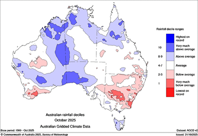
Image: Red zones in NSW indicate that it was the driest state by far in October 2025 in terms of its rainfall deficiency. Source: BoM.