
Hope on the horizon as snowless school holidays approach
The school holidays start at the end of the week for Victoria and Queensland, but people heading to the mountains will find almost no snow in what is already one of the worst starts to the Australian snow season on record.
The official snow depth at Spencers Creek – the highest of three New South Wales sites where Snowy Hydro regularly measures snow throughout the cooler months – is currently zero.
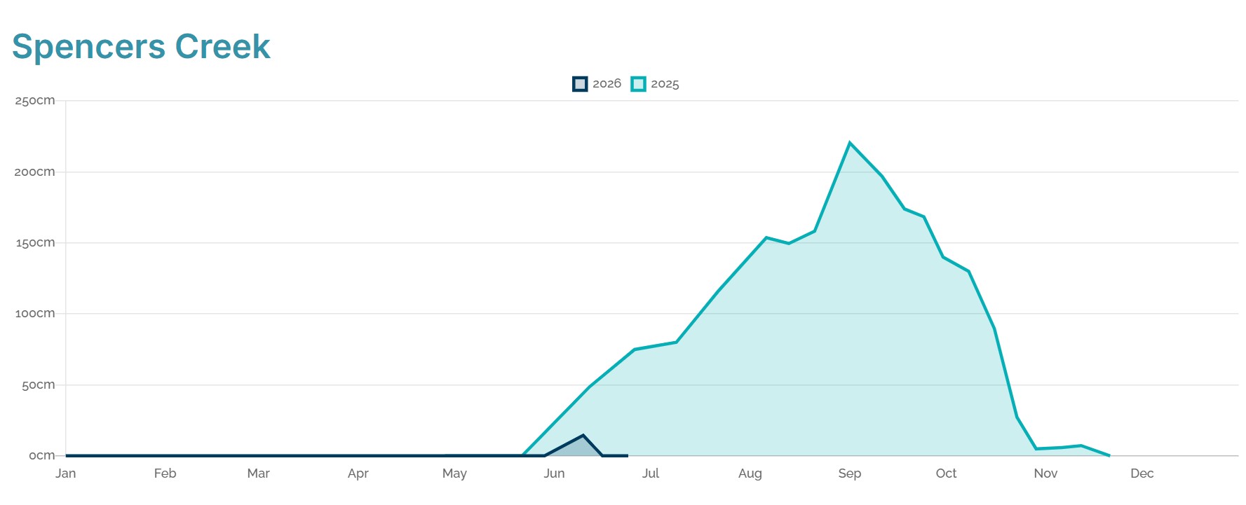
Image: Comparison of the 2025 snow season and the 2026 snow season to date at Spencers Creek, NSW. Source: Snowy Hydro.
Only once previously, in data going back to 1954, has Spencers Creek registered a snowless reading in July.
But that’s the scenario facing Australia’s snowfields with just a few days left in June 2026, with no fresh snowfalls expected before the end of the month.
The 2026 season so far: too wet, too warm for natural snow
June 2026 has not been a good month for Australian snow enthusiasts.
A minor snowfall just before the traditional King’s Birthday long weekend early in the month brought a reading of 14.4 centimetres at Spencers Creek on June 10. But that snow has since melted or been washed away by rain in unseasonably warm temperatures.
Across southeastern Australia and the Australian Alps this June, both maximum and minimum temperatures have averaged around 2-3°C above the long-term June average.
For example, the average daily maximum at Victoria’s highest ski resort Mt Hotham has been 3.5°C to date in June 2026. That might sound chilly, but the long-term June average is 1.5°C.
Too warm even for snowmaking
Compounding the frustration for our ski resorts and their visitors is that nights have generally been too warm for snowmaking.
Even this week, with the mercury falling below zero for at least four consecutive nights at alpine resorts like Perisher (NSW) and Falls Creek (Vic), the atmosphere has been a little too humid to fire up the snow guns with effect.
As we explained recently in our story on how snowmaking works, cold nights aren’t the only part of the snowmaking equation. When humidity is high and the air is saturated, the tiny droplets of water sprayed out by snow guns won’t freeze even if the temperature is slightly below zero.
READ MORE: Snowmaking begins in Australia: but how does it work?
Quite simply, there have been too few influxes of cool air from the Southern Ocean to produce snowfalls or even suitable conditions for snowmaking across Australia’s alpine region during June.
This has been due largely to blocking high pressure systems forcing the band of westerlies and their snow-producing cold fronts further south than usual – a typical set-up when we are in a positive phase of the Southern Annular Mode (SAM).
READ MORE: Strongest positive SAM in three years – what does this mean for Australia's weather?
Are any lifts open in Australian ski resorts now?
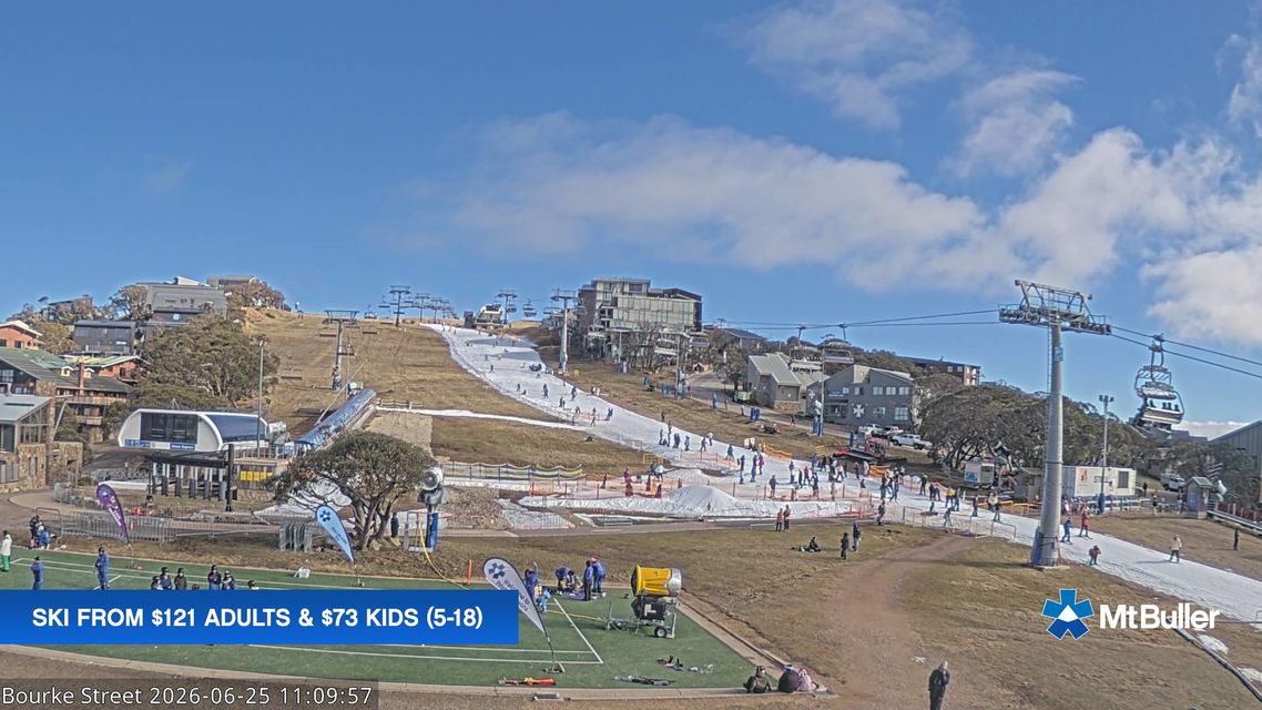
Image: A very popular strip of "snow" created by an ice factory snowmaking system. Source: Mtbuller.com.au.
There’s a ski lift or two open on the beginner runs at Thredbo (NSW), Perisher (NSW) and Mt Buller (Vic) but that’s about it.
Mt Buller and Thredbo have both benefited from a new type of snowmaking infrastructure generally called "ice factory" snowmaking or "all-weather" snowmaking.
Instead of spraying out a mixture of compressed air and water into the freezing night air, you make crushed ice inside a giant refrigerated unit that looks like a shipping container, then spread it out onto the slopes through a hose.
Technically it’s ice, not snow, but its texture is almost indistinguishable from natural or snowmaking snow once numerous skis or snowboards have slid across it.
When is a significant snowfall likely to arrive?
The good news is that models are starting to align towards the probability of a snowy system arriving a few days into July.
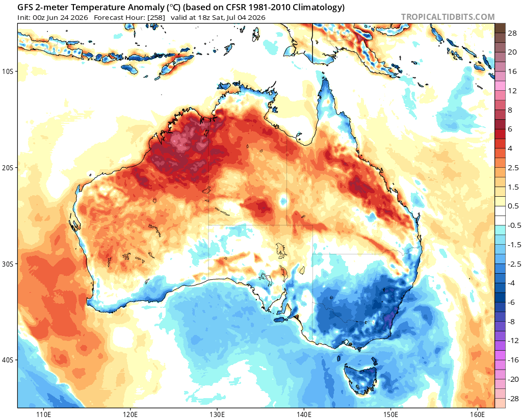
Image: Long-range temperature anomalies forecast for Australia on Saturday, July 4, 2026. Source: Tropical Tidbits.
As the image above shows, temperatures will at last be below average across southeastern Australia by about July 4, after weeks when that part of the country was consistently red (warmer than usual) most days and nights.
That’s a pointer to the coming snowy system, although how much moisture is associated with the potential cold outbreak remains to be seen.
But for the next week or so, the picture remains bleak, and indeed yet more rain will be a feature of the weather in the alpine area in coming days. If you’re heading to the “snow”, pack the hiking boots and a raincoat too.
Please check the Weatherzone snow page for the latest forecasts, live snow cams and more.