
Two weeks of widespread winter warmth across SE Australia
An unseasonable weather pattern has dominated the first half of June across southeastern Australia, with average temperatures much closer to late autumn than early winter.
All five southeastern capitals (Sydney, Melbourne, Adelaide, Hobart, Canberra) are currently tracking at well over two degrees above their average maximum and minimum temperatures – and it’s more than three degrees with both Sydney and Melbourne.
In fact, Melbourne just registered its warmest June night in well over a century of records, with a very mild overnight low of 16.4°C (the old record was 16.1°C).
Why has June 2026 been so warm to date in the southeast?
There have been two main reasons for the unusually warm conditions by June standards in the most populated part of the country.
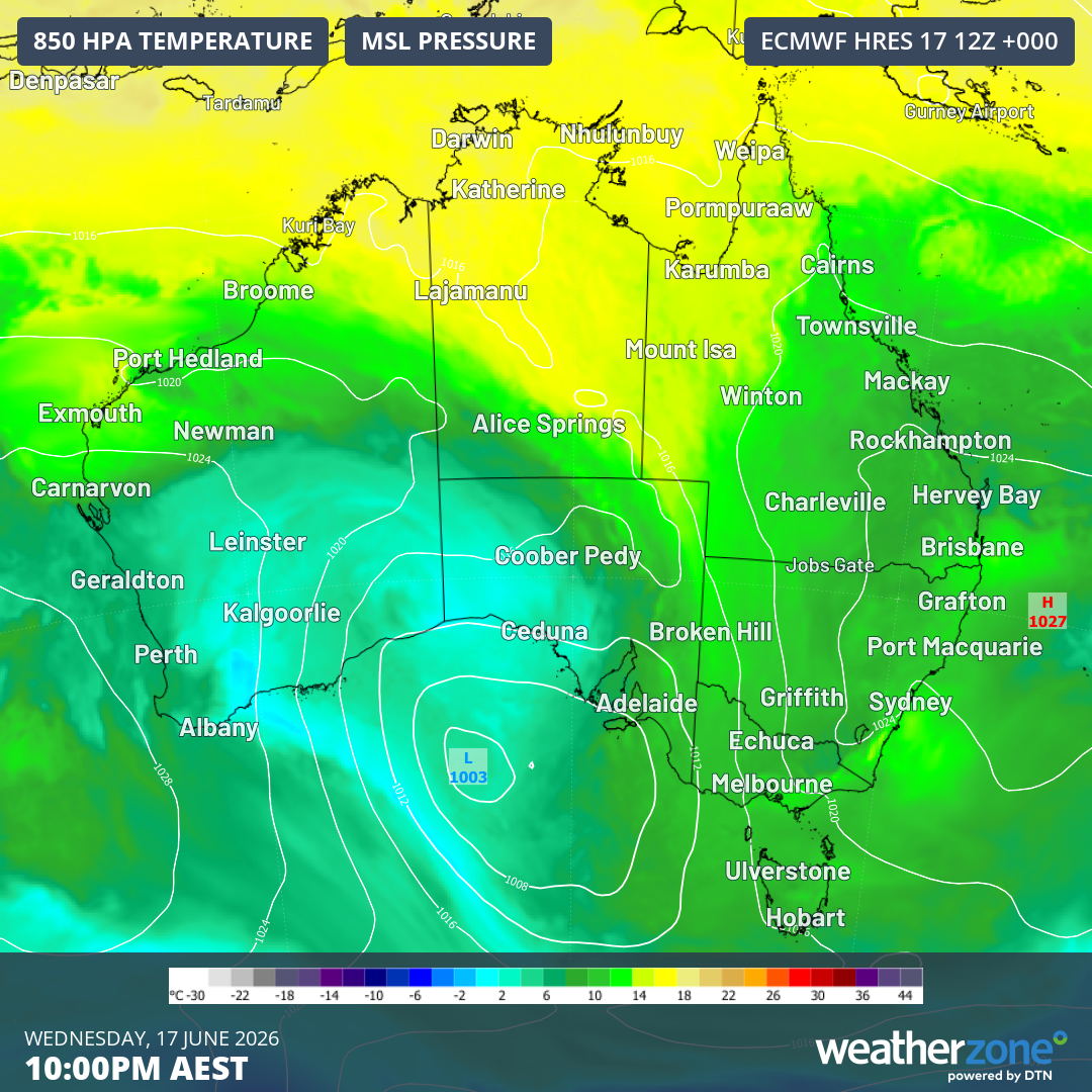
Image: Mean sea level pressure in Australia on Wednesday, June 17, 2026, showing the high pressure system which has dominated SE Australia’s weather all week finally starting to push out into the Tasman Sea. Source: Weatherzone.
- A persistent ridge of high pressure situated further south than usual for this time of year has blocked significant outbreaks of polar air from reaching southern Australia, apart from one brief system in the first few days of June.
- The position of the highs has enabled air with tropical origins to stream southwards from the Indian Ocean, with a series of northwest cloudbands crossing the country.
The good news about the northwest cloudbands is that they have delivered welcome rain to many areas – although the rain has been not so welcome in the snowfields, where temperatures have been several degrees too mild for natural snowfalls and for overnight snowmaking.
It’s also worth noting that cold fronts have been regularly clipping the southwest corner of Australia this June to date. That’s why Perth is the only Australian capital city currently tracking (slightly) below its long-term June average for both maximums and minimums.
While Brisbane and Darwin have both been marginally warmer than usual for June by day and by night, their mild start to winter has been much less pronounced than in the southeast.
Let’s break down those very mild maximums in June 2026 to date in Adelaide, Melbourne, Hobart, Sydney, and Canberra.
Maximum temperatures more like mid-to-late autumn in southeastern capitals
- Hobart’s running maximum for June 2026 is 15°C.
- Hobart’s long-term average maximum for June is 12.1°C, for May is 14.6°C, and for April is 17.5°C.
- So Hobart’s maximums to date this June have been closer to what you’d expect in late April or early May.
- Melbourne’s running maximum for June 2026 is 17.1°C.
- Melbourne’s long-term average maximum for June is 14.1°C, for May is 16.8°C and for April is 20.4°C.
- So like Hobart, Melbourne’s maximums to date this June have been closer to what you’d expect in late April or early May.
- Sydney’s running maximum for June 2026 is 20.6°C. That includes an ongoing streak of 11 days where the mercury has hit 20°C or higher.
- Sydney’s long-term average maximum for June is 17.0°C, for May is 19.6°C, and for April is 22.6°C.
- So Sydney is yet another southeastern capital where maximums to date this June have been closer to what you’d expect in late April or early May.
- Canberra’s running maximum for June 2026 is 15.2°C.
- Canberra’s long-term average maximum for June is 13.2°C, for May is 16.5°C, and for April is 21.0°C.
- So Canberra is experiencing a June with temperatures closer to those you’d expect in May, and it’s worth noting that it’s now nine days since the city has seen a sub-zero overnight low, which is unusual in a month where the average minimum is 0.9°C.
- Adelaide's running maximum for June 2026 is 18.2°C.
- Adelaide's long-term average maximum for June is 15.8°C, for May is 18.6°C, and for April is 22.3°C.
- So Adelaide is experiencing a prolonged run of maximum temperatures much closer to the May average than the June average.
Cooler conditions more typical for June are coming
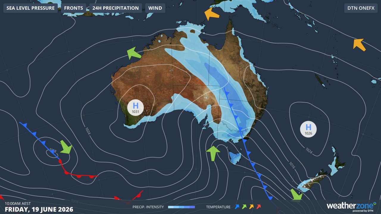
Image: Synoptic chart for Friday, June 19, 2026. Source: Weatherzone.
In all of the cities mentioned, cooler conditions are about to set in. Indeed, the cool air has arrived in Adelaide, where the maximum is to reach just 15°C this Thursday, with maximums hovering around 14°C or 15°C for the next week.
You can see the cold front pushing across the southeast on Friday in the synoptic chart above. It’s not the strongest cold front you’ll ever see, but it’s the most active cool system to cross southeastern Australia over the last two weeks.
Snow lovers can expect a few centimetres of the fluffy white stuff at higher elevations this weekend, but it’s unlikely that this system will be the big "season-starter" everyone is hoping for, as much of the moisture arrives (as rain) before the coolest air kicks in.
Please check the Weatherzone snow page for the latest alpine conditions and forecasts.