
Deepest July snowpack in a decade at Victoria's highest ski resort
The 2025 Australian snow season continues to reach new heights, with Victoria’s highest ski resort Mt Hotham currently boasting a snow depth of 123cm, the deepest July reading in a decade.
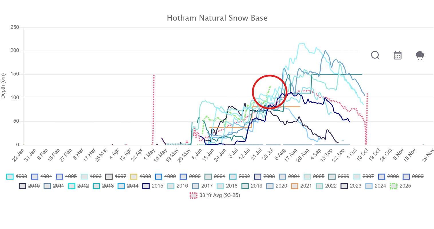
Image: Mt Hotham snow graphs going back to 2015. The green line is 2025 with the red circle indicating how the peak depth recorded to date this July is higher than any recent season. Source: Mt Hotham snow charts.
In New South Wales, a snow depth of just over 170cm was recorded by Snowy Hydro this Monday at Spencers Creek, at an elevation of 1830m roughly halfway between the two largest NSW ski resorts Perisher and Thredbo.
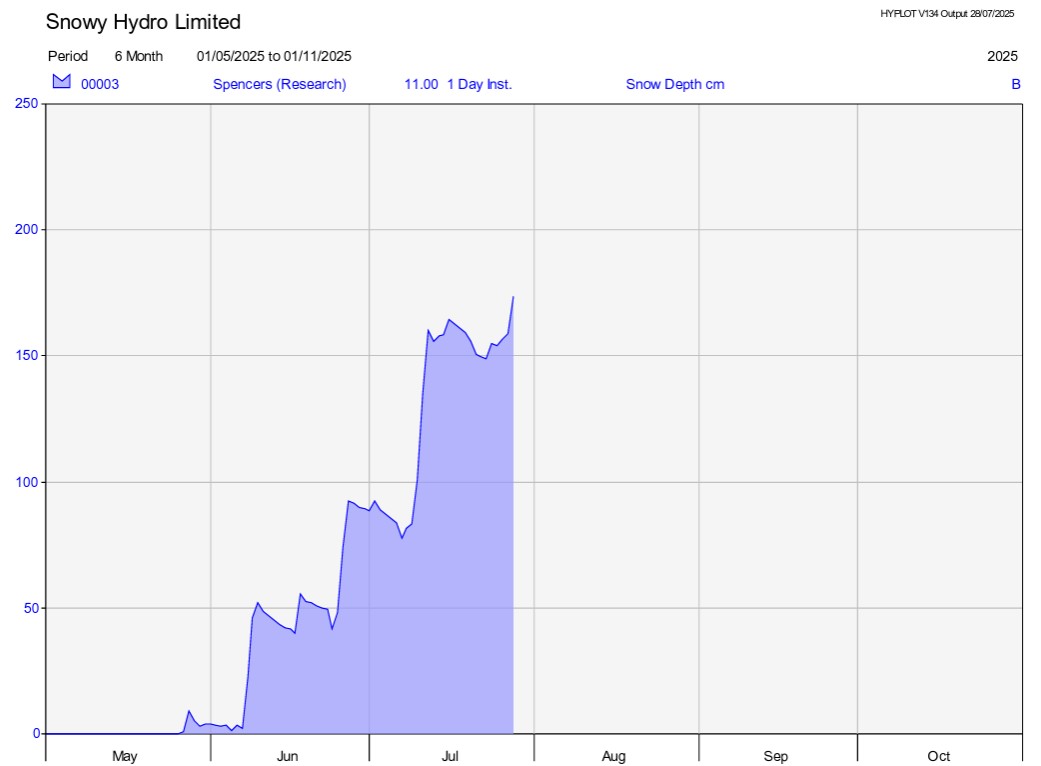
Image: Running snow depth at Spencers Creek in the 2025 snow season, as recorded by Snowy Hydro’s new experiment automated daily depth readings. Source: Snowy Hydro.
Given that this season started with a big blizzard on the opening weekend in early June, most Australian ski resorts are now facing the happy prospect of a long, consistent season stretching well into September. There’s even a good chance that the snow will last until the traditional closure in the first weekend of October for the first time since 2022.
But the key word in the previous paragraph was "most", as in most resorts have an abundance of snow. Unfortunately, this is not true for Australia’s lowest ski resorts.
Just a few hundred metres of elevation makes all the difference for snow accumulation in the Australian alpine region. We saw a good example of that with the big low pressure system that lashed the resorts with a mixture of strong wind, snow and rain over the weekend and into the new week.
Mainland Australia’s two lowest resorts – Selwyn Snow Resort in NSW and Mt Baw Baw in Victoria – both have maximum elevations around 1500-1600m, and saw more rain than snow in the weekend system. Both resorts currently have just three of their seven ski lifts spinning on a snow base which reaches no more than 40cm in areas augmented by snowmaking.
Victoria’s so-called "big three" – Hotham, Mt Buller and Falls Creek – all top out at around 1800m above sea level, so the runs are in great shape on all but the lowest slopes.
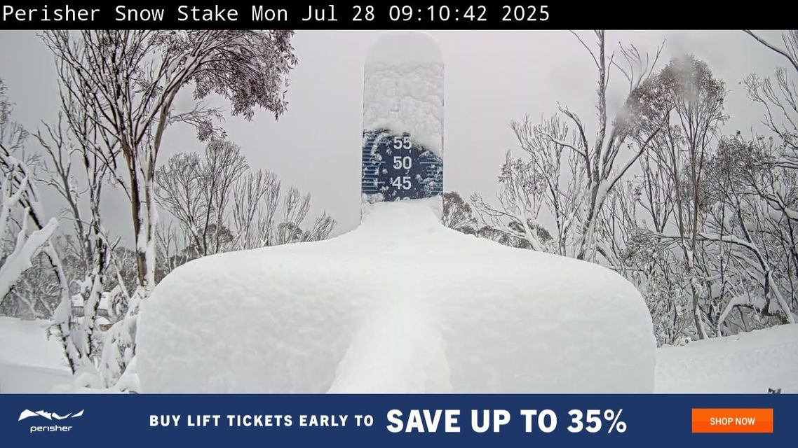
Image: The Perisher snow stake on the morning of Monday, July 28, 2025.
It’s a similarly positive story at the highest NSW resorts – Thredbo, Perisher and Charlotte Pass – which all have maximum elevations of close to 2000m or even slightly higher and which all received more snow than rain up high over the weekend.
Meanwhile Tasmania’s only commercial ski resort – Ben Lomond near Launceston with a maximum elevation of just over 1500m – is also struggling with limited terrain open after a weekend which saw heavy rain as the mercury frustratingly hovered just above zero.
The good news in the short term is that colder temperatures will prevail this week ahead right across the high country of the mainland and Tasmania.
While moisture will be limited with only a few centimetres of snow expected to accumulate, conditions should be ideal for snowmakers to get to work and top up high traffic areas and some of the more patchy lower slopes.