
Brisbane’s wettest day since Cyclone Alfred
Heavy rain has fallen across southeast Queensland and northeast New South Wales, with numerous locations receiving more than 100mm in the 24 hours to 9am Wednesday, most of which fell on Tuesday afternoon and evening.
- North of the Qld/NSW border, the highest fall was 129mm at Oyster Creek near Burleigh Heads on the southern part of the Gold Coast.
- South of the Qld/NSW border, 123mm was recorded at Goonengery, not far inland from Byron Bay.
In Brisbane, the airport received 61mm while 53.8mm fell in the city. These were the heaviest daily falls at these sites in October for four and five years respectively, and also the highest falls at both locations since Cyclone Alfred drenched the city in March.
Brisbane has had a topsy-turvy year for rainfall. The most notable feature on the graph below is obviously the massive rainfall spike caused by Cyclone Alfred.
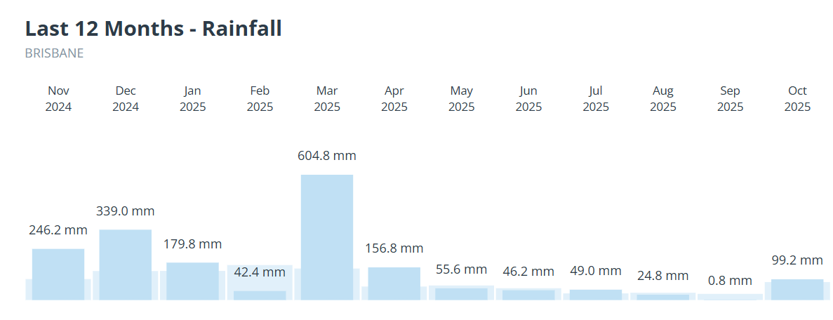
Image: Rainfall in Brisbane (sky blue) compared to the average (paler blue) in the 12 months since November 2024.
After a relatively wet summer, Alfred delivered Brisbane’s wettest day in half a century, as well as the city’s wettest three-day spell on record (676.8mm).
The damp autumn continued into April, before Brisbane dried out through the cooler months in the middle of year, as it typically does. In September, the rain gods could not spare even a millimetre of rain for Brisbane, with the city recording just 0.8mm – its driest September in 38 years.
After a dry start to October with no rain over the first 12 days and just 10.8mm up to October 26, Brisbane's running total for October is now 99.2mm, which has exceeded the monthly average of 85.8mm at the current city site, which has been operational for 25 years.
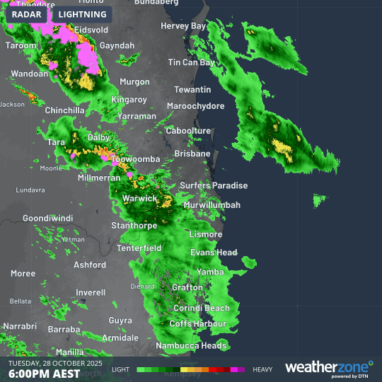
Image: Six-hour radar loop to midnight (AEST), showing steady precipitation associated with the second trough crossing southeast Qld and northeast NSW.
What caused the heavy overnight rain?
"The heavy rain was caused by two distinct trough lines, which produced around 30mm each,” Weatherzone meteorologist Joel Pippard explains.
"The first, around midday, was a weak coastal trough, and the second, around 9pm, was a trough pushing in from inland which tapped into some tropical moisture coming in all the way from the Top End."
Skies have now cleared this Wednesday over Brisbane and most of the areas mentioned in this story, however wet weather will return soon, with a persistent onshore flow of northeasterly winds generating the potential for showers for much of the week. Our Brisbane forecast is here.