
Brisbane's driest September in 38 years, Cairns’ wettest in over a century
Parts of southeast Queensland just had a remarkably dry start to spring, with Brisbane registering its driest September since 1987.
Rainfall was variable across Queensland in September as cloudbands and bursts of tropical moisture delivered healthy totals in the state’s southwest and northeast, while a broad corridor of lacklustre rainfall stretched from the southeast to the northwest.
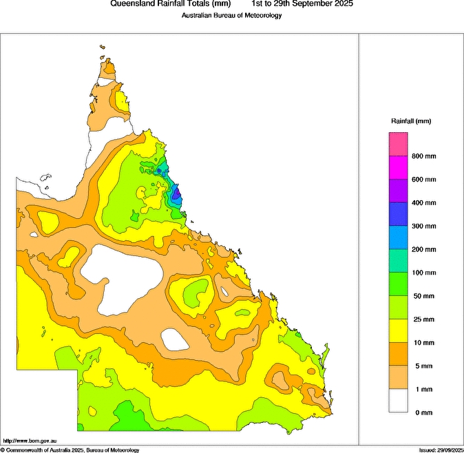
Image: Observed rainfall during September 2025 to date. Source: Bureau of Meteorology.
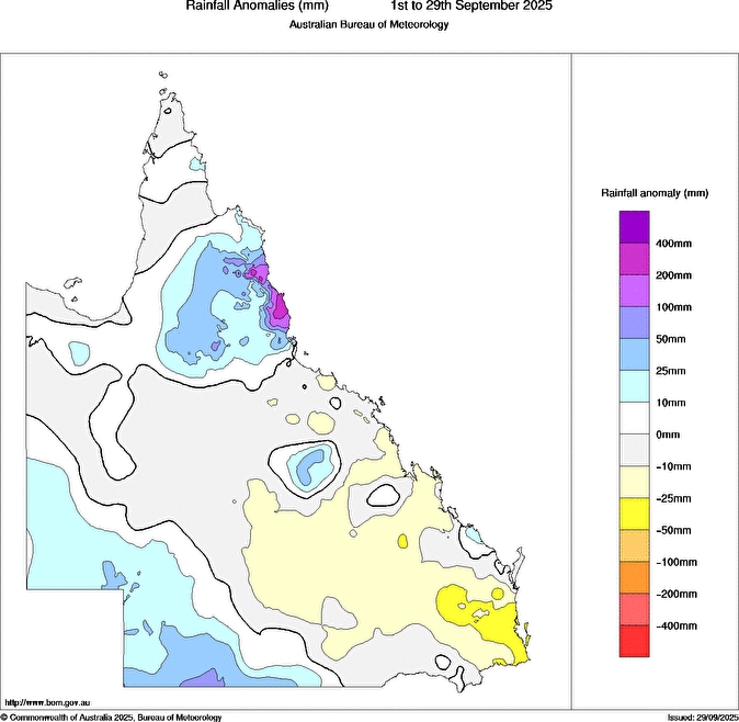
Image: Observed rainfall anomalies during September 2025 to date. Source: Bureau of Meteorology.
Brisbane only collected 0.8 mm of rain through the entire month, making it the city’s driest September in 38 years and its 4th driest in records dating back to 1840.
Townsville also only received 0.8 mm during the month, although this was more than the 0 mm they saw in September last year.
A bunch of locations further inland had no rain at all this September, including Blackall, Hughenden and Richmond, but this wasn’t the first rainless September for these places.
One area that saw lots of rain this September was the North Tropical Coast, where a six-day deluge in the middle of the month dumped more than 600 mm of rain in some areas. This was a remarkable period of rain considering September is typically the region’s driest month of the year. Topaz’s 701 mm, Innisfail Airport’s 351 mm and South Johnstone’s 320 mm were standout monthly totals in the region. For South Johnstone, this was more than three times its monthly average and the wettest September in 27 years. In Topaz, more than 370 mm fell in a single day.
Cairns Airport received 148.4 mm in September, while the Cairns Racecourse rain gauge picked up 273 mm. This amounted to the wettest September since the mid-1800s in Cairns.
September’s variable rainfall across Qld will affect bush and grass fire potential through the middle of spring. Areas that were dry in September, including the state’s southeast and central inland, will have heightened fire potential in October due to enhanced curing boosting early-season fire fuel loads.
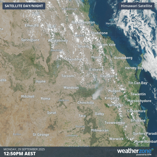
Image: Satellite images showing fires in southeast and central Qld on Monday, September 29, 2025.
Satellite images captured on Monday showed numerous fires causing large smoke plumes across the Maranoa and Warrego, Central Highlands and Coalfields, Darling Downs and Granite Belt, and Wide Bay and Burnett Districts. Large fires like these ones will be a frequent sight on the skyline until the parched landscape receives decent rainfall.