
Why the 2026 winter was the warmest on record across large parts of Australia
The 2026 Australian winter was the warmest on record across huge parts of the country, and at hundreds of individual locations – including our two largest cities, Sydney and Melbourne, and the national capital Canberra.
But why?
Here are five key factors which contributed to unprecedented warmth in the era of meteorological record-keeping, which dates back as far as the 1850s at major weather stations like Observatory Hill in Sydney.
El Niño
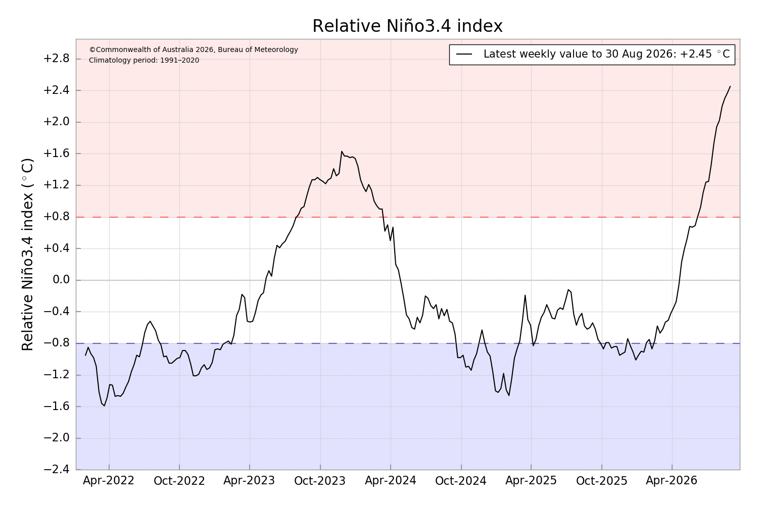
Image: The current El Niño just keeps strengthening, according to the Relative Niño3.4 index. Source: BoM.
El Niño has previously contributed to some of Australia's warmest, driest winters on record – as well as many of our worst snow seasons.
For example, the two years with the lowest peak season snow depth at Spencers Creek in NSW (elevation 1830m, as measured throughout winter by hydro-electric operator Snowy Hydro) were 1982 and 2006 – both of which were El Niño years.
El Niño makes rainfall and snowfall less likely in Australia by reducing rainfall and cloud cover. Sunnier days also tend to increase average maximum temperatures in the country's southeast, including in the Australian Alps.
It's worth noting that despite the presence of El Niño, winter rainfall in Hobart, Canberra and Melbourne was close to average across the season as a whole, while Adelaide's rainfall was above-average in each month of the 2026 winter.
But the wet weather often had tropical rather than polar origins, which brings us to our second point...
Lack of cold air with frontal systems
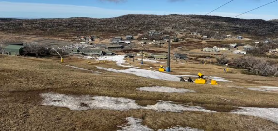
Image: There was minimal natural snowfall and it was even too warm for snowmaking at Perisher Valley, NSW, during much of June 2026. Source: Steve Smith.
You didn't hear phrases like "polar outbreak" or "Antarctic blast" often in the 2026 Australian winter.
There were no significant snowfalls in marginal snowy locations like the Central and Northern Tablelands of New South Wales this winter. Nor was snow reported in major population centres like Canberra (ACT) or Ballarat (Vic) which are high enough for light snow flurries (and even occasional settled snow) in the coldest winter systems.
That's because the 2026 winter was marked by a lack of strong cold fronts passing over southeastern Australia.
While relatively brief bursts of cold weather did occur, prolonged cold spells were absent, with most cold fronts being pushed southwards by persistent blocking high pressure systems.
The positive Southern Annular Mode (SAM) in June
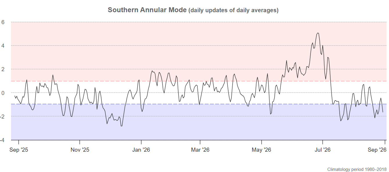
Image: The last 12 months of SAM data, up to the end of August 2026. Source: BoM.
The 2026 Australian winter started with a brief moment of hope for snow enthusiasts, when a moderate snowfall of 10 to 15 centimetres coated the Australian high country in white just in time for the official snow season opening on June 6.
But like the skiers and snowboarders on the slopes, the snow cover went downhill from there.
For just the second time on record, there was officially no snow at Spencers Creek in NSW at the start of July, after June was marked by a distinct lack of cold fronts across the southeast corner of the country. This pattern was typical of a strongly positive Southern Annular Mode (SAM).
The SAM is a climate driver which influences the north-south displacement of the belt of powerful winds which flow year-round from west to east over the Southern Ocean, relative to where the belt would normally be positioned at a given time of year.
A positive SAM means that the belt of westerlies is further south than usual. This led to infrequent intrusions of cold weather systems right across the southeast, and it's why almost no fresh snow fell across the Australian Alps in June.
It's also a large part of the reason why (to use just one example from southern Australia) Melbourne's maximums and minimums were both more than two degrees above average in June, even though the month was slightly wetter than average.
Above average sea surface temperatures around Australia
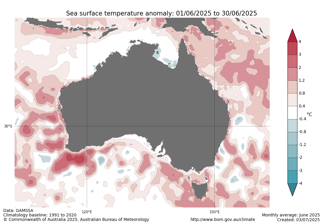
Image: Sea surface temperatures anomalies across Australia in June 2026. Source: BoM.
As the map above shows, sea surface temperatures around Australia were warmer than average during June. This general pattern continued throughout the winter.
When air passes over warmer-than-average water, it absorbs some of the heat, which means slightly warmer temperatures as the air moves inland.
Several times this winter, warmer sea surface temperatures off northwestern WA helped fuel northwest cloudbands, which brought rain (along with relatively mild temperatures for winter) all the way to the southeastern corner of the country.
The underlying influence of climate change
Climate change played a significant role in this year's warm Australian winter.
As mentioned above, El Niño years tend to coincide with warm winters, and there were other broad-scale and localised factors at play behind the warm 2026 winter.
So while the ongoing trend of global atmospheric and oceanic warming wasn't the only factor behind this winter's warmth, climate change helped turn what might have been a moderately or even very warm winter by historical standards into the warmest on record in many areas.