
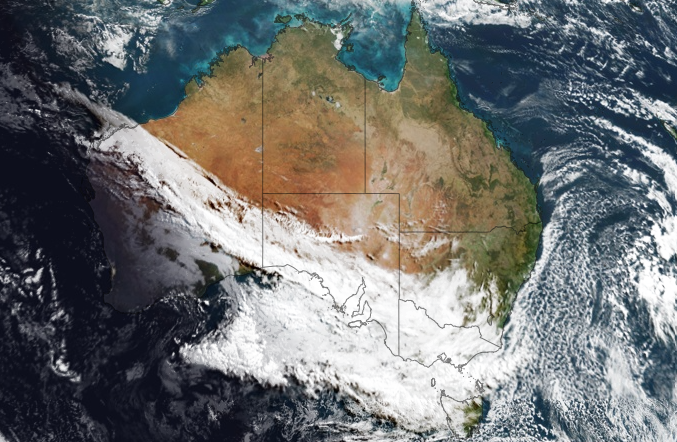
Two classic winter cloud patterns in one
Take a look at that beautiful satellite image this Thursday morning.
After the first significant high country snowfall of the season on Tuesday, Thursday's satellite image is another reminder that winter is here, as it reveals two classic winter cloud patterns.
On the left, we’ve got a classic northwest cloudband. On the right, a field of speckled cloud off the east coast. Let's talk briefly about each type of cloud and what they mean.
Northwest cloudbands
- Northwest cloudbands are vast layers of cloud that flow over Australia from the northwest. Once fully developed, the cloudband stretches across the country like a sash – just like today’s sat pic.
- They form when humid and warm tropical air over the Indian Ocean moves towards the southeast. As this warm and humid air moves further south, it rises over cooler air in the mid-latitudes and produces clouds.
We actually had another northwest cloudband in the last week of May after having not seen one for many months. It brought welcome rain to plenty of places that hadn’t seen decent falls in ages, including Adelaide.
And now we've got another one. This one has already delivered good falls to parts of southwest WA and is delivering light falls this Thursday morning to parts of southern SA including the Eyre and Yorke Peninsulas.
This morning's rain is far from the high totals locals in those areas would be hoping for, but the good news is that showery weather should persist throughout the week, even if only light falls are likely.
The cold air mass that struck south east Australia a glancing blow on Wednesday is now over the Tasman Sea. This is aiding the development of a low pressure system that will maintain cool southerly winds into next week. pic.twitter.com/8FDBArmsjV
— Andrew Miskelly (@andrewmiskelly) June 12, 2024
Speckled cloud fields
- As for speckled cloud, the pattern occurs when cold air moves over a relatively warm area of ocean, causing a large number of individual cumulus clouds to develop over a broad area with patches of clear sky in between.
- Speckled cloud fields are very common in the Southern Ocean at this time of year, and you'll also frequently see them in the southern Tasman Sea.
What's unusual about today’s satellite image is how far north the speckled cloud mass has travelled. Speckled cloud can clearly be seen in the waters off southern Queensland.
With such cold air tracking north, and with the cloud and moisture staying well offshore, it's no wonder that nights are currently very chilly in Queensland, especially in the southern inland.
Indeed, Queensland recorded its lowest temperature of the year to date on Thursday morning, with –2.3°C at Applethorpe, down near the NSW border on the Granite Belt.
The good news for anyone hoping to warm up in the winter sun is that despite the presence of two such striking cloud features on Thursday’s satellite pic, the rest of the week looms as mostly dry across the continent – the exception being those showers we mentioned in southern parts of South Australia.