
Northwest cloudband to bring welcome rain
There's a feature on this week's weather charts which we haven't seen for many months in Australia and which is a sign that winter is almost upon us: a northwest cloudband.
- Northwest cloudbands are vast layers of cloud that flow over Australia from the northwest. Once fully developed, the cloudband stretches across the country like a sash from the northwest to the southeast.
- Northwest cloudbands form when humid and warm tropical air over the Indian Ocean moves towards the southeast. As this warm and humid air moves further south, it rises over cooler air in the mid-latitudes and produces clouds.
READ MORE: WHAT IS A NORTHWEST CLOUDBAND?
Usually, northwest cloudbands produce rain – sometimes light, sometimes quite heavy – but usually rain of the steady, soaking variety rather than the bursts of showers which typically lash southern Australia from southwesterly cold fronts.
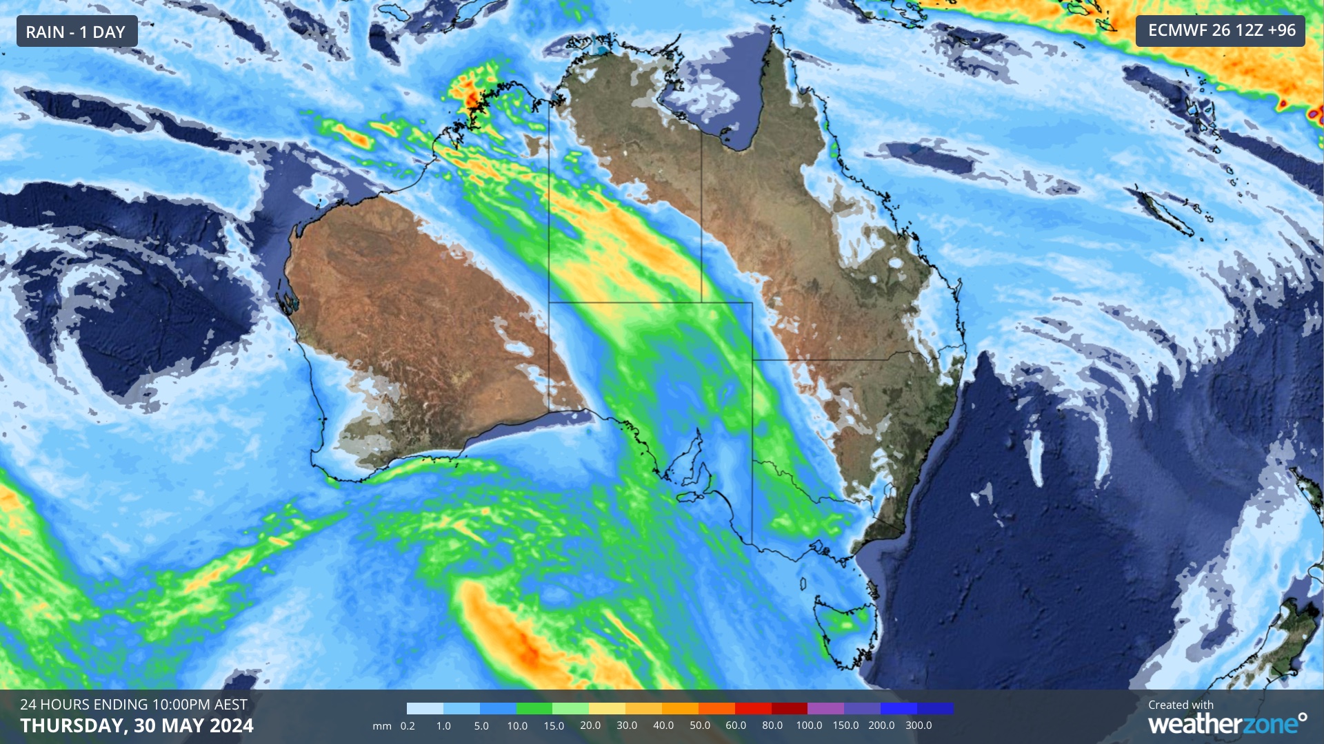
The chart above shows one prognosis for rain produced by this week's northwest cloudband in the 24 hours to 10 pm this coming Thursday.
For parched parts of South Australia, Victoria and inland NSW, this is a welcome forecast.
We wrote last week that Adelaide was facing its driest May on record if no rain arrived before the end of the month, but that there was a glimmer of hope for a system later this week. That system now appears increasingly likely, with showers beginning later on Wednesday, then a rainy Thursday before showers and storms start to clear on Friday.
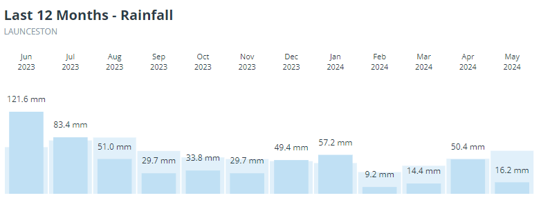
Melbourne should also see some rain from Thursday into Friday, as should northern Tasmania, which has had an exceptionally dry start to the year, as the chart below for Launceston shows. Indeed, Tasmania's second-largest city has seen above-average rainfall in only two of the last 10 months.
For the snow country, northwest cloudbands can be either a blessing or a curse, and sometimes both. It all depends on whether they interact with cold air from the Southern Ocean, and if so, when.
If most of the moisture from a northwest cloudband precedes an injection of cold air, ski resorts will see rain, and often it’ll be heavy. In an ideal scenario, cold air will arrive before the moisture has passed over the continent and heavy snowfalls will occur. Perhaps most commonly, you get a mix of rain and then snow.
Models currently disagree about the snow potential of this system, although there's a chance of heavy weekend snow if a cut-off low pressure system develops. But that's a story for later this week.
READ MORE: WET WEEK AHEAD FOR AUSTRALIA
For now, it appears that at least some rain is coming to areas of SA, Vic, NSW and Tas that desperately need it and we'll keep you updated on this system throughout the week.