
Todd River rages through Alice Springs for second time in three months
It's happening again. Frogs are croaking and water is flowing as the normally dry Todd River in Alice Springs does an excellent impression of what many of us consider to be a "real river".
In November, the Stuart Highway closed, and a man clung to a tree for six hours after his car was swept away when The Todd burst into life in the midst of the wettest November on record in Alice Springs.
The iconic outback town of 25,000 residents recorded 218.2 mm for November 2021, with a whopping 100.2mm falling in 24 hours on November 10, which was the heaviest daily rain in 21 years at Alice Springs.
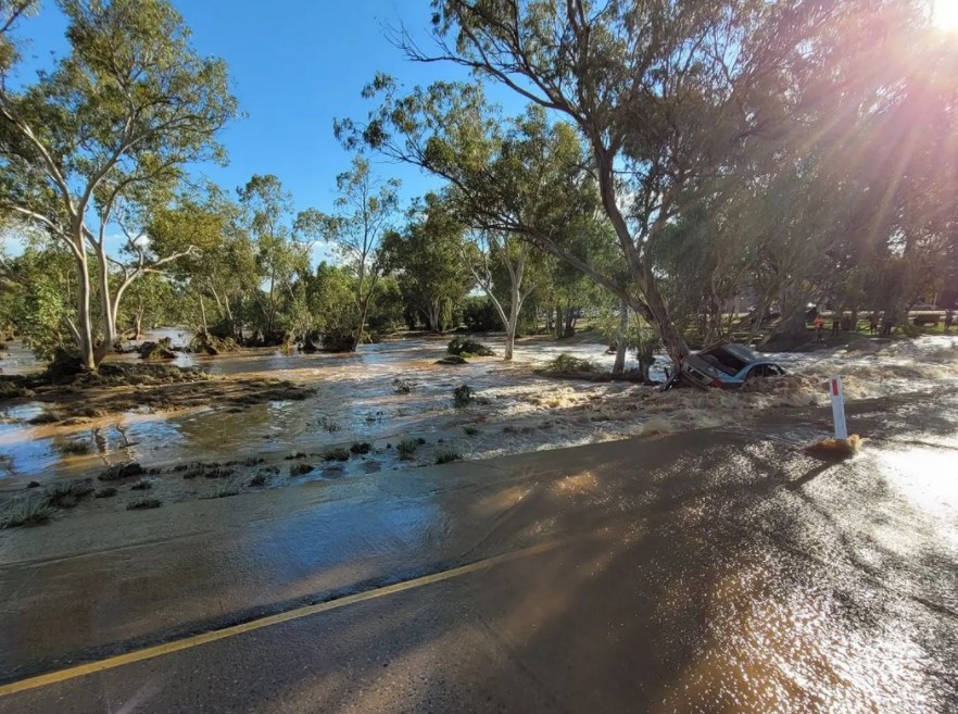
Image: A reminder to never drive through floodwaters. The Todd River on November 10th, 2021. Source: @lucy.blom via Instagram.
This time around, there has been no exceptionally heavy daily rainfall amount, however three cumulative days of rain have left 103.2 mm in the gauge.
- The last two days of January saw 36.8 mm and 38.8 mm respectively.
- Another 27.6 mm fell yesterday and overnight (and will be recorded as February 1 rainfall).
How unusual is late spring and summer heavy rain in Alice Springs?
The short answer is that it's quite unusual, though far from unheard of.
The Todd River flowing nicely north of #AliceSprings this morning. Lots of frogs 🸠pic.twitter.com/mjUAxTfkES
— Rohan Barwick (@rohwick) January 30, 2022
The period from November to March is the wettest five months of the year in Alice Springs, as moisture from the Northern Territory's monsoon (or wet season) occasionally brings rain further south.
The average rainfall in those five months is:
- Nov 30.7 mm
- Dec 38.5 mm
- Jan 40.1 mm
- Feb 40.9 mm
- Mar 31.9 mm
But the heaviest rainfall on record in those five months is:
- Nov 218.2 mm
- Dec 228.9 mm
- Jan 251.4 mm
- Feb 241.6 mm
- Mar 356.8 mm
That shows that the wet season can indeed deliver a taste of Darwin to the NT's second city on occasion.
And when it does, it's time to take those road crossings with great caution or avoid them altogether as directed.
The current flood warning for the southern NT states that:
"Significant flooding of low lying areas and river rises are expected. Many secondary roads are now impassable and primary routes are affected as well in places. Many roads, and possibly primary and secondary highways, may be further affected. Some communities and homesteads may become isolated. Check road conditions before travelling."
Please check our warnings page here.
The Todd River is flowing in Mparntwe (Alice Springs). Probably the last time I’ll see this. (3 months till DDay) pic.twitter.com/W0CQuIGpFN
— Dr Adele Millard, MBA, BA(Hons)💉💉💉 (@trufflehuffer) January 30, 2022