
The remarkable behaviour of ex-Tropical Cyclone Ellie
A truly remarkable image has been produced by the BoM which shows why ex-Tropical Cyclone Ellie inflicted such persistent rainfall and heavy flooding in parts of the NT and northwest WA.
The WA office of the BoM created this eagle-eye view of the ex-TC's path, from its formation on Dec 21 to the day on which it finally petered out – a stretch of 19 days inclusive.
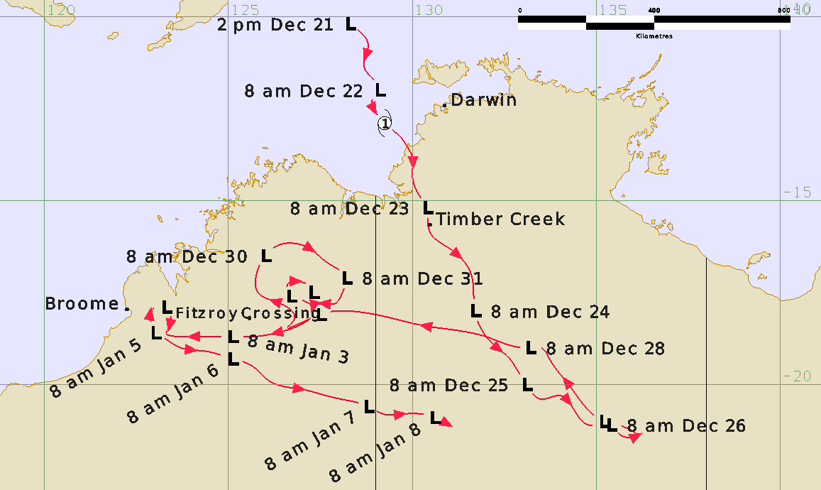
As you can see, this was one weather system that just refused to quit. These systems generally tend to run out of juice within a week or so as the feed of tropical moisture is cut off.
But not this one. After forming over the Timor Sea, Ellie soon downgraded to a tropical low as it moved inland in a southeasterly direction.
At this point, such systems usually lose intensity rapidly, but as Weatherzone meteorologist Joel Pippard explains, the entire system was continually linked to the monsoon trough. That meant it was able to stick around much longer due to the persistent northwesterly feed of moist air from the other side of equator.
"Usually the moist feed would break off when it got to the interior and the system would start losing moisture and peter out. That's what eventually happened on January 8, but over the Boxing Day period, it stayed joined to the monsoon trough."
As the image above shows, after Boxing Day, ex-TC Ellie turned towards northwest WA, delivering extremely heavy rain to the Kimberley.
- As we reported on January 3, one rain gauge in the vicinity of the flood-devastated town of Fitzroy Crossing received over 800 mm of rain, which explains why the Fitzroy River experienced an unprecedented flood level of 15.8 metres.
- In our follow-up stories, we explained that the vast amount of moisture in the former tropical cyclone delivered heavy rain as far south as Alice Springs after making a final turn to the southeast before eventually becoming cut off from the monsoon trough and quickly dissipating.
Meanwhile, Prime Minister Anthony Albanese joined WA Premier Mark McGowan and other officials to tour the area on Monday, with WA authorities announcing emergency relief funding.
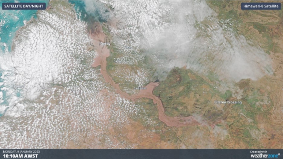
The satellite image above (taken Monday) shows the dramatic sight of the Fitzroy River in full flood.
The chance of light showers and even a storm or two will persist over the next week in the Kimberley region, however there is little chance of the sort of heavy rain which fuelled the record-breaking flooding.