
Rainfall totals top 200mm in NSW/Qld border deluge
Extremely heavy rain continues to fall in the NE corner of New South Wales and SE Queensland this Friday morning, with some locations having recorded more than 200mm in 24 hours.
Notable observations to 9am Friday (AEDT) in NE NSW included:
- 241mm at Doon Doon, about 20m northwest of Byron Bay, which included 162mm in just six hours
- 208.8mm at Green Pigeon, a weather station near the town of Kyogle
- 176.5mm at Main Arm, a weather station near Mullumbimby
Notable observations to 9am Friday (AEST) in SE Qld included:
- 128mm at Tallebudgera Creek Mouth on the Gold Coast
- 127mm at Tallai, near Hinze Dam in the Gold Coast hinterland
- 126mm at Burleigh Waters on the Gold Coast
What’s causing this ongoing heavy rain?
"A deep layer of atmospheric moisture over southeast and central Qld this Friday is providing fuel for heavy rain," Weatherzone meteorologist Ben Domensino explains.
"A southerly change that moved through northeast NSW overnight and southeast Qld this morning has also triggered areas of heavy rain near the coast."
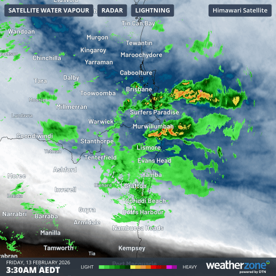
Image: Combined atmospheric water vapour and rain radar imagery for the six hours from 3:30am to 9:30am (AEDT) on Friday, February 13, 2026.
You can see the available atmospheric water vapour (the blue layer) in the loop above.
The loop also shows how heavy rain (green, red and yellow) concentrated around the eastern Qld/NSW border overnight, with the southerly beginning to push heavy showers onshore from the coast.
How long will this rain continue?
This slow-moving low pressure trough will continue to linger over southern and central Qld for the next few days, causing widespread rain and thunderstorms across the state – as well as in the northeast corner of NSW.
Severe thunderstorms are likely to break out at times, with heavy rainfall that may lead to flash flooding.
BoM warnings
At 6:43am (AEST), the BoM issued a severe weather warning for heavy rainfall for parts of Queensland’s Southeast Coast forecast district.
The BoM warned that six-hourly rainfall totals between 50 to 90 mm were likely, with isolated higher falls to around 150 mm possible.
At 9:52 am (AEDT), the BoM issued a severe thunderstorm warning for parts of the NSW Northern Rivers forecast district.
The BoM stated that severe thunderstorms could cause flash flooding over the next several hours.
How to stay safe during flooding
Some roads may become impassable as flooding develops over Qld and northeast NSW later this week. Anyone living in these areas should keep an eye on the latest warnings over the next few days and take the following steps to keep safe:
- Don’t enter floodwater. This includes driving, walking or swimming.
- Obey road signs and plan ahead before travelling through flooded areas.
- Avoid flooded drains, rivers, streams and other waterways.
- Check the Queensland Government website or the NSW Hazards Near Me app for local emergency warnings and advice.
- Contact the SES on 132 500 for emergency assistance. In life-threatening situations, call 000 (triple zero).