
Rain arriving where it is desperately needed in Victoria, Tasmania and South Australia
A rainband is crossing southeastern Australia this Tuesday morning, and while it’s only delivering moderate rainfall totals, it’s just the beginning of a large, complex weather system that will bring significant rain to areas where it is very much needed.
In recent weeks, the NSW coastline and adjacent ranges have received most of the rainfall in southeastern Australia. To use three capital cities as an example:
- To 9am Tuesday, Sydney has had a whopping 389.6mm of rain in August (nearly five times its monthly average).
- To 9am Tuesday, Melbourne has received just 18.4mm in August (barely a third of the monthly average).
- To 9am Tuesday, Adelaide has had a meagre 24.6mm in August (less than half its monthly average).
But the prevailing winds have now swung to a more classic winter pattern, with westerlies kicking in across southeastern Australia rather than the easterlies which have dominated of late.
On Monday, Weatherzone meteorologist Ben Domensino explained that a series of powerful cold fronts and low pressure systems would cause multiple rounds of rain, blustery winds and snow across a broad area of Australia this week. Today’s rainband is just a prelude.
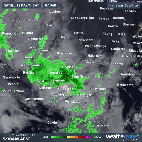
Image: Four-hour combined radar and satellite loop for Victoria and adjacent areas from 5:30am to 9:30am (AEST) on Tuesday, August 26, 2025.
The loop above shows rain streaming down across Victoria from the northwest as dawn broke on Tuesday morning.
Note how Melbourne is "shielded" from the green blobs of rain on the radar. The rain dissipates before it reaches the city, as often happens in northwesterlies due to the blocking effect of the Macedon Ranges (rain coming directly from the north tends to reach Melbourne as it passes through what’s called the "Kilmore Gap").
That’s why two weather stations just north of the Macedon Ranges picked up 10mm or slightly more (the highest 24-hour totals in Victoria to 9am Tuesday) while Melbourne’s rain gauge was empty.
But Melbourne and many other parts of Victoria, SA, Tasmania and southern NSW can expect a decent drop in coming days, as two separate pools of cold air from the Southern Ocean spread across the southern half of Australia.
As these frigid air masses move in during Wednesday and replace the current relatively mild air, persistent heavy showers will occur, with heavy snowfalls in the high country that will lower to adjacent hills and tablelands on Friday and Saturday.
For Melbourne, rainfall totals of up to 5mm or slightly higher can be expected for each of the next five days. For Adelaide, the news is even better. The SA capital can expect up to 10mm today and Wednesday, with totals potentially closer to 20mm on Thursday.
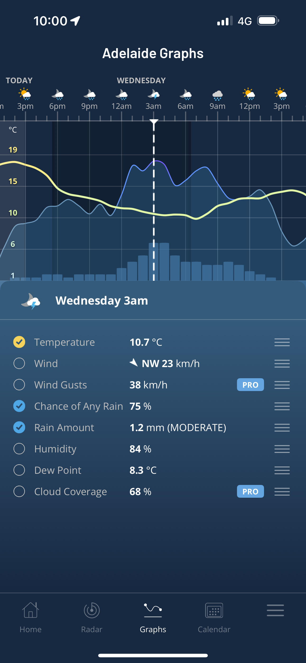
Image: Chance of rain and predicted rainfall totals for Adelaide, SA, as seen on the Hourly Graph on the Weatherzone app.
Unfortunately, heavy rainfall is not expected in some of the more northerly agricultural regions of South Australia and Victoria that have experienced severe rainfall deficiencies this year (and in many cases going back much further).
For example, Renmark in the SA Riverland forecast district has had a paltry 56.6mm of rainfall in 2025 to date. While Renmark is a dry area that relies on Murray River water for irrigation, it is still sitting on much less than half its running yearly average rainfall of 138.1mm.
The nearby Murray River town of Loxton is enduring its driest year since 1929.
For Loxton, Renmark and the Victorian city of Mildura (90 minutes east of Renmark), no more than 5mm is expected this Tuesday and Wednesday, with rainfall potential diminishing from Thursday onwards.
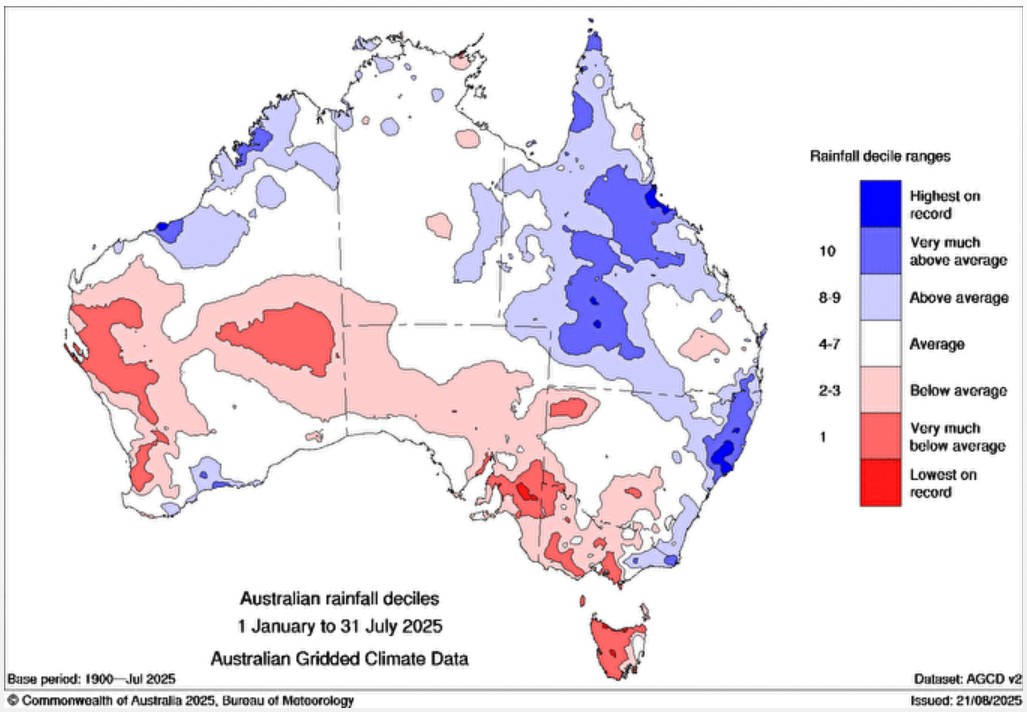
Image: Rainfall deciles from January to July, 2025. The majority of areas shaded in pale and dark red in Vic and SA have also seen low rainfall to date this August. Source: BoM.
But for more southerly locations on the southeastern mainland, this period of dynamic midweek weather should deliver significant rainfall as bands of moisture push in from the Southern Ocean.
Tasmania should also do well from the coming systems.
For example Wynyard – on Tasmania’s northern coastline just west of Burnie – has seen below-average rainfall in each month of 2025 to date. Indeed, its running annual total of 365.6mm to 9am Tuesday is the lowest on record, with data going back to 1907.
While Wynyard won’t see huge totals in coming days, it will see persistent showers and is already damp this Tuesday after 8.4mm overnight and further showers since 9am, as the patchy rainband crossing Victoria makes its way across Bass Strait.