
Powerful polar blast roaring towards Australia
A strong cold front with a frigid airmass originating in Antarctica is tracking towards southeastern Australia.
The freezing system looks likely to arrive on Monday, delivering rain, wild winds and potentially heavy snowfalls to the mountains in Tasmania, Victoria, southern NSW and the ACT.
A short-lived wintry outbreak hit the SE mainland last weekend, delivering a few centimetres of snow to the ski resorts.
However the coming system looks to be stronger, colder, longer-lasting and wetter – with the potential for heavy precipitation in a broad arc extending roughly from Adelaide to the ACT.
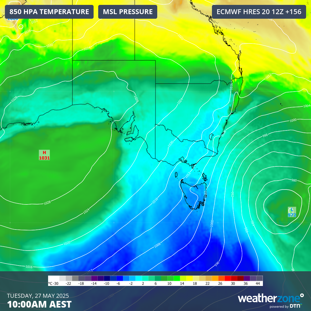
Image: Mean sea level pressure chart for SE Australia on Tuesday, May 27, showing the large tongue of cold polar air.
What this system means for snow
This is the sort of cold front that snow lovers dream about in midwinter, let alone in May. The chart above shows how frigid air is expected to push northwards from well south of Tasmania early next week. The cold air should reach SE Australia on Monday along with plenty of moisture.
In terms of systems of this calibre in May, the predicted set-up is reminiscent of the famous May 28-30 cold outbreak way back in the year 2000, when a metre of snow fell at the ski resorts and an NRL game at Canberra Stadium was played on a field that was white with settled snow.
On 28 May 2000 @RaidersCanberra & @WestsTigers played in the snow. The Raiders narrowly defeated the Tigers 24-22. Courtesy ABC News.
— NFSA National Film and Sound Archive of Australia (@NFSAonline) June 25, 2018
Read more: https://t.co/Aa9Hmuf4gH#Newscaf30 pic.twitter.com/eye1pXr15j
That’s not to suggest that the system will be quite that cold, or that snow will settle across Canberra, but brief snow flurries down as low as Canberra’s elevation (around 600m) appear possible at this stage, with the snow level closer to 400m in Tasmania.
More important for the ski resorts is the quantity of snow rather than the elevation to which it will settle.
Enough snow should accumulate from this system (potentially 50cm or more) to ensure a skiable cover on some runs – especially in areas with snowmaking – in time for the ski season. That’s assuming there’s no major rain event between this system and the season opening on Saturday, June 7.
What this system means for rain
Early indications are that significant rain will fall in large parts of Victoria and southern SA that have endured prolonged rainfall deficiencies which have broken numerous records.
Estimating precise rainfall totals a few days out from a weather event is difficult to do with confidence, however widespread falls of at least 10mm or more are likely in the areas mentioned.
While this system is highly unlikely to be a drought-breaker, many locations will see their heaviest falls to date in 2025 – although that wouldn’t be hard in places like Adelaide which has seen just 30.8mm in total so far this year. At this stage, Adelaideans can hope for falls in the vicinity of 20mm, with Sunday looking like the wettest day.
Western Tasmania has also been relatively dry by its very soggy standards this year. For example, the town of Queenstown has received only half its running yearly average to May 21. But as you can see on the chart below, the west coast – and indeed most of Tasmania – is set for a solid soaking.
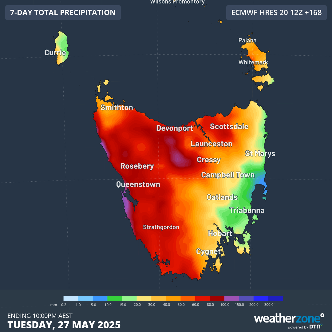
Image: Accumulated Tasmanian rainfall to 10pm Tuesday, May 27, according to the ECMWF model on May 21.
What this system means for wind
Strong and potentially damaging winds will be a feature of this system as it roars its way northwards from the Southern Ocean.
Alpine areas and exposed coastal weather stations in Victoria and Tasmania typically see gusts of 100 km/h or even stronger in these sorts of systems.
It’s also worth mentioning that eastern NSW will be vulnerable to falling trees due to loose soil from the recent extremely heavy rain and historic flooding. While the NSW coast usually sees minimal rainfall from southwesterly systems like this one, it generally doesn’t miss the strong winds.