
Hobart tracking towards warmest May on record
After beginning the month with its warmest May day in 144 years of records (May 1 maximum 26.9°C, old record 25.7°C), temperatures in Hobart have continued to trend well above average, and the city is now looking increasingly likely to register its warmest May on record.
To date in May 2026:
- Hobart’s running average maximum this month is currently 18.6°C. That’s a full four degrees warmer than its average May maximum of 14.6°C.
- Hobart’s running average minimum this month is 9.6°C. Its average May minimum is 7.0°C.
The unusual Tasmania May warmth has not just been confined to the state capital. To cite just one other example, let’s visit Liawenee, the tiny Central Plateau town with just a handful of residents which registered Tasmania’s coldest recorded temperature in August 2020 with a bone-chilling low of -14.2°C.
To date in May 2026:
- Liawenee's running average maximum is currently 12.0°C. That’s almost three degrees warmer than its average May maximum of 9.1°C.
- Liawenee’s running average minimum this month is 3.6°C. Its average May minimum is 0.2°C.
Why has Tasmania been so warm in May 2026?
In addition to the underlying influence of the warming climate, in short it’s down to an absence of regular cold fronts.
The polar airmasses that often visit Tasmania frequently in the cooler months have been blocked from pushing northwards by strong high pressure systems, which have been located further south than usual for this time of year.
It’s worth revisiting the synoptic chart from May 1 to illustrate that. On that day, warmth from Australia’s interior pushed all the way to Tasmania, as air circulated anti-clockwise around the large high pressure system centred over waters near New Zealand.
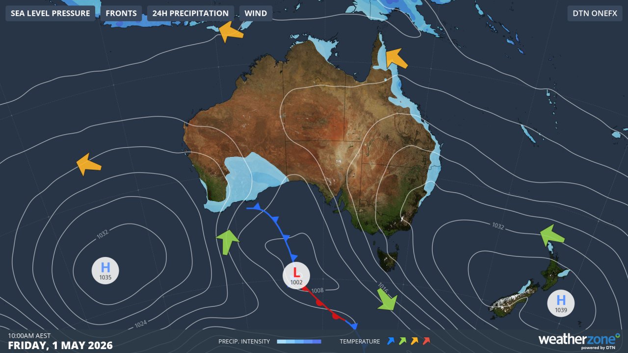
Image: Synoptic chart for May 1, 2026. Source: Weatherzone.
While a cold front on May 6 and 7 delivered snow to elevated parts of Tasmania and the southeastern mainland – and gave Hobart its coldest day of the month with a high of just 12.1°C – it was short lived and was a blip in the otherwise mild Tasmanian weather pattern.
Will the last 12 days of the month be cooler?
A weak cold front has cooled things down in Tasmania this Tuesday, but there’s no real bite to it, and temperatures will continue to hover near, or just above, the May average in most parts of the state this week.
For example, the average May Maximum is 5.7°C at the weather station on kunanyi/Mt Wellington above Hobart at an elevation of 1260m. From this Tuesday through to Sunday, the expected maximums are 8°C, 6°C, 7°C, 9°C, 7°C and 7°C.
With no outbreak of below-average maximums or minimums for the rest of this week – on the back of well-above average temperatures across the first 19 days of the month – it’s likely that numerous monthly records for warmth will be broken right across Tasmania by the end of May.