
Fourth warmest July on record with above-average temps in all states
It might not have felt like it in southern states, with the heaviest snow depth in 21 years in NSW, but Australia as a whole has officially recorded its fourth warmest July on record.
The Bureau of Meteorology published its climate summary for July 2021 on Monday afternoon, and the results point strongly towards the underlying influence of a warming climate.
Every single state and territory saw both minimum and maximum temperatures which were above the historical average in the 30-year period from 1961-1990, which the BoM takes as its statistical yardstick.
Here's a breakdown of some of the key stats:
- Australia's mean temp was 1.77°C above the average.
- Maximum temps in Australia were 1.95°C above average.
- Minimum temps in Australia were were 1.58°C above average.
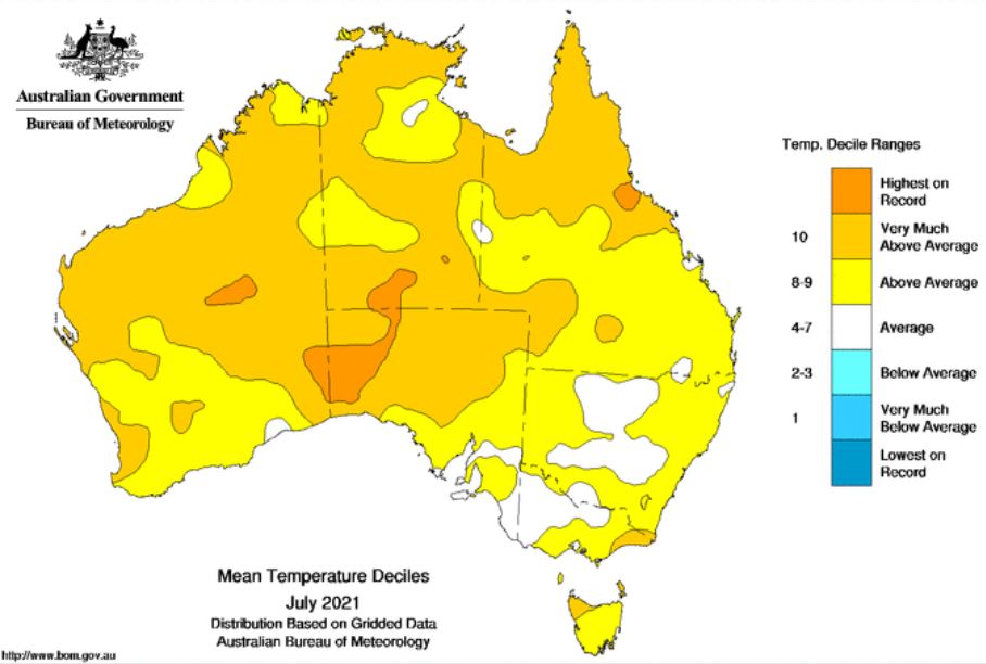
Image: No part of Australia was below average in July. Source: BoM.
Now for a breakdown of max and min temperature anomalies by state:
Maximum temperatures (how much higher than normal)
- QLD +2.19°C
- NSW +0.61°C
- VIC +0.44°C
- TAS +0.65°C
- SA +1.97°C
- WA +1.67°C
- NT +3.32°C (equal highest on record with 2017)
Minimum temperatures (how much higher than normal)
- QLD +2.18°C
- NSW +1.08°C
- VIC +1.00°C
- TAS +0.81°C
- SA +1.39°C
- WA +1.52°C
- NT +1.52°C
Here at Weatherzone, we reported often about the heat up north this July. To cite just one example, last week Weatherzone meteorologist Ben Domensino told you about Townsville's warmest July on record, with max temps almost two degrees above the monthly average of 25.2°C.
With all the above-average temps in the vast northern half of the country, we had a pretty good idea that it would be a warm overall month for Australia.
But it was a little surprising to see that even southern areas were above average during both the day and night. And that begs a question that refers back to the first line of this article:
If it was so warm, why did it snow so much?
In simple terms, snow in southern Australia is most commonly caused by cold fronts which sweep northwards over the southeast corner of the mainland from the Southern Ocean. And in July, there were several strong fronts, each of which delivered heavy snow.
When those sorts of systems arrive, snow usually falls at temps between about -1°C and -4°C. And while average temperatures were half a degree or so above normal in NSW and VIC across the whole month, it was still more than cold enough in the southeast on the days and nights when the fronts crossed the region.
Over the long term, if warming increases by the the predicted two or three degrees above historical norms by the middle of this century, our mainland snow seasons will be in serious trouble.
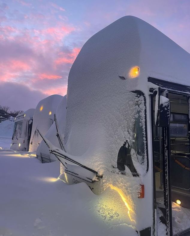
Image: At Perisher, the buses became double-deckers overnight. Source: perisher_resort Instagram.
And what about rainfall in July?
July rainfall was 3% below average for Australia as a whole, but it was well above average in SW WA, SE SA, and along the ranges from NE VIC through NSW to eastern Queensland. Again, this reflects the consistent frontal activity.
It was particularly wet in the SW of WA, as we told you this morning, with Perth's wettest July in 26 years.