
East coast dry spell intensifies as El Niño maintains near-record strength
Much of Australia's east coast and adjacent inland areas remain in the grip of a prolonged spell of dry weather after the first two weeks of spring, on the back of an exceptionally dry winter.
Let's examine some charts and statistics that illustrate the ongoing rainfall deficiencies in Queensland, NSW and Victoria's East Gippsland region, before examining some of the drivers of the dry conditions, including El Niño.
Queensland: relentless dry continues in most east coast areas south of the tropics
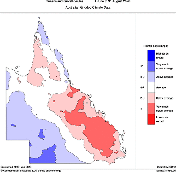
Image: Queensland rainfall deciles for winter 2026. Source: BoM.

At the start of September, we reported that just 9.8 mm of rainfall was recorded across the whole of winter in Rockhampton in Queensland's Capricornia district (just south of the southern extent of the Great Barrier Reef).
While winter is typically quite dry in the region, that was still only 10% of Rockhampton's seasonal average, and the city is yet to record a single drop of rain this spring with no rain in the forecast for the rest of this week.
Brisbane has recorded less than a millimetre of rain to date in September, after below-average rainfall in each month of winter.
One area which has caught some meaningful rain in September is the Sunshine Coast (Tewantin, near Noosa, has had 50 mm), but this region is very much the exception for the Queensland coast south of the tropics.
New South Wales: dry spell continues in all eastern areas except the far North Coast
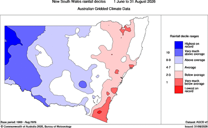
Image: NSW rainfall deciles for winter 2026. Source: BoM.

Bega is just one of many locations on the state's far south coast that had a desperately dry winter, with just 26.6 mm across June, July and August. That was just over 20% of the long-term seasonal average of 128.3 mm.
To date in September, just 1mm of rainfall has registered in Bega's gauge.
Sydney has received just 6.2 mm to date in September, after below-average rainfall in each of the three winter months (and the two months before that).
One NSW coastal spot which has caught some meaningful rain in September is the far North Coast (Ballina leads the way with 48.4 mm) but this region is very much the exception for the entire NSW coastline.
Victoria: no significant spring relief yet for far eastern tip of the state
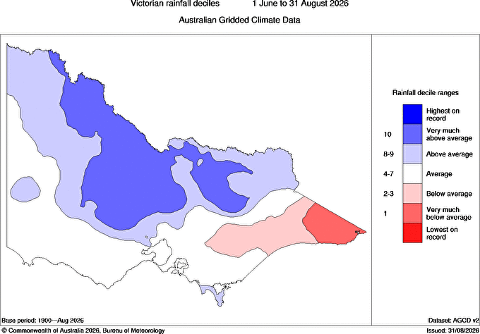
Image: Vic rainfall deciles for winter 2026. Source: BoM.

In our story at the start of September, we mentioned that the East Gippsland town of Mallacoota (which lost more than 100 homes in Black Summer bushfires) received just 78.2 mm of rainfall in the 2026 winter. That was less than a third of its seasonal average of 244.4 mm.
To date in September, 12 mm has fallen in Mallacoota, but the monthly average of 73.7 mm is looking increasingly distant, with only a very light shower in the forecast for the next week.
Melbourne has also been relatively dry this September so far with 12.6 mm recorded to date, although it's worth mentioning that Melbourne had slightly above-average rainfall in the 2026 winter.
As illustrated in the image at the top of this section, the Victorian capital is part of the large chunk of Victoria that dodged the winter 2026 eastern Australian dry spell.
Why eastern Australia was so dry in the 2026 winter
Over the course of the 2026 winter, moisture associated with numerous northwest cloudbands dampened large parts of southern and central Australia, as well as inland parts of eastern Australia, fuelled by tropical air masses that travelled all the way from the Indian Ocean.
Moisture from these systems often petered out before crossing the Great Dividing Range, which is one reason why the east coast was so dry during winter.
It's also highly likely that El Niño played a role in the east coast dry spell, as it typically makes the region drier in winter and early spring. This occurs because El Niño weakens the trade winds that blow moisture-laden air towards the country from the tropical Pacific Ocean.
The most recent reading of the Relative Niño3.4 Index (week ending September 13) stands at 2.51. The strongest on record was 2.65.
The index indicates how unusually warm or cool the central equatorial Pacific Ocean is compared to the average temperature of all global tropical oceans.
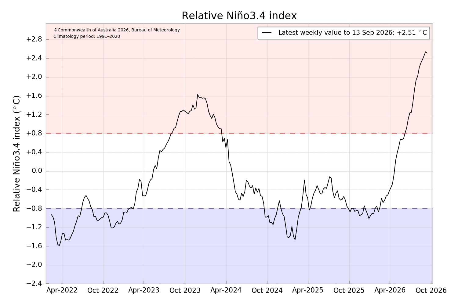
Image: The relative Niño3.4 Index as at September 13, 2026. Source: BoM.
How El Niño could extend the ongoing dry spell
We are now entering a potentially dangerous time of the year, with the bushfire risk increasing in eastern Australia as the landscape continues to dry out and seasonal temperatures inevitably creep upwards.
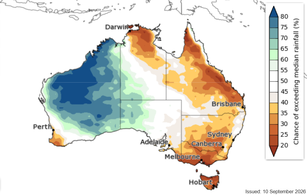
Image: The BoM's season rainfall outlook for October 2026. Source: BoM.
At present, October is expected to be drier than usual across most areas mentioned in this story, according to the BoM. The good news is that the outlook starts to change in November, when wetter weather is predicted.
It's also worth reiterating a point made by Weatherzone meteorologist Ben Domensino earlier this month, when he argued that warm seas near Australia could counteract El Niño’s drying effect this spring.
That's because warmer-than-average water near Australia can supply the atmosphere with additional moisture via enhanced evaporation, which can counteract the drying influence of El Niño.
Farmers, firefighters and all residents of Australia's east coast will be hoping for significant rainfall soon, before the current dry spell escalates into a widespread severe drought.