
Warm seas near Australia could counteract El Niño’s drying effect this spring
A climatic tug-of-war between a strengthening El Niño and unusually warm water surrounding Australia could cause striking weather contrasts across Australia this spring and summer.
El Niño strengthening
El Niño has been gaining strength in the tropical Pacific Ocean over the last few months after it was officially declared by the Bureau of Meteorology in June.
At the end of August, the relative Niño 3.4 index – a measure of sea surface temperature (SST) anomalies in the central tropical Pacific Ocean and a key oceanic index for monitoring El Niño – had reached +2.45°C. This is well above Australia's El Niño declaration threshold of +0.8°C.
.png)
Image: Weekly relative Niño 3.4 index. Source: Weatherzone.
Forecast models predict this El Niño event will continue to strengthen through the southern hemisphere's spring. Some forecast models suggest it could rival or exceed the strongest El Niño events on record, and should peak in late spring or early summer, before weakening early next year.
El Niño can have a big influence on Australia's weather and is typically associated with:
- Below average rainfall over large areas of Australia during winter and spring. However, its influence on rainfall is typically weaker in summer and autumn.
- Above average maximum temperatures for most areas outside the tropics, particularly during the second half of the year.
- More intense daily heat extremes in southern Australia, but with a reduced frequency of prolonged heatwaves.
- An increased risk of dangerous fire days in southeastern Australia as temperatures rise in spring and summer.
- Decreased seasonal peak alpine snow depths and a shorter snow season.
El Niño not acting alone
One important thing to note about El Niño is that it does not act alone. Other influences, such as the Indian Ocean Dipole (IOD), Southern Annular Mode (SAM) and sea surface temperatures near Australia can all affect how El Niño impacts Australia’s weather. In some cases, these other influences can enhance the impact of El Niño in Australia and in other cases, they can counteract it.
One thing that is currently influencing Australia’s weather alongside El Niño is warmer than average seas around much of the country.
El Niño can reduce rainfall over Australia by weakening the trade winds that blow moisture-laden air towards the country from the tropical Pacific Ocean. However, warmer-than-average water near Australia can supply the atmosphere with additional moisture via enhanced evaporation, which can counteract the drying influence of El Niño.
At the beginning of September, sea surface temperatures were running around 0.5–1°C above average around most of Australia, with parts of the Tasman Sea running 2–3°C above average for this time of year.
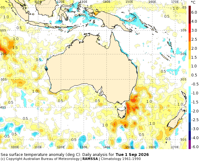
Image: Sea surface temperature anomalies near Australia on September 1, 2026. Source: Bureau of Meteorology.
Forecast models predict that water temperatures will become even warmer than average during spring. According to the Bureau of Meteorology, “SSTs across most of the Australian region are forecast to warm over the coming months, particularly to Australia's west. Warmer waters can enhance atmospheric moisture and energy that can fuel storms and rain systems, increasing potential for high intensity rainfall.”
The map below shows forecast sea surface temperature anomalies in the Australian region in November 2026. The red areas show where sea surface temperatures are predicted to be warmer-than-average for late-spring, while blue shaded areas are predicted to be cooler-than-average.
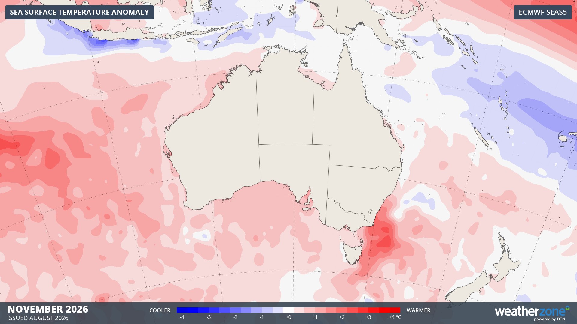
Image: Forecast sea surface temperature anomalies in November 2026 according to the ECMWF SEAS5 model. Source: Weatherzone.
Mixed impacts as El Niño and locally warm oceans interact
The contrasting influences of El Niño and unusually warm water near Australia are already causing mixed weather impacts across the country.
Over the past three months, parts of southern and central Australia experienced winter rainfall in the top 10% of historical records. Some areas in South Australia and New South Wales even had their wettest winter on record.
By contrast, winter rainfall was below average across eastern parts of Queensland, NSW, Victoria and Tasmania, and southwest WA. Parts of all five states registered winter rainfall in the bottom 10% of historical records.
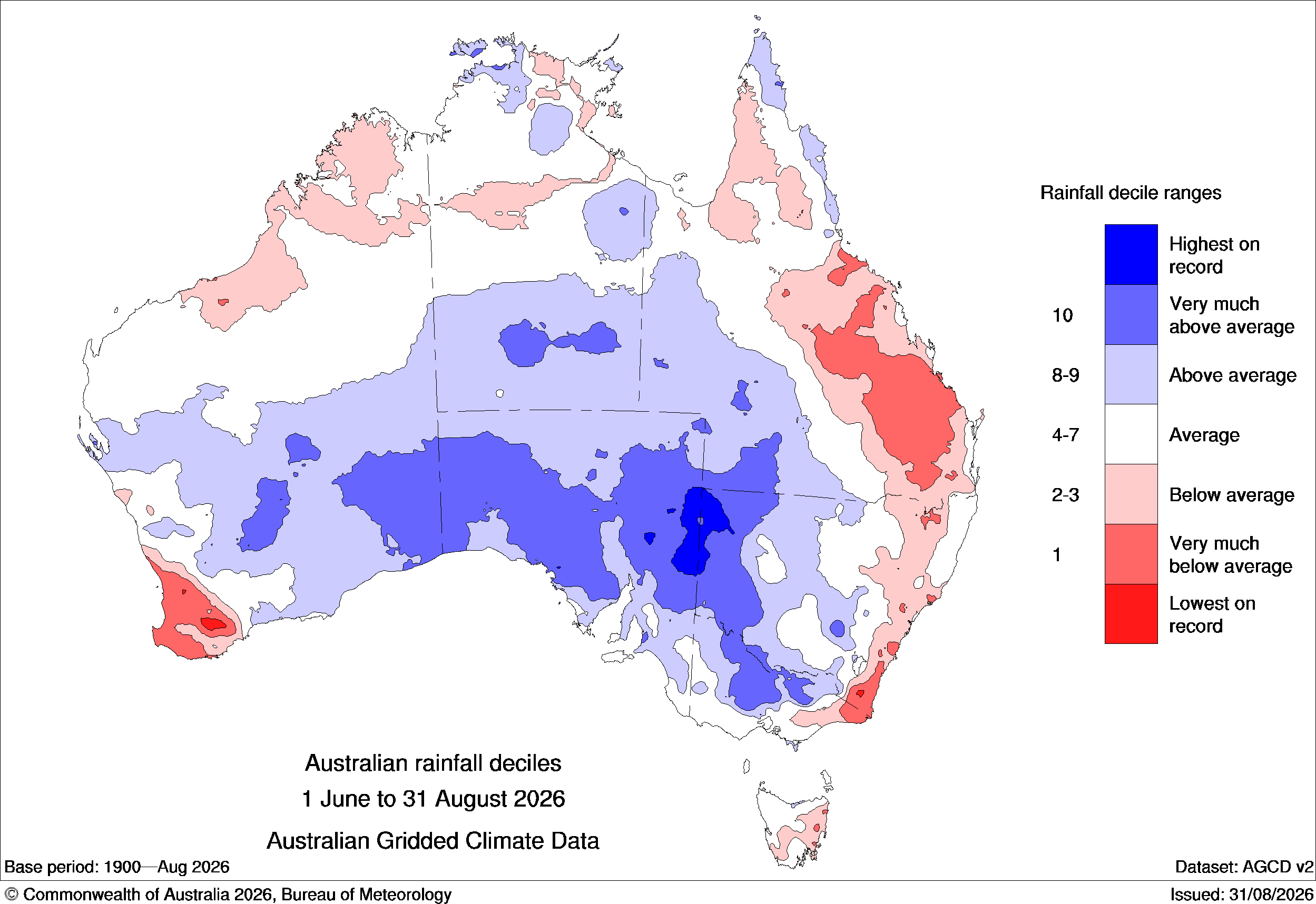
Image: Winter 2026 rainfall deciles, showing a stark contrast between below average (blue) and above average (red) rainfall across the country. Source: Bureau of Meteorology.
Temperatures also showed a strong contrast in winter. Parts of SA, the NT and WA registered near-average maximum temperatures in winter, while temperatures were well above average in eastern and northern Australia. Tasmania, the ACT, and parts of Victoria and NSW had their warmest winter on record based on daytime warmth.
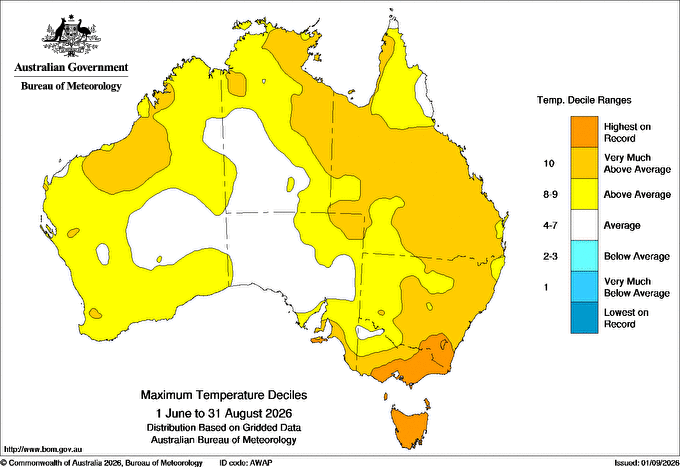
Image: Maximum temperature deciles in winter 2026, showing record-breaking daytime warmth in southeastern Australia. Source: Bureau of Meteorology.
Looking ahead, Australia should continue seeing contrasting weather impacts as El Niño gains strength in the Pacific Ocean and local sea surface temperature anomalies become even more positive to the east and west of the country.
Long-range forecasts from the Bureau show that parts of western, northern and central Australia could see above average rain this spring, while drier than average weather is predicted for southeastern Australia, southwest WA, parts of eastern and northern Queensland and the NT’s Top End.
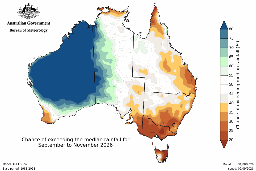
Image: Spring 2026 rainfall outlook according to the Bureau of Meteorology’s ACCESS-S model. Source: Bureau of Meteorology.
This outlook appears to reflect the increasing influence of moisture being sourced from unusually warm water in the Indian Ocean to the west of Australia in the coming months.
Meteorologists will be closely watching the development of El Niño and local sea surface temperatures in the coming months to see how these competing forces will affect Australia’s weather in spring and summer. Close attention will also be paid to the IOD and SAM, which can both help tip the scales towards wetter or drier and warmer or cooler weather.