
Coldest July temps in 56 years in parts of Qld
Queensland has shivered through one of its coldest days in years, with more in store today.
Large parts of the state endured an extremely cold Monday by local standards, with maximum temperatures at some locations the lowest in 56 years for July, and the lowest in almost 17 years for any month.
What's truly remarkable about Queensland's current cold spell is how widespread the chill is.
It's so cold in Brisbane I'm thinking of putting on two pairs of trackies.
— Laminzi🌳🌲ðŸ™ðŸŒðŸ’§ (@annaclarity1) July 4, 2022
You'll occasionally see significant cold temperature anomalies in one part of Queensland – as happened last Friday when parts of the North West forecast district around Mt Isa saw max temps around 15°C below average due to a cloud layer that prevented warming after a cool night.
But as mentioned, yesterday was different. It was bone-chilling virtually right across the state on Monday, with well-below-average maximums recorded from the Darling Downs and Granite Belt, to Brisbane, all the way up the coast to Townsville and Cairns.
A sample of Monday's chilly maximums included:
- Toowoomba 7.6°C (coldest in 11 years)
- Dalby 9.7°C (coldest in 15 years)
- Bundaberg 12°C (coldest in 17 years and coldest July max in 56 years)
- Yeppoon 12.5°C (coldest in 15 years and coldest July day in 28 years of records)
- Gympie 13°C (coldest in 15 years)
- Brisbane 14.2°C (coldest July max in 22 years)
- Lady Elliot Island 14.8°C (coldest in 15 years, and noteworthy as it's the southernmost tiny coral island of the Great Barrier Reef)
- Townsville 15.1°C (coldest in 15 years)
- Cairns 21.4°C (coldest July max in 23 years)
While no all-time low maximum records appear to have been broken, we'd repeat our earlier point that the range of locations experiencing well-below-average max temps is what made Monday remarkable in Queensland.
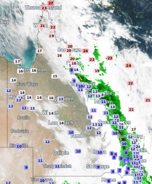
And Tuesday appears to be trending in a similar direction, as you can see above on the satellite image with live temps taken at 10:20 am today.
It's also worth noting that if Brisbane stays colder than 15°C today, it will be the coldest pair of days in 66 years. In July 1956 the city reached only 12.8°C and 14.3°C on back-to-back days.
So what's causing these cold days?
In a word, cloud.
In addition to the temperature observations on the image above, you can also clearly make out the layer of cloud which continues to keep daytime temperatures down. You can also see the active shower activity along the coast, all the way from Coolangatta to Cairns, with numerous stations recording more than 50 mm of rainfall yesterday.
While the national weather focus is understandably on the severe flood situation in New South Wales at present, Queensland is copping some pretty severe wintry weather of its own. A marine wind warning and at least two flood warnings are already in place, and please check our warnings page for more info.