
Beautiful speckled cloud mass over Great Australian Bight
Just look at that beautiful mass of speckled cloud over the Great Australian Bight.
It's the sort of thing you see more frequently in winter than summer, as cold fronts surge northwards towards the Australian mainland.
The reason we're seeing one today is because a wintry airmass is located south of the mainland, which has already delivered Melbourne its coldest day of the year to date yesterday.
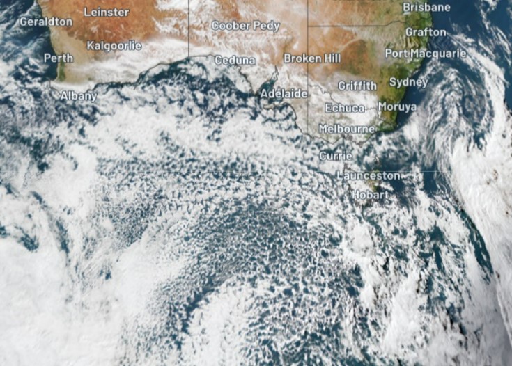
But why is the cloud speckled?
Weatherzone meteorologist Ben Domensino actually wrote a story which referenced speckled air masses a couple of years ago. In it, he explained:
"One of the key features that reveals the polar origin of this air mass is a large field of 'speckled clouds' over the ocean. These clouds form when very cold air moves over a relatively warm area of ocean, causing a large number of individual cumulus clouds to develop over a broad area. Each of these cloud cells can produce rain, hail, snow and thunderstorms, with patches of clear sky in between."
There's a clue in that explanation as to why cities on Australia's southern coastline like Adelaide and Melbourne are famous for experiencing four-seasons-in-a-day type weather in winter quite frequently.
As Ben explains above, each of the cloud cells in a speckled airmass can produce downbursts of precipitation, but there are patches of blue sky in between. When a large speckled airmass reaches mainland Australia, each break of sun means the next shower is inevitably on its way.
The bulk of today's mass of speckled cloud is located well south of Australia. There have been only very light showers in southern SA and Vic with a bit more activity in Tasmania, where light snow is possible in higher areas tonight as the coldest air moves through.
We'll likely see larger, colder air masses penetrate further north in coming months, but this afternoon's satellite image is still a fine sight for all you weather lovers out there – and for snow lovers, hopefully a sign of things to come.