
Australia's west coast shivers while the east coast bakes
There has been a stark temperature contrast between Australia’s west and east coasts this month, with Perth running more than 1°C below average while heat records tumble on the other side of the country.
The southern half of Australia has been stuck under the influence of abnormally strong westerly winds in recent weeks. These stubborn westerlies – which have occurred in response to a rare episode of Sudden Stratospheric Warming above Antarctica – have had a big impact on temperatures.
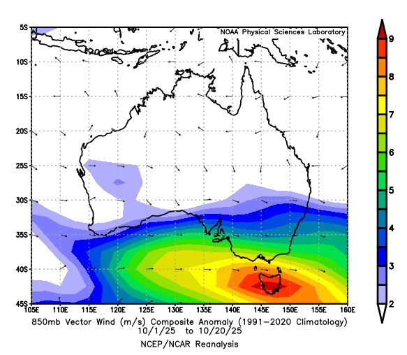
Image: Average 850 hPa wind anomalies during the first 20 days of October 2025. Source: NOAA
Cool in the west
Onshore winds carrying cool air from the Southern Indian Ocean towards southwestern Australia have stifled temperatures along the country’s west coast this month.
Perth’s running average maximum temperature during the first 22 days of the month was 22.2°C, which is about 1.3°C below average for October. The city has also only had one day over 30°C since the start of the month, while an average October usually produces about three days above 30°C.
Rainfall has been healthy in the west this month, with Perth already picking up 41 mm in the last three weeks, slightly above the city’s October average of 39 mm.
Hot in the east
While the country’s west coast has escaped the heat this month, the east coast of Australia has been baking.
The abnormally strong westerly winds flowing across the southern half of Australia this month have caused hot air from the country’s interior to spread towards the east coast.
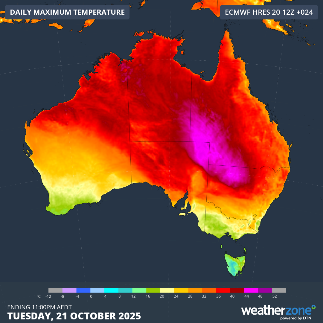
Image: Hot air over central and eastern Australia and milder air over the country’s southwest on Tuesday, October 21, 2025.
Sydney and Brisbane are both on track to have their hottest Octobers on record based on average maximum temperatures.
Sydney has already registered 7 days over 30°C so far this month, which is five more than usual and a new record for October. The city has also only received 5 mm of rain since the start of October, well below the long-term monthly average of 78 mm.
Looking ahead, Perth will continue to see days in the high teens to low twenties for most of the final week of October, with a couple of warmer days early next week. The east coast will stay relatively warm until at least early next week, particularly in Brisbane.
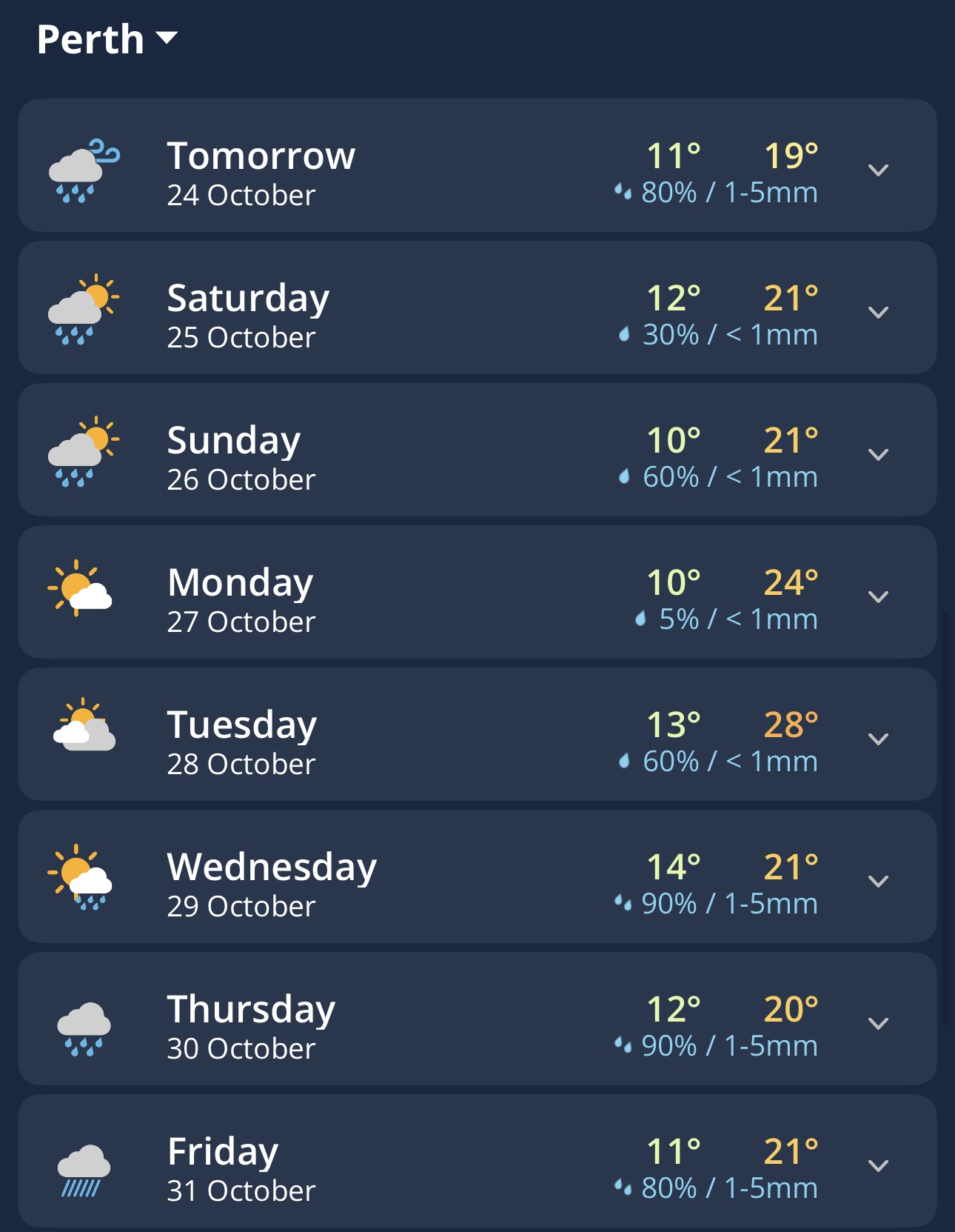
Image: Daily forecasts for Perth in the Weatherzone app.
Here are the forecast maximum temperatures for all three cities over the coming week:
- Thursday 23rd: 21°C
- Friday 24th: 19°C
- Saturday 25th: 21°C
- Sunday 26th: 21°C
- Monday 27th: 24°C
- Tuesday 28th: 28°C
- Wednesday 29th: 21°C
- Thursday 23rd: 22°C
- Friday 24th: 25°C
- Saturday 25th: 25°C
- Sunday 26th: 28°C
- Monday 27th: 26°C
- Tuesday 28th: 19°C
- Wednesday 29th: 31°C
- Thursday 23rd: 34°C
- Friday 24th: 32°C
- Saturday 25th: 28°C
- Sunday 26th: 33°C
- Monday 27th: 36°C
- Tuesday 28th: 26°C
- Wednesday 29th: 27°C