
October temperature records broken in searing Sydney heat
October heat records have been broken across the Sydney basin and further north in the Central Coast and Hunter regions this Wednesday, as strong northwesterly winds funnel scorching hot air from the country’s interior towards the NSW coast.
After a relatively mild morning, the predicted hot air arrived with a rush early in the afternoon, with the mercury at Sydney’s official weather station at Observatory Hill jumping 11 degrees (from 25.9°C to 36.9°C) in the hour between 12:55pm and 1:55pm.
By 3pm, temperatures were in the high 30s across the city, with Observatory Hill having reached 37°C (the October record is 38.2°C).
While the main city weather station hasn’t yet exceeded the old October high mark, records broken so far this Wednesday in and around Sydney include:
- Taree, on the Mid North Coast around 300km north of Sydney, reached a remarkable 41.2°C. Not only did this exceed the old October record by 1.2°C, it was several degrees hotter than any day last summer!
- Bankstown Airport was Sydney’s hottest spot to 3pm, with a high of 39.8°C. That was almost 16 degrees above the October average maximum of 24°C, and narrowly exceeded the old October record of 39.7°C.
- Williamtown, just north of Newcastle, reached 39.6C. The old October record was 39.4 °C in data going back to 1950.
- Penrith in Sydney’s outer west reached 39.5°C. The old October record at the current site with 30 years of records was 38.9°C.
Why so hot across Sydney?
After Monday and Tuesday’s record outback heat near the corner of SA/QLD and NSW, northwesterly winds have pushed the furnace-like airmass in a southeasterly direction
Due to the strong and gusty nature of those winds, there was no hint today of the sea breeze that often leaves Sydney’s coastal suburbs up to 15 degrees cooler than the city’s west on hot summer days.
Uniform heat across Sydney’s suburbs is actually quite a common occurrence during the spring months, especially in years like 2025 when westerly winds dominate the weather pattern in eastern NSW.
Of course, when westerlies are blowing across southeastern Australia, that usually means there’s a cold front lurking somewhere down south, and that is indeed the case this Wednesday.
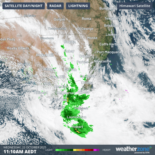
Image: Four-hour combined radar and satellite loop in the late morning and early afternoon of Wednesday, October 22, 2025, over SE Australia.
While Sydney was nearing 40°C on Wednesday afternoon, Melbourne and Adelaide were both struggling to reach 20°C.
The loop above shows a speckled airmass, indicative of frigid air with polar origins, which is moving through the southeast of SA towards Victoria, while Sydney is baked by hot warm air ahead of the cloudband.
Some handy rainfall totals have been recorded across SA, Vic and parts of southern NSW with that rainband, including almost 50mm between midnight and 3:30pm Wednesday at Perisher Valley in the Snowy Mountains of NSW.
While a shower or storm is possible, not much rain is expected to dampen Sydney after today’s extreme heat. This will likely disappoint locals as the city has experienced a rare dry spell in recent weeks with almost no significant rainfall since mid-September and just 4.8mm so far this October.
There will, however, be temperature relief as the hot air moves out to sea overnight, with maximums in the low-to-mid 20s across the city tomorrow.