
Australia, land of contrasts: 48 degrees and snow on the same day
From fireballs to snowballs, Australia is likely to have it all on this first day of the 2020 summer.
The relentless heatwave that has baked much of eastern Australia continues - especially in the area where the SA, Qld and NSW borders intersect, where temperatures at various locations have now hovered in the mid-forties for at least four days.
Bourke in northwest New South Wales, still reeling from extreme late spring heat, is today expected to reach a sizzling 48 degrees.
The town of 1800 residents on the Darling River has the hottest temperature forecast anywhere in Australia this Tuesday, and as you'd expect, fire bans are in force across a wide area of New South Wales.
Hot and windy conditions and Very High to Severe fire danger across most of NSW today. Total Fire Bans are in force across 7 areas including North Western, Northern Slopes, Lower Central West Plains, Central Ranges, Northern Riverina, Eastern Riverina & Southern Riverina. #NSWRFS
— NSW RFS (@NSWRFS) November 30, 2020
Western Sydney will also feel the effects of the hot airmass, with 41 predicted for Penrith, at the foot of the Blue Mountains.
Meanwhile in Australia's southernmost state, it’s a totally different story.
While the day will start with temperatures in the mid 20s in the eastern half of Tasmania under the influence of a warm northerly airstream, rain will develop in most areas, followed by snow above 900 metres overnight.
Mt Wellington in Hobart is 1271m above sea level, so there will likely be a few flakes around for those thinking of undertaking an early morning snow chase to the summit.
It seems like a strange start to summer. So what's happening?
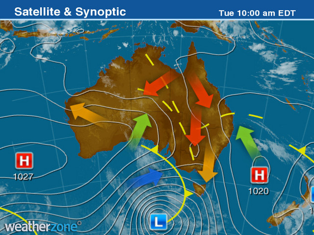
The Tuesday morning synoptic chart clearly shows the hot air streaming down from the north and the cold front looming from the south.
"Late spring and early summer is when we always see the biggest temperature contrasts in Australia," Weatherzone meteorologist Ben Domensino explains.
"At this time of year, we have weather patterns where cold air moves up from the Southern Ocean - which is always still cold at this time of year - and hot air building up over central and northern Australia before the wet season kicks in, and this is a particularly hot air mass for the start of summer.
"When we see those two airmasses crashing into each other, the contrast in temperatures can be quite dramatic."
Heat will persist in parts of northern and eastern Australia throughout this week, with temperatures continuing to reach the low-to-mid forties in multiple states.