
A welcome week of showers for Adelaide, Melbourne, Hobart
Rain, and plenty of it, is heading to Adelaide, Melbourne and Hobart – three Australian capital cities which have all experienced significant rainfall deficits to date in 2025.
Before this week, you could have added Perth to the list of cities that desperately needed a drop, after five consecutive below-average rainfall months to start the year. But things are starting to look up after a wet finish to May and 61.8mm in the first five days of June which included the city's wettest day in 11 months.
Now large parts of southeastern Australia are in line for a good soaking. An approaching cold front will usher in the first round of rain from Friday into Saturday, with a continuation of cold, wet weather into the weekend as a low pressure system centred over Bass Strait pushes more moisture onshore to both Tasmania and the mainland.
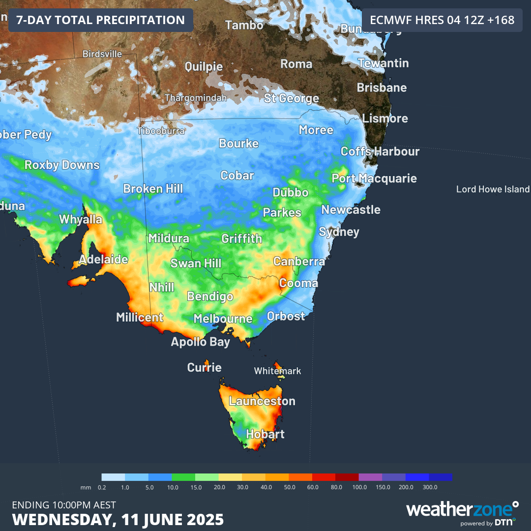
Image: Predicted total rainfall accumulation to Wednesday, June 11, according to the ECMWF model.
Let’s break down the positive news for the parched southeastern capitals, one city at a time.
Adelaide
At least some rain is possible in Adelaide on each of the next six days, beginning Friday. The period from Friday through to Sunday looks the wettest, with a good chance of total falls in the 20-40mm range across those three days.
To date this year, Adelaide has seen just 47mm, so it’s conceivable that the entire year’s rainfall to date could be eclipsed in the coming week. With Adelaide’s combined water storages at just 36%, every drop is needed.
Sunday will also be super chilly in Adelaide. The predicted high of 13°C would make it by far the coldest day of 2025 to date.
Melbourne
Melbourne had a solid start to 2025 in terms of rainfall, with an above-average January followed by February and March totals that were very close to average. But April and May both saw less than half the monthly average, so not too many locals will complain about the coming rain.
The coming weather system is unlikely to send a deluge Melbourne’s way, however it is quite a dynamic system so showers should be persistent over the next six days. The period from Saturday through to Tuesday looks most likely to deliver daily totals of up to 10mm or slightly more.
It will also be cold throughout this period, with a maximum of 13°C (or possibly a degree or two less) expected on Sunday, and maximums no higher than 15°C for the next six days. If you’re going to the Carlton vs Essendon AFL match at the MCG on Sunday evening, rug up!
Hobart
Hobart had four very dry months to start the year, then a wettish May that slightly exceeded the monthly average.
There’s the potential for a shower on Friday and Saturday, but the action really ramps up on the weekend with the potential for total falls of 20-50mm or slightly more from Saturday through to Wednesday.
Due to the position of the low as its centre slowly moves from west to east just north of Tasmania, moist winds will funnel towards the state from different directions at different times – so if your clothes are drying on the back porch one day, don’t assume they’ll be safe the next day!
READ MORE: Polar blast to deliver long weekend snow in Aussie Alps
As for the other southeastern capitals, Canberra tends to see less rain than Adelaide or Melbourne from systems like this due to the rain shadow effect of the mountains to the west of the city. However, some showers are likely from Saturday through to Tuesday.
As for Sydney, it will miss most of the rain, as is also common with cold winter systems like this where the heaviest rain tends to fall west of the divide. While a light shower is possible from Sunday through to Tuesday, the city can enjoy a well-earned break from heavy rain after accumulating 813.2mm in the city’s main gauge so far this year.