
Wintry conditions continue across the UK
Parts of the UK have seen deep snowfall over the last week, especially over portions of northern Scotland, with more snow on the way in the coming days.
Heavy snow for some
Some locations have recorded over 40 cm of snow in the past week, which is the highest amount recorded somewhere in the UK since January 2018. Within these areas, transport has been hampered, severely in places, with some schools also closed.
However, large parts of the UK have received little or no snowfall, as the heaviest snow arrived in the form of showers, which formed over the sea and were driven onto coastal areas exposed to the general northerly flow.
Will there be more snow?
The cold air will remain in place across the UK for the remainder of this week. While the showery flow from the north has been cut-off, a developing area of low pressure over the North Atlantic Ocean is expected to arrive through Thursday and Thursday night. This storm has been named Goretti by Météo-France, the national weather service of France. This is because the storm is expected to bring high winds to northern parts of France.
For the UK, being on the north side of the storm means that the area of precipitation associated with it will be located, in the main, within colder air. This brings the risk of some heavy snowfall, but the devil is in the detail of the path of the storm.
At this stage, the centre of the storm looks like tracking broadly eastwards across the south of the UK. This means southern counties are most likely to have rain, as the less cold air should be in place for much of the time.
The highest risk zone for heavy snow appears to be through portions of Wales, the Midlands, and into parts of eastern England and, perhaps, northern East Anglia. Within this area, 5-10 cm of snow is possible on Thursday night, perhaps 15-20 cm in a few spots, especially over the higher ground. Additionally, the wind will strengthen, bringing the risk of drifting snow, as well as icing to power lines – the latter can lead to power outages.
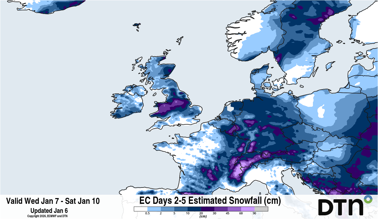
Image: Forecast accumulated snow for the four-day period starting on Wednesday, January 7, 2026. Source: DTN.
As the storm intensifies as it moves eastwards, it may be that heavy precipitation around the back of the storm brings the snow level down across parts of southern England as the storm starts to clear. This could bring a spell of two to three hours of heavy snow and strong winds – this is rather uncertain, though.
As well as the snow risk with this storm, there will be a short but intense spell of strong winds for parts of southwest England, also on the back of the storm. Gusts may reach 60-70 mph across parts of Devon and Cornwall, with the west of Cornwall and the Isles of Scilly possibly seeing gusts of 80-90 mph later on Thursday afternoon through to the middle of the evening. The Channel Islands will also experience these high winds.
Why the storm track matters
What about the statement above about the devil being in the detail of the storm’s path – why does this matter?
A west-east path further north would bring a higher risk of snow to north Wales and parts of northern England, with the Midlands and south Wales seeing a higher chance of rain; conversely, a west-east track through the English Channel would increase the risk of heavy snow for southern parts of England.
Keep up to date with the latest forecasts if you live within, or plan to travel to, these areas on Thursday evening and night, and be prepared for the risk of disruptions.