
Wintry blast sweeps the southeast
As anticipated here yesterday, an intense winter-like cold front barrelled across the southeast of the country, bringing with it a burst of heavy showers, raging winds, large waves, and a solid dose of snowfall to the Alps late yesterday, with winds and large waves continuing into today.
Numerous elevated and exposed coastal locations in Tasmania, Victoria and New South Wales experienced staggering winds late yesterday and during this morning, some of which are the most intense observed in months at certain sites. Wilson's Promontory recorded the highest wind gusts in the country, with a ferocious 137 km/h observed early this morning, marking it the strongest gust registered this year. Tasman Island also encountered a tempestuous blast, clocking in at 126 km/h, which stands as the most powerful gust experienced since last winter.
Additionally, various other locations across TAS, VIC, and NSW reported wind gusts surpassing 80-100 km/h, including Hogan Island with 117 km/h, Kunanyi Mount Wellington with 109 km/h, Maatsuyker Island 106 km/h, Cape Bruny 104 km/h, and Green Cape with 100 km/h.
Although the precipitation totals were not extraordinarily impressive, there were notable amounts recorded until 9 am, primarily concentrated over Victoria and Tasmania. Mount Read (TAS) received a generous 66mm of rain, marking the highest May rainfall in 3 years and the highest overall since winter 2021. Other rainfall totals until 9 am this morning include Ferny Creek (VIC) with 22mm, the highest May rainfall in 4 years, Scotts Peak Dam (TAS) with 28mm, the highest May rainfall in 3 years, and Davey Gorge and Dove River in TAS with 29mm and 23mm respectively, their highest May precipitation in a year.
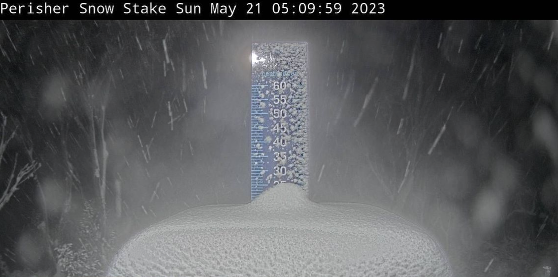
Meanwhile, the Alps were graced with a fresh layer of snow, measuring at least 15-20cm as evidenced by the Perisher snow stake this morning (picture).
While this snowfall may not have been as extraordinary as the winter storms, it was sufficient to ignite the enthusiasm of skiers and snowboarders eagerly anticipating the beginning of the snow season.
In the wake of the cold front, persistent gusty southwest/south winds send chills down the spines of residents throughout the southeast with the current feels-like temperatures, as of writing this story, hovering between 7-11 degrees in Hobart, Melbourne, Canberra, and even Sydney.
As the cold front journeys further eastward and high-pressure systems seize control, the winds will gradually abate late today and into Monday 22nd. Nevertheless, the coastal areas will witness an escalation in wave heights and surf activity. Consequently, a warning of hazardous surf conditions has been issued by the Bureau of Meteorology for parts of New South Wales's coastline, encompassing the Hunter, Illawarra, and Sydney areas. These hazardous conditions may endure until the first half of Monday, posing a threat to the exposed coasts of NSW.
Over the ensuing three days following this episode, colder mornings and nights are anticipated, accompanied by a heightened risk of widespread frost enveloping the southeast. The frosty phenomenon may even extend into the southern reaches of Queensland as the prevailing high-pressure system exert its influence. However, since this is only the dawn of winter, the middle to later part of next week holds even more impactful weather in store. A sequence of robust low-pressure systems looms on the horizon, poised to unleash more significant winds, rainfall, and snow upon the southeast.
To stay informed about these dynamic weather conditions, it is crucial to stay tuned to the weather forecast for the latest updates for this week at https://www.weatherzone.com.au/