
Wintry blast impacting WA
A pre-frontal trough, supplied by a stream of moist air from the Indian Ocean, has deposited appreciable rainfall over southwestern WA.
Some of the most significant falls in the 24 hours to 9am today were 61.2mm on Rottnest Island, 52.6mm at Mandurah and 41.8mm on Garden Island; these figures equate to the heaviest daily rain in about 3 years for Rottnest Island and 2 years for Mandurah.
Impressively, most of this rain fell in just over 12 hours.
A cold front will spread further areas of rain across the region, although the focus of the biggest totals will shift to coastal and adjacent inland areas between Margaret River and Hopetoun, where a further 20-50mm could fall by midday Monday - locally over 80mm.
Meteorologists are keeping a close eye on the possible development of two low pressure systems, most likely about Perth and Albany. These lows are expected to generate some extremely gusty winds overnight tonight for coastal parts of the South West Land Division.
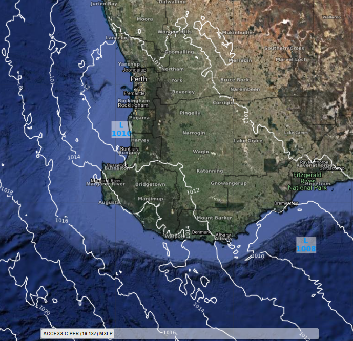
Image: Forecast MSLP according to ACCESS-C over southwest WA tonight; two distinct low centres are apparent near Perth and Albany, with gusty winds expected in their vicinity.
Wind gusts could reach up to 100km/h over some exposed coasts, potentially even higher depending on the evolution of these lows.
A gradual easing in winds is expected for most areas from the middle of Monday as the complex array of systems clears east, although a very cold airmass will spread across the region in a stiff southerly wind.
The cold air will linger through the remainder of the working week and reach as far north as the Pilbara and Northern Interior, with temperatures forecast to be widely below average.