
Winter's done but wet WA still soaking in it
Brett Dutschke
This winter has been a good season rain wise for much of Western Australia's west and south, and spring is off to a wet start with widespread showers.
In the past 24 hours, showers dampened parts of 11 districts, bringing more than five millimetres to parts of 10 of them, and more than 30mm to parts of six districts.
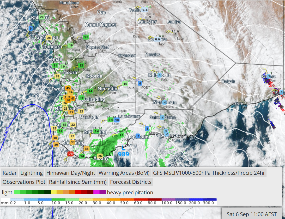
Image: Rainfall observations in 24 hours to 9am Saturday 6 September, radar, satellite, synoptic pattern.
Notable 24-hour rainfall includes -
- 73mm at Windy Harbour
- 49mm at Shannon
- 47mm at Jandakot
- 45mm at both Gingin and Bungendore
- 38mm at Perth Airport
- 36mm at Coondee
Despite this winter being a fairly wet one, the 24 hours to 9am today has seen the highest daily rainfall in -
- 4 years at Windy Harbour
- 2 years at Ingleboure (27mm)
- 15 months at Maida Vale (40mm) and Perth Airport
- 14 months at Lake Nammen (29mm)
- 13 months ar Amelup (28mm)
- 10 months at Canna (25mm) and Shannon
Not only did these and many other locations receive higher daily rainfall than on any day this winter, they haves been unusually wet for September.
It has been the wettest September day in -
- at least 39 years at Cape Leeuwin (39mm) and Windy Harbour
- 30 years at Jandakot
- more than 25 years at Southern Cross (15mm), Shannon, Gingin and Canna
- more than 20 years at Moondah Brook (36mm) and Coondee
- 10-12 years at many other places, including Perth (33mm), Swanbourne (34mm), Lake Grace (14mm), Eradu (26mm) and Morawa (19mm)
We've mentioned this recent rain comes after a wet winter which turned out to be wetter than the long-term norm for most of WA's west and south.
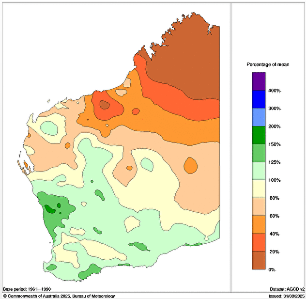
Image: Rainfall received during winter 2025 in WA compared to the seasonal average.
It was the wettest winter in -
- 29 years in Perth (508mm, 110mm more than average)
- 27 years at Wialki South (181mm, 62mm more than average)
- more than 25 years at Coondee (488mm, 285mm more than average)
- 10 years at Southern Cross (163mm, 70mm more than average)
Looking ahead, cold fronts will scatter showers across WA's west and south this Sunday/Monday and next Saturday/Sunday, although falls will be less widespread and less plentiful.
Ideally, grain farmers in WA's South West Land Division would prefer it to gradually dry out and warm up gradually as spring progesses, in order for healthy winter crops to flourish. Other weather features they'd prefer to stay well away are intense hail, wind and late-season frost, all of which have damaged crops in recent years. Whilst intense hail and wind are unlikely in the next week or so, they cannot be ruled out later on. Keep up to date with the forecasts on weatherzone.com.au/wa
Note to media: You are welcome to republish text from the above news article as direct quotes from Weatherzone. When doing so, please reference www.weatherzone.com.au in the credit.