Where is La Nina?
Australia has been under a La Niña Alert for more than a month and the U.S. officially declared La Niña a month ago. So, why hasn't the Bureau of Meteorology officially declared La Niña yet?
The Pacific Ocean has been showing signs of a developing La Niña since the middle of this year. As this pattern matured, the Bureau of Meteorology issued a La Niña Watch in mid-September and upgraded this to a La Niña Alert in mid-October.
It's now mid-November and many people expected that we would have had a fully-fledged La Niña declared by now.
So, what's going on?
At the end of October, the central and eastern equatorial Pacific Ocean cooled to La Niña levels and the atmosphere above the Pacific was also in a La Niña state.
However, the indices that measure the ocean and atmosphere in the equatorial Pacific have both weakened below La Niña thresholds in the past fortnight.

Image: Observed Sea surface temperature anomalies in the Pacific Ocean on November 15, 2021, showing a distinct La Niña-like pattern. Source: NOAA NESDIS
This slight weakening in the La Niña signal has prevented the Bureau of Meteorology from being able to officially declare that La Niña is underway.
However, this is just a technicality and the developing La Niña is already impacting Australia, and will continue to do so this summer.
Wet start to November
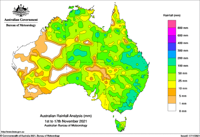
The first half of November has been exceptionally wet over large areas of central and eastern Australia.
The map below shows how much rain fell over Australia during the first 17 days of November. Parts of central and southern Australia have already quadrupled their monthly average rainfall, with some places enduring record-breaking falls.

Image: Observed rainfall during first 17 days of November. Source: Bureau of Meteorology
One rain gauge at Samual Hill in central Qld received a whopping 340.8 mm of rain in 24 hours in the middle of last week.
In NSW, this month's rain has inundated some catchments and caused major flooding in the state's Central West. This is likely to be the wettest November in record for some parts of Australia.
This month's widespread and heavy rainfall is a classic footprint of La Niña and a sign that Australia is already feeling the effects of the La Niña-like state of the Pacific Ocean.
Wet summer still likely
In addition to the above average spring rainfall, a wet summer remains on the forecast for Australia.
Despite the delay, La Niña is still forecast to develop by most climate models from November through until at least February next year.
La Niña typically brings above average rainfall to much of Australia, particularly the north and the east.

Image: Seasonal rainfall outlook for summer (December to February), with above-average rain likely for much of eastern Australia.
In addition to generally above-average rain, heavy rainfall events are also likely to continue into summer with La Niña in the mix.
We will continue to update you on the progress of La Niña and its influence on Australia's weather in the coming weeks and months.