
What makes an East Coast Low a 'bomb cyclone'?
The terms 'East Coast Low' and 'bomb cyclone' are making news headlines in Australia this week as severe weather batters parts of eastern NSW. So, what are these weather systems and what makes them so dangerous for people being impacted by their ferocious weather?
What is an East Coast Low?
Australia’s east coast is affected by various types of low pressure systems every year. However, the most dangerous weather typically comes from a particularly intense breed of low pressure system called an East Coast Low.
The term East Coast Low refers to an intense non-tropical low pressure system that remains in close proximity to Australia’s east coast for a prolonged period of time, causing multiple modes of severe weather.
There are numerous technical aspects of East Coast Lows that distinguish them from other types of low pressure systems in eastern Australia. In general, East Coast Lows:
- Sit close to Australia's east coast (within 200km) for more than 12 hours.
- Have a steep pressure gradient surrounding their centre.
- Cause severe weather, usually including damaging winds, heavy rain and dangerous surf.
What is a ‘bomb cyclone’?
The term 'bomb cyclone' refers to a low pressure system that intensifies rapidly over a relatively short period of time. This process is called ‘explosive cyclogenesis’, also known as ‘explosive bombogenesis’ and sometimes referred to as a ‘bomb low’, ‘bombing low’, or ‘bomb cyclone’.
Explosive cyclogenesis happens when the central pressure of a low drops by a defined threshold within 24 hours. The pressure threshold varies depending on latitude (how far north or south the low is located).
Around Sydney's latitudes, a pressure drop of at least 15 hectopascals (hPa) in 24 hours is required for explosive cyclogenesis. The maps below show that a low pressure system underwent explosive cyclogenesis near the NSW coast this week, with its central pressure dropping by 24 hPa in 24 hours.
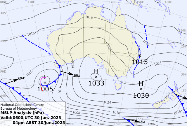
Image: Mean sea level pressure analysis chart for 4pm AEST on June 30, showing a low pressure system near the NSW coast with a central pressure of 1015 hPa. Source: Bureau of Meteorology.
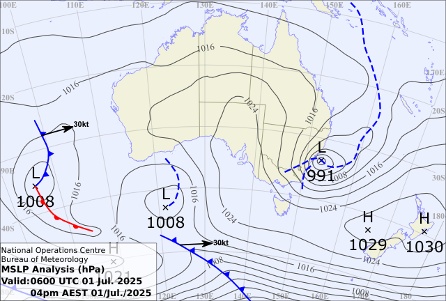
Image: Mean sea level pressure analysis chart for 4pm AEST on July 1, showing a low pressure system near the NSW coast with a central pressure of 991 hPa. Source: Bureau of Meteorology.
Are all East Coast Lows bomb cyclones?
Not always but they often are. Some East Coast Lows form when tropical cyclones move south and transition from tropical to extra-tropical low pressure systems. In these cases, the central pressure may not drop enough to be classified as bomb cyclone, but they are still intense and dangerous.
When a low pressure trough forms near the coast of NSW or southeast Qld and rapidly deepens into an ECL, this usually involves explosive cyclogenesis. East Coast Lows that are also bomb cyclones typically cause a more sudden onset of severe weather.
Are bomb cyclones rare?
Not really. Bomb cyclones can be found in many parts of our planet from the tropics to the polar regions. Australia has already seen about six to eight bomb cyclones since March this year, but most of these have occurred out over sea away from the coast.
It is rarer for explosive cyclogenesis to occur within close proximity to Australia’s coast and when it does, the severe weather can be particularly dangerous because it intensifies quickly.
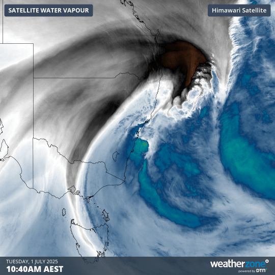
Image: Enhanced water vapour satellite images showing a low pressure system intensifying near the NSW coast on Tuesday, July 1, 2025.
How can I stay safe?
If you are in an area that is impacted by an East Coast Low or bomb cyclone, you should follow advice from local emergency services and monitor severe weather warnings for information on the expected impacts.
The main weather threats from these intense low pressure systems are heavy rain, flooding, damaging to destructive winds and dangerous surf.