
What is a nor'easter and why are they so dangerous?
A powerful nor’easter caused heavy snow, strong winds and huge waves in the Northeastern United States earlier this week. But what is a nor’easter and how can you stay safe when one strikes?
What is a nor’easter?
In the U.S., a nor’easter is defined as a storm that moves along the East Coast of North America, named for winds that typically come from the northeast.
Though these storms can happen throughout the year, they are most frequent, and strongest, between September and April, typically gaining maximum intensity off the Northeastern U.S. and the Maritime Provinces of Canada.
Nor’easters are known to bring huge amounts of precipitation, usually in the form of heavy rain or snow, as well as gale force winds, rough seas, and occasionally coastal flooding.
Nor’easters are unique in how and where they form, with their strong winds and high levels of moisture making them distinct from other types of non-tropical storm systems.
How do nor’easters form?
Nor’easters are produced by areas of low pressure that usually develop between 35°N to 40°N, usually within 100 miles east or west of the U.S. East Coast.
During winter, the polar jet stream transports cold Arctic air southward across the plains of Canada and the United States, then eastward toward the Atlantic Ocean where warm air from the Gulf and the Atlantic tries to move northward.
The warm waters of the Gulf Stream help keep the coastal waters relatively mild during the winter, which in turn helps warm the cold winter air over the water. This difference in temperature between the warm air over the water and cold Arctic air over the land is the fuel that feeds the nor’easter formation.
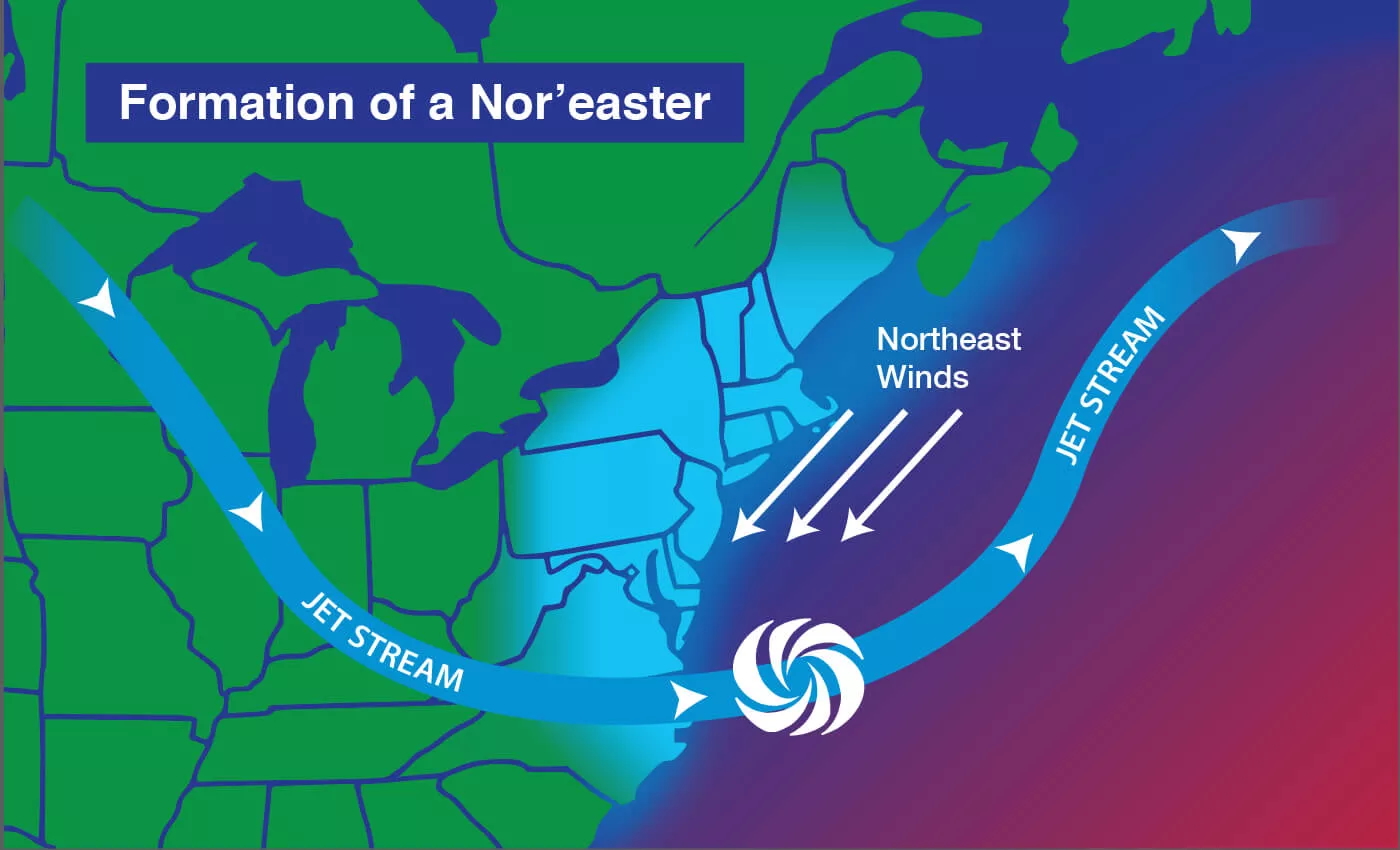
Image: Typical jet stream pattern associated with a nor’easter. Source: NOAA/JPL-Caltech.
Is a nor’easter just a ‘winter’ hurricane?
No, nor’easters and hurricanes are two different types of storms, though they can look very similar on satellite.
Though both storms form over the Atlantic and tend to show up as spiral patterns on satellite images, the way they form is different. Hurricanes form over warm, tropical water, near the equator. The low pressure systems that cause nor’easters form further north, over cooler water. Nor’easters thrive with cooler water and air temperatures, whereas hurricanes need the warmer water to sustain themselves.
Famous nor’easter Examples
Past nor’easters have been responsible for severe economic, transportation and human disruption, and in some cases, disastrous coastal flooding. Damage from the worst storms can exceed a billion dollars.
Some well-known nor’easters include:
- The notorious Blizzard of 1888 which brought 10-58 inches of snow over portions of the Northeast, mostly from the Chesapeake Bay through Maine.
- The “Ash Wednesday” storm of March 1962, which lasted three days and caused significant flooding and even brought snow to parts of the Southeastern US.
- The New England Blizzard of February 1978 that brought 25-30 inches of snow to portions of Boston.
Most recently, a blizzard has impacted the Northeastern US earlier this week, bringing high amounts of snow and gusty winds to the region. This event, rightfully labeled a ‘blizzard’ was also a nor’easter. Snow totals in portions of the New England region and the Northeast US ranged from 21-38 inches for some locations. This large amount of snow combined with sustained wind speeds exceeding 30-35mph, with some gusts up to 60-65mph. Closer to the coast, waves reached up to 10-15ft. These conditions caused travel issues and power outages across the region.
How to stay safe during a nor’easter
Like most winter weather-related storms, having an emergency kit and being prepared for power outages are important steps in being prepared for a nor’easter.
With high snow totals, it can take more than one day to clear streets and sidewalks, making it hard to go anywhere during and after the storm.
In coastal areas, it is also important to be prepared for any flooding that may be possible during the storm.
When a nor’easter is underway, avoid travel, and make sure to have a way to keep up with current weather alerts and warnings.