
What is a heat low and why don't they bring much rain?
Most of us tend to look at low pressure systems on a weather chart and go, "That means rain!"
But not all lows are alike. In summer in Australia, you tend to see a lot of heat lows, or thermal lows as they are also known, especially up in northern parts of the country. These lows work differently to the low pressure systems familiar to the majority of Australians who live in the temperate zone further south.
So what is a heat low?
Take a look at this synoptic chart from Christmas Eve. There would quite likely be similar charts on many summer days, but this is as good an example as any.
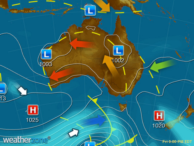
Let's work with the example of the low in WA, about halfway up the coast in the state's Gascoyne region.
That heat low is all about hot air, not rain, and here's why.
As you can see on the chart above, the air pushing towards that low is extremely hot, dry air from inland parts, as indicated by the red arrows. Indeed it is hot airmasses that cause heat lows like this to form.
- Heat lows generally form where there is hot air building up over a landmass.
- That hot air rises, and lifts so much air from the surface that you’re left with a lower pressure at ground level.
- It really is that simple!
So how does a heat low differ from the type of low that typically brings rain?
In southern and eastern Australia, at the opposite end of the country to that northwest WA heat low, we often talk about cut-off lows, east coast lows or just plain old lows.
- Without going into the specifics of each, they are all caused by two contrasting airmasses interacting with each other.
- When hot air from the north meets cooler air from south, that contrast causes warmer air to lift above the colder air along a frontal boundary or cold front.
- So in simple terms, most lows are formed by the contrast between two air masses, whereas heat lows form over an area with the same airmass (where there is intense heating at the surface).
So that's it, in a very brief summary. Long story short, you can often see numerous lows on an Australian synoptic chart in summer - especially over the hotter parts of Western Australia - but you should resist the assumption that they'll bring rain, because heat lows usually don't.