
What happened to La Nina?
La Niña has been underway in the Pacific Ocean since September and continues to gain strength. This usually causes rain to increase over Australia. So, why has November been so dry?
First, a quick refresher about La Niña.
The name La Niña refers to a distinct pattern of abnormal sea surface temperatures and winds across the equatorial Pacific Ocean.
When the La Niña pattern is occurring, it causes more moisture-laden air to travel towards Australia, increasing the likelihood of rain across large parts of the country.
La Niña events last for months, typically forming around autumn and decaying in late summer.
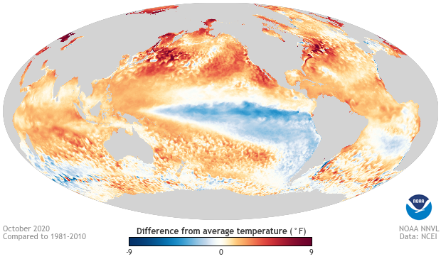
Image: Sea surface temperature anomaly during October 2020, showing a classic La Niña pattern in the Pacific Ocean. Source: NOAA / NCEI
October was the first full month to be affected by this year's La Niña event, making it a late-bloomer. Unsurprisingly this produced one of Australia's wettest Octobe's of the last decade and the wettest in 10 years for NSW, Victoria and SA.
By contrast, November has been remarkably dry for a La Niña month. Large areas of Australia have received less than 20 per cent of their average November rain, despite already being 19 days into the month. This November dryness has been particularly obvious in the north and east, which is where La Niña typically gives the biggest boost to rainfall.
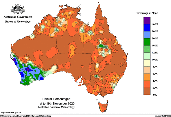
Image: Percentage of total November rainfall observed during the first 19 days of the month. Source: Bureau of Meteorology
So what's going on?
While La Niña increases the likelihood of above-average rainfall in large areas of Australia, it doesn't guarantee it every month.
There are many more ingredients that go into producing Australia's day-to-day weather than just the state of the Pacific Ocean.
While La Niña has been sending more moisture-laden air towards Australia in recent weeks, there has been a distinct lack of rain-bearing systems to convert this airborne-moisture to actual rain during November.
One of the reasons for this has been unusually strong upper-level ridges near southeastern Australia, which have prevented cold fronts from moving up over the eastern half of the country. Instead, these rain-bearing fronts have been hitting the southwest and then dropping down into the Southern Ocean.
The result of this abnormal synoptic pattern has been prolific rain in southwestern Australia and not much rain elsewhere.
Perth is already having its wettest November in records dating back to 1876, with 84mm in the gauge so far this month. Further east, Melbourne has only had 8mm, which is its driest November-to-date in 11 years and well below the monthly average of 60.3mm.
Looking ahead, there aren't any signs of widespread heavy rain in Australia during the next week. There will be a burst of rain and storms over southern and eastern Australia between this coming Sunday and Tuesday, but it will be brief.
In the tropics, monsoonal rain and the first tropical cyclone of the season are likely still several weeks away as well.
As we head into the start of summer, the background influence of La Niña will still raise the likelihood of above-average rain in Australia, despite the predominantly dry weather in November. We just need a favourable synoptic pattern to line up over our part of the southern hemisphere to deliver the rain, which is likely to happen eventually.