
Wet weather giving way to fire weather in the southeast
After what has been a long run of cool, wet weather in Australia’s southeast, hot temperatures and dry winds are now bringing increased fire danger.
A high pressure system firmly over the Tasman Sea is combining with a relatively dry trough over central Australia, resulting in hot and dry winds, mainly from the north. The hot and dry conditions are leading to very elevated fire danger in parts of SA, southern NSW, Victoria and Tasmania, peaking on Monday as the trough crosses the region.
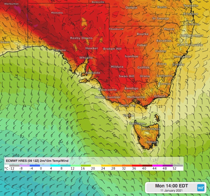 Image: surface temperatures, and wind speed and direction, on Monday afternoon using the ECMWF model.
Total fire bans are in place for most southeastern SA districts, including Adelaide, as temperatures rise to the high-thirties and low-forties with a dangerous wind change during the day. In Victoria, total fire bans are in place for the Mallee, Wimmera and Northern Country districts in high temperatures and dry, gusty winds. Parts of Tasmania are set for their worst fire weather in 12 months, including Hobart. Elevated fire danger is likely and total fire bans a chance in southern NSW, particularly the Riverina district.
A reprieve in the high temperatures and fire danger is likely on Tuesday following a cool change. However, come Wednesday, high temperatures will return to parts of the southeast, elevating fire danger once again.