
Wet start to August after 2nd-driest July on record in southwest WA
A wet spell is imminent for the first full week of August across the southwest of Western Australia, including Perth, after the region’s 2nd-driest July on record.
Let’s break down the unseasonably dry month which has just occurred in the southwest before taking a look at the wet weather coming this week.
Southwest receives only 37% of monthly average rainfall
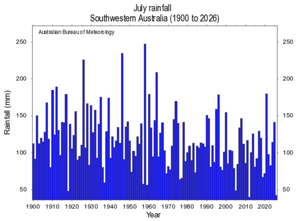
Image: July rainfall in the southwest of Australia from 1900 to 2026. Source: BoM.
The graph above paints a stark picture:
- It shows that in July 2026, the southwest received only 42.05 mm of rainfall averaged across the region.
- That made it the 2nd-lowest rainfall total on record after 2012, when the area average was 39.98 mm.
- The July average over 30 years from 1961-1990 was 112.9 mm (the BoM, in accordance with World Meteorological Organization guidelines, uses a 30-year period as its baseline).
- This year’s 42.05 mm was just 37.2% of the long-term average rainfall for southwest WA.
The chart below illustrates the situation in more visual terms. As you can see, southwest WA was almost completely shaded with pink (below average rainfall) and red (very much below average), and there was even a small patch of dark red (lowest on record).
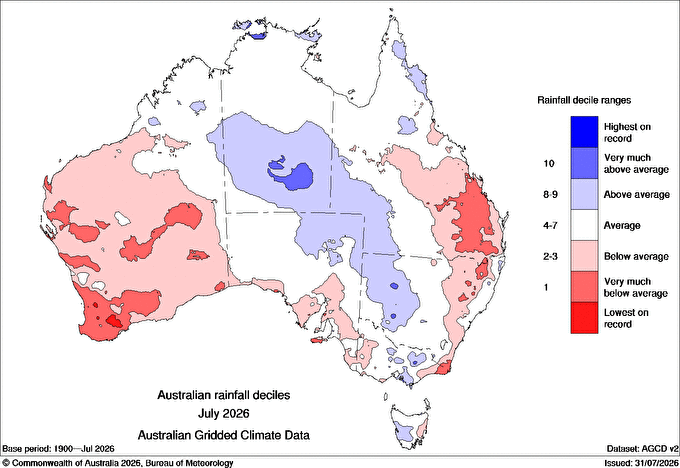
Image: Rainfall deciles across Australia in July 2026. Source: BoM.
One example of a major population centre with record-low July rainfall was Albany, where the monthly total for July 2026 of 50.9 mm was a new record, falling just short of the previous low of 52.1 mm in 1881.
Why was July so dry?
In the big picture, it is widely understood that the southwest corner of Western Australia is being strongly affected by the changing climate, with rainfall declining consistently in recent decades.
Even just the last four years, as illustrated in the chart below, present a picture which is representative of the broader drying trend.
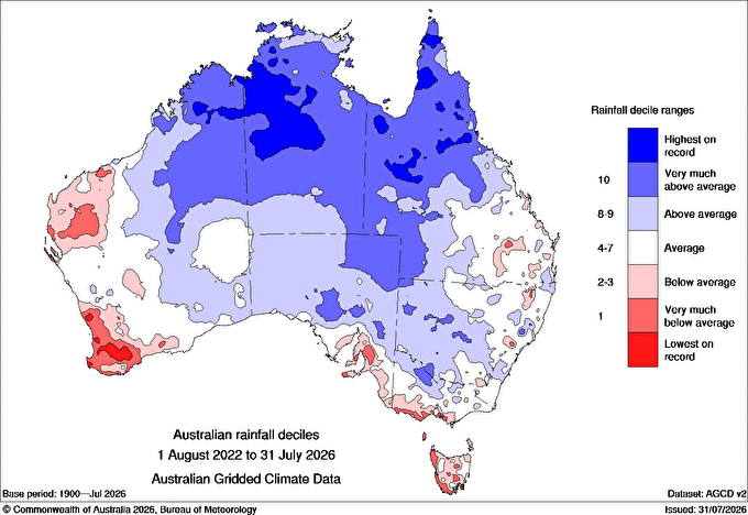
Image: Australian rainfall deciles in the four-year period from August 2022 to July 2026. Source: BoM.
But there were factors behind the dry July which were relevant to current weather patterns too.
The most significant was the strongly positive Southern Annular Mode (SAM), which meant that the band of westerlies, with its rain-producing cold fronts, was further south towards Antarctica than is usual for this time of year.
READ MORE: What is the Southern Annular Mode (SAM) and how does it affect Australia?
But the SAM has since return to a neutral phase after briefly dipping into negative territory last week, which means an increased likelihood of rain events across the southwest. And right on cue, two relatively wet systems are due this week.
How much rain can the southwest expect this week?
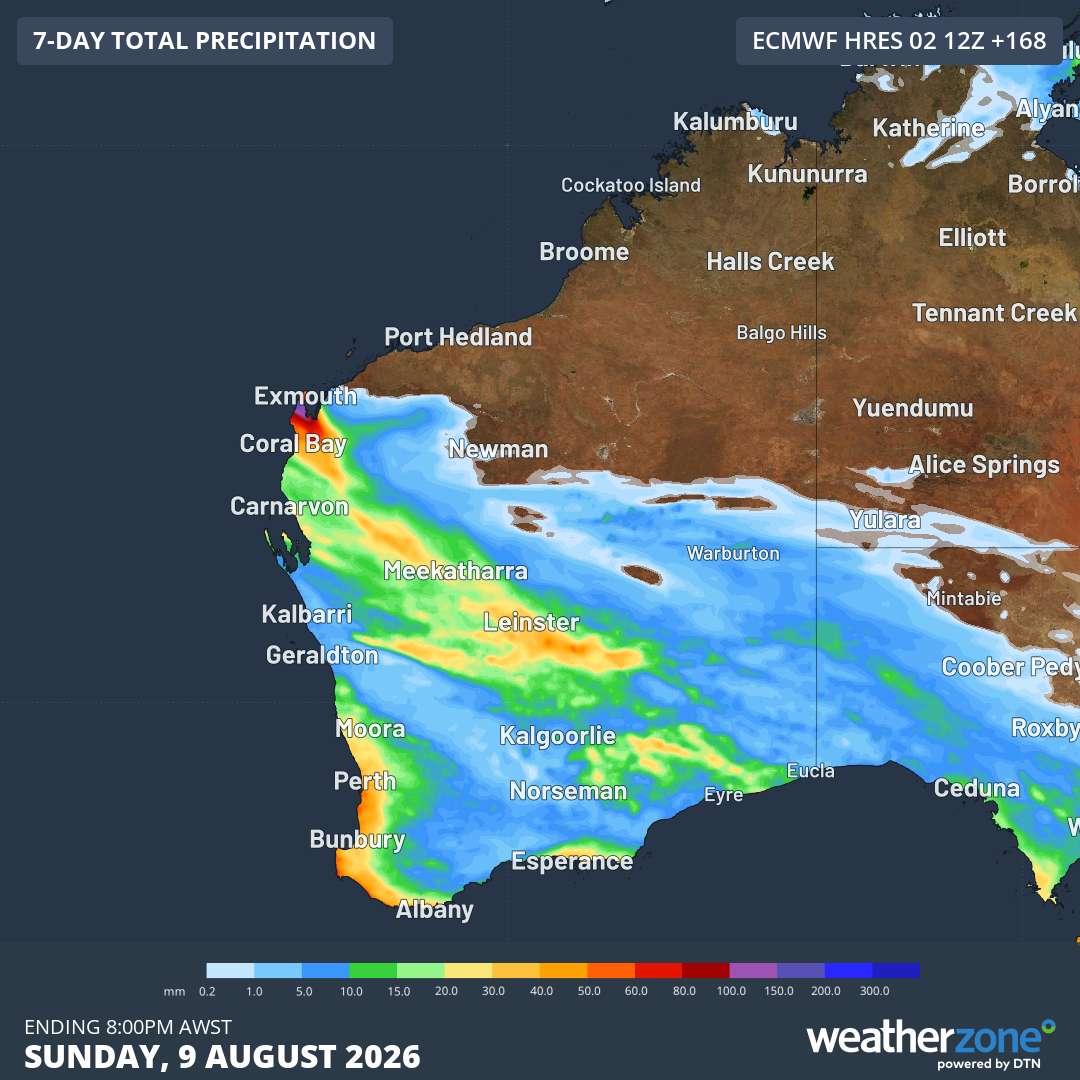
Image: Rainfall predicted for Western Australia up until 8 pm (AWST) on Sunday, August 9, 2026, according to the ECMWF model. Source: Weatherzone.
Two distinct cold fronts are expected to arrive in the southwest this week.
The first front is due later this Monday, with Perth expecting a decent drop of around 5 to 10 mm by the end of Tuesday.
There’s also a trough over parts of the Gascoyne and Pilbara this Monday which will create some unseasonably heavy rainfall in those areas today as moist air feeds in from the northwest.
Wednesday sees a brief window of drier weather for Perth (although places like Albany and Margaret River will continue to see showers) before another front arrives on Thursday. That second system could potentially be a little wetter for Perth and much of the South West Land Division.