
Western Australia's tap turning on after lengthy dry
Most towns in Western Australia's west have a chance to gain some rainfall each day for a week, a big turnaround from the past few months.
Some residents would have trouble remembering the last time they received some rain several days in a row. Others will tell you it was October, a few might say July.
This week's rainfall, largely coming down in showers and thunderstorms, with help from moisture drawn in by Ex-Tropical Cyclone Charlotte. This moisture will continue feeding a near-stationary low-pressure trough over the region.
The areas most likely to gain some form of rainfall each day for at least five days are inland parts of the Central Wheat Belt, Central West and Gascoyne where it has the potential to amount to more than 100 millimetres.
Even the west coast, including Carnarvon, Geraldton, Perth and Bunbury have a chance to pick up more than 20mm during the week, more rain than they received all summer. Perth had its driest summer in eight years and the city's dam levels have dropped below 50 percent capacity.
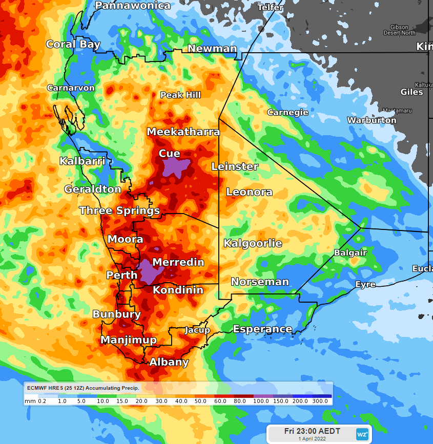
One possible outcome (ECMWF model) regarding rainfall accumulation for the 7 days until Friday evening on 1st April.
The showers and thunderstorms have already begun and have been a long time coming. Even modest totals of under 10mm have been the highest in several months, an indication of how dry the ground is. Rainfall in the 24 hours to 9am Saturday was the heaviest in five months for Collie (10mm), Jurien Bay (8mm), Busselton (5mm), Geraldton (4mm), 4 months in Bridgetown (5mm), Mandurah (3mm), Gingin (3mm), and three months for Perth (2mm). Some of the bigger falls (15-35mm) occurred in the Central West inland where Coolangatta (31mm) and Tenindewa (33mm) had their biggest rainfall in 12 months.
Being so dry recently, this rain will be generally welcome. However, some storms are expected to deliver the rain in a hurry, leading to some flash flooding. Watch out for the warnings including updates of https://weatherzone.com.au/warning.jsp?id=IDW21033