
Welcome March rain may not be enough to overcome drought
A very active weather pattern will continue across the United States this week and extend through next week as well. Drought reduction is likely from this system, but rainfall deficits may be too large to overcome during this pattern alone.
Drought gripping Southern U.S.
Large areas of widespread D2-D4 drought exist across much of the Southern U.S. from eastern Arizona through the Carolinas and Florida. Additional streaks exist from Utah to Nebraska and from Missouri through northwest Ohio. Yet more patches exist in the Pacific Northwest and into the Northeast. As of February 24, 51% of the Continental U.S. was in drought (D1-D4).
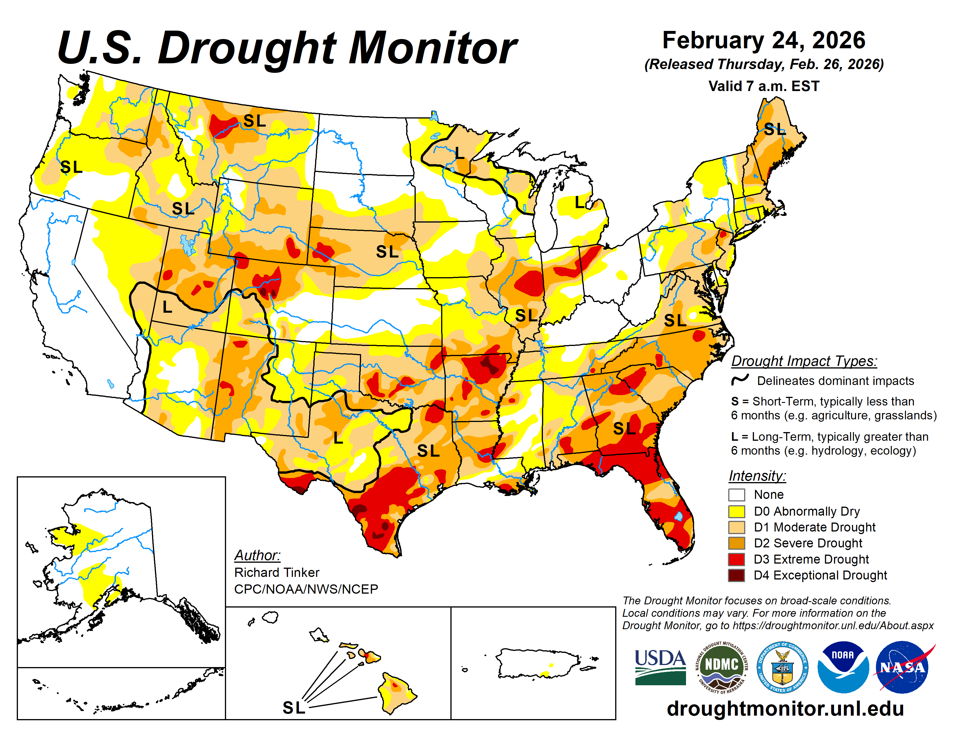
Image: Widespread drought exists across much of the U.S. heading into spring. Source: USDA/NOAA.
The weather pattern for the first two weeks of March is certainly looking quite busy, with almost continuous precipitation over the middle of the country this week, and a couple of larger storm systems being possible next week. But the rainfall deficits to overcome are large, and this current pattern will not be able to erase it all.
Wet start to March
Pockets of heavy rain have already fallen from eastern Kansas and northern Arkansas through Missouri into southern Illinois as of the morning of Mar. 3. Northern Utah and southern Wyoming have also cashed in on some heavier precipitation as well. Amounts around or over an inch have been recorded in both regions.
The busy pattern is forecast to continue across the middle of the country all week, culminating in a larger system that will move through the country between Friday and Sunday, Mar. 6-8 that will produce some widespread precipitation.
When put together, the heaviest precipitation looks to occur from eastern Texas and Oklahoma northeast into Missouri, then just north of the Ohio River from southern Illinois through Pennsylvania into southern New England. Forecasts generally agree on two-to-four inches of rainfall over this period.
A secondary heavier band of near an inch or so may be possible with the final system on Friday into Saturday from Wyoming through Nebraska and into southern Minnesota. Both of these zones are dealing with widespread drought and will gladly take the rainfall.
Next week, two storm systems are likely to move through the country, bringing through some heavier precipitation for the middle of the country with a storm midweek, and with potential for more moderate precipitation later next week with a system moving across the north. The forecast for next week is a little more uncertain, however.
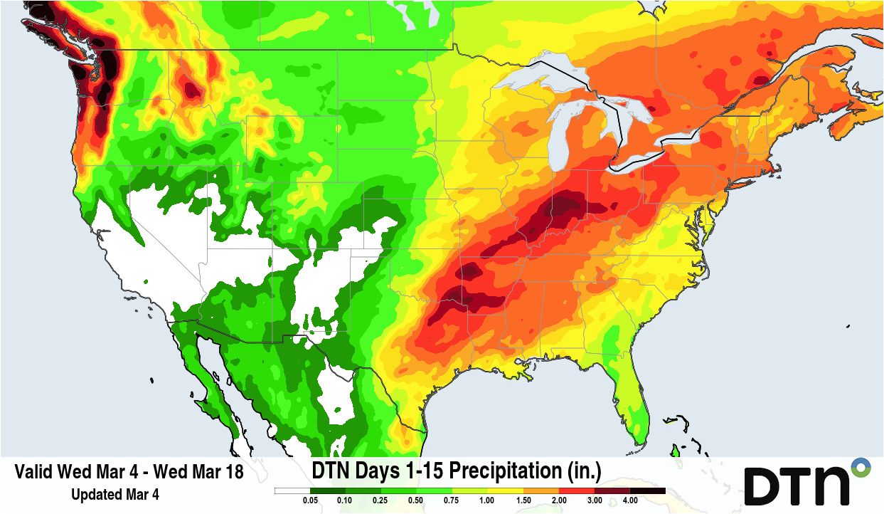
Image: Over the next two weeks, widespread heavy precipitation is in the forecast, particularly from the Southeastern Plains through the Midwest. Source: DTN.
Will this rain break the drought?
While this month’s rain will be welcome for many in the coming weeks, significant rainfall deficits are running higher than the forecast precipitation.
The current 60-day rainfall deficits are running between three-to-six inches below normal from the southeastern Plains through the Ohio Valley, and around an inch or a little more from southern Wyoming through southwestern Minnesota.
The Southeast is also facing similarly large deficits, but without much rain being forecast outside of the front finally moving through the region on Saturday and Sunday, Mar. 7-8. The systems moving through next week could add some more rain, although amounts are looking to run around an inch or less for each event. They will also be spotty and are not forecast to produce much precipitation down to the Gulf or Florida, where some deficits are running more than six inches below normal.
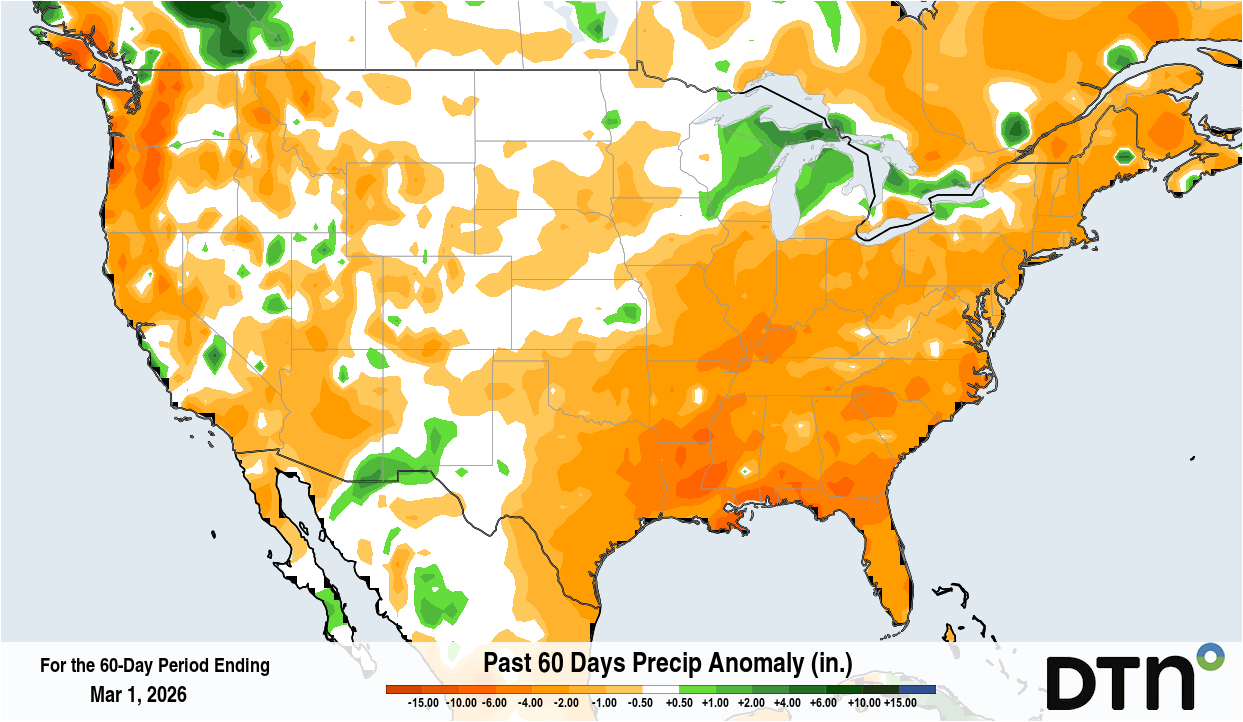
Image: 60-day rainfall deficits over the U.S. up to March 1, 2026. Source: DTN.
We will see major reductions in drought for those areas that are hardest hit, and some flooding may result as well. But wholesale elimination of drought does not appear likely outside of a few lucky spots that have had better precipitation during the winter, like around western Kentucky and through Tennessee and northern Alabama. Southeastern Kansas and parts of Missouri could also see drought be eliminated. But large-scale, lasting reductions in drought are going to take more than this week’s worth of rain.
For some areas, the deficits are larger over extended periods. Some areas in the south-central U.S., including much of Louisiana, Arkansas, and the surrounding areas, are running 90-day deficits of six-to-ten inches below normal. Even adding the rainfall from both this week and next together will not overcome these deficits.
The active weather pattern would need to continue to significantly reduce this drought. In some areas, like the southwestern Plains, or Florida, where the pattern does not favor much precipitation at all, drought may even grow or deepen in the coming weeks.