
Warragamba Dam releasing close to one Sydney Harbour per day
Around 90 percent of Sydney Harbour's volume is currently being released through Warragamba Dam per day, and this rate could increase as heavy rain continues.
Sydney's water storage dams are just some of the catchments in eastern NSW that have been inundated by persistent and heavy rain over the last few days.
#NSWRFS aviation crew continue to assist @NSWSES where required. This video was taken by one of our Air Observers on approach to Taree. For emergency assistance with flood and storm damage call the #NSWSES on 132 500. If it's a life-threatening emergency, call Triple Zero (000). pic.twitter.com/lKu4YlV6To
— NSW RFS (@NSWRFS) March 21, 2021
Moisture-laden air feeding into a near-stationary low pressure trough has caused a relentless steam of rain and thunderstorms over eastern NSW since about Thursday last week.
Some places haven't had any reprieve from the wet weather for around four days, with accumulated totals now edging close to a metre in some places.
A rain gauge at Comboyne Public School, located to the southwest of Port Macquarie, collected 120mm during the six hours between 9am and 3pm on Sunday. This brought the site's running total since 9am last Thursday to 801mm. That's over 80cm of rain in less than four days. Another rain gauge at Comboyne Public School registered 808mm during the same 78-hour period.
In response to this relentless rain, moderate to major flooding has been persisting in a number of river systems from the Mid North Coast down to Sydney on Sunday. This included major flooding at North Richmond.
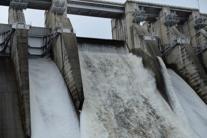
Image: Warragamba Dam started spilling on Saturday afternoon and flows through its spillway have been increasing over the weekend. Source: WaterNSW
According to Water NSW, "Warragamba Dam spillway is currently releasing water at a rate of 450 gigalitres per day (GL/day) and that rate could increase as inflows to the dam storage continue to rise.
"Current projections indicate that this weather event could result in flooding similar in scale to the 1961 flood."
For perspective, the volume of Sydney Harbour is about 500 gigalitres.
Looking ahead, another injection of moisture from the tropics will fuel more widespread rain and thunderstorms across NSW on Monday and Tuesday. Unfortunately, this will mean more heavy rain falling into already saturated catchments and flooded river systems in the state's east.
This is a serious and life-threatening flooding event. Be sure to keep up-to-date with the latest forecasts, warnings and flood information for your area. And never drive through floodwater.