
Warming trend next week could fuel winter storms across central U.S.
Warmer air is forecast to spread across much of the central and eastern U.S. next week, possibly triggering a more active winter storm pattern through the middle of the country.
Relatively warm air has been sitting over the western U.S. for the past couple of weeks. It hasn’t been extremely warm or above normal, but certainly a zone with only faint hints of winter left in it.
By contrast, abnormally cold air has been lodged in the eastern U.S. for some time now, including a burst of extreme cold that dipped all the way down into Florida over the last few days.
Weather pattern change allowing warm air to spread east
Temperatures have moderated over the eastern U.S. this week and are not nearly as cold as last week, but below-normal temperatures are still found east of the Mississippi River.
The western warmth has also started spreading into the Plains and will continue to try pushing eastward this week. However, a strong clipper (a fast-moving low-pressure system) and arctic blast will move through the Great Lakes and Northeast on Friday, continuing the cold over the eastern U.S. into early next week.
Next week, however, the warmth will have much more success spreading across the country. This is because the pattern will be changing and the upper-level ridge that is building the warmth in the West will shift to the East next week. That will deliver above-normal temperatures to most of the U.S. east of the Rockies, with the largest anomalies expected over parts of the Plains and Mississippi Valley.
This change in the weather pattern will bring relief from the frigid temperatures those in the East have been dealing with recently. However, the change could also spark a more active winter storm pattern through the middle of the country. So, while temperatures are forecast to be above normal, they could still be cold enough for some wintry precipitation in some areas.
More active winter storm pattern developing
As the ridge spreads east, an upper-level trough will take its place in the West. When it sends its energy eastward starting in mid-February, likely in multiple bursts, it should mean some storm systems that will move all the way across the country with multiple impacts.
Each of these systems will behave differently depending on several key factors:
- How much of a temperature contrast there is on either side of the storm
- How much moisture is available and being drawn up from the Gulf
- How much resistance the eastern ridge will provide.
Those details matter, but they are also difficult to determine more than a week out. However, there is significant potential in the pattern to suggest that there could be multiple winter storms with snow impacts and heavy rain, and possibly even some severe weather.
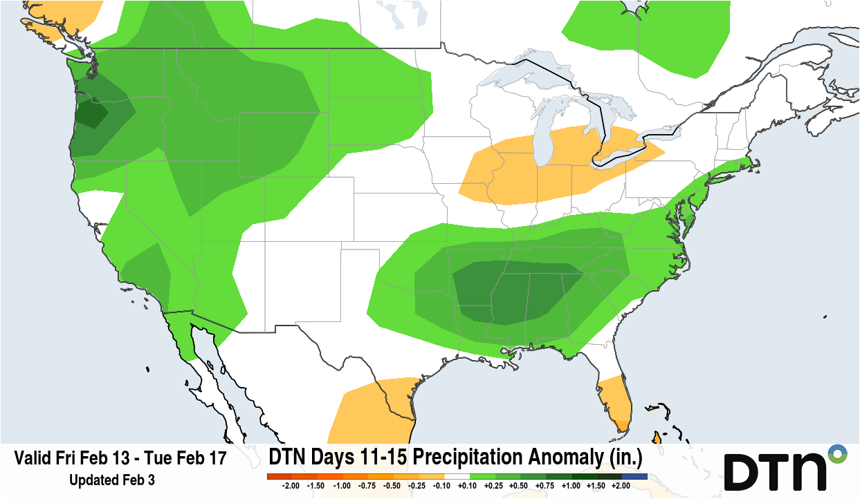
Image: Forecast precipitation anomaly for the February 13-17 period. A more active weather pattern is forecast across most of the country next week, with increased chances for big winter storm systems. Source: DTN.
The upcoming February snow will be different to the big winter storm that occurred in the southern half of the country on January 23-25. Widespread heavy snow and freezing rain caused significant disruptions for two dozen states in the late-January storm. What is different about that setup though, was the preceding arctic air. Any bursts of colder air will now be sourced from the milder Pacific Ocean. The ocean can still bring some shots of colder-than-normal air, but the extreme cold is not likely, leading to more rain-to-snow transitions rather than the rain-to-ice-to-snow sequences seen in late-January.
While next week’s temperatures will not be as frigid as they were in late January, they should still be cold enough to deliver plenty of snow. The Northern and Central Plains through the Midwest and Northeast are most likely to see snow in the coming weeks, although it’s too early to know exactly where snow will fall during mid- to late-February.
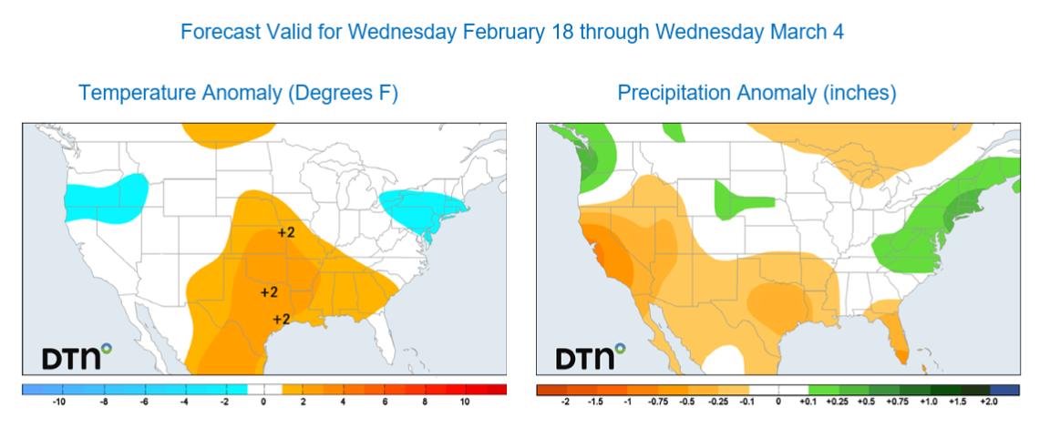
Image: Forecast temperature and precipitation anomaly for the period from February 18 to March 4, 2026. Source: DTN.
The most likely period for big winter storm systems will be mid to late February, roughly from February 10-24, and may extend beyond that into early March. So, while Punxsutawney Phil’s prognostication for an extended winter on Groundhog’s Day might have been wrong about the temperature profile of six more weeks of winter, he could still be right about the precipitation impacts.