
Warmest May on record for Tasmania and Hobart
Tasmania and Hobart just had their warmest May on record based on maximum temperatures, with Victoria and New South Wales also having an exceptionally warm month.
Unusually high pressure over New Zealand in May helped shield Tasmania from cold air and early-season frontal systems. This blocking pattern also caused air to flow over abnormally warm water in the Tasman Sea before reaching Tasmania, further insulating the state from pre-winter cold spells.
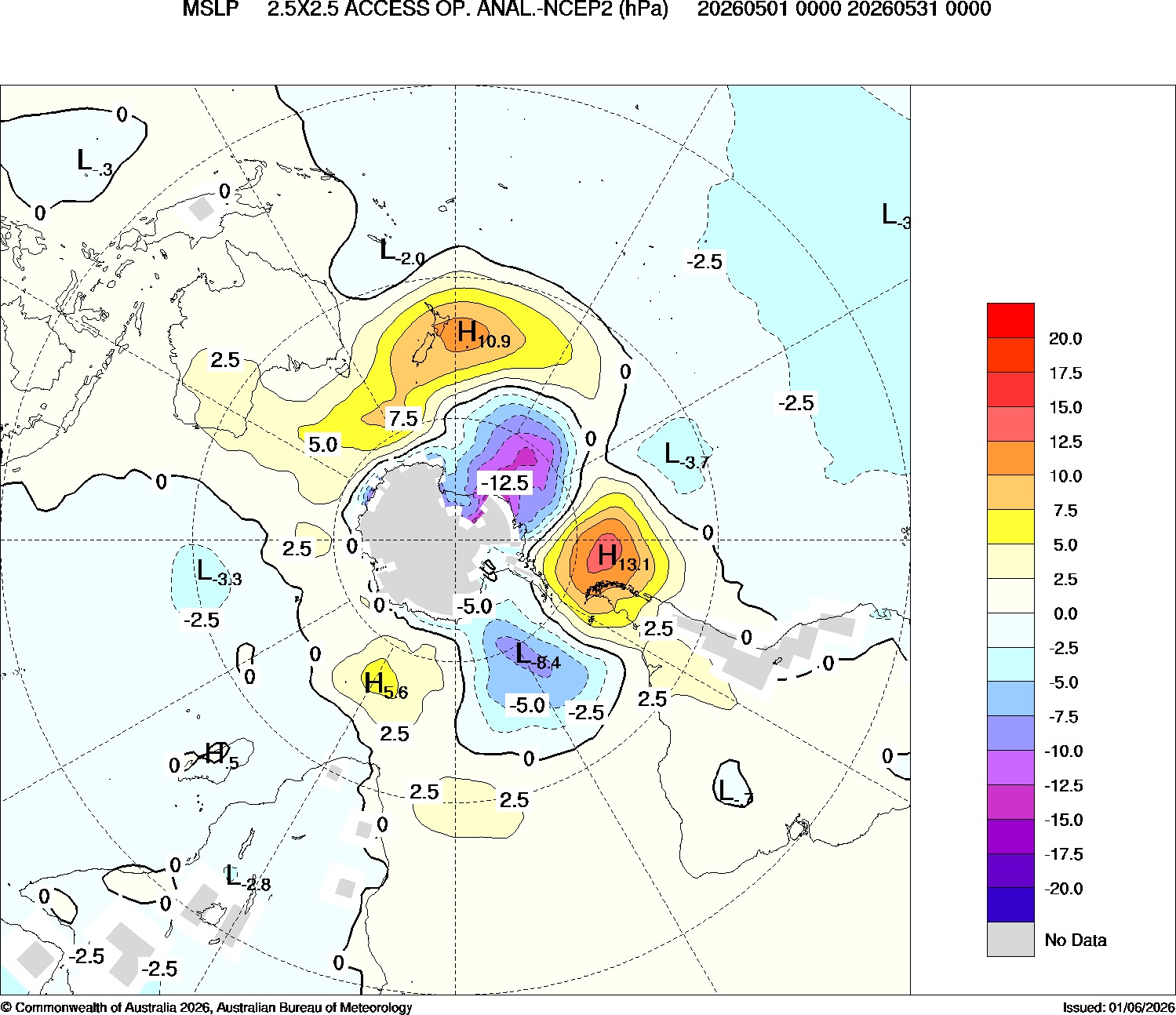
Image: Mean sea level pressure anomalies in the Southern Hemisphere during May 2026. Source: Bureau of Meteorology.
Tasmania’s state-averaged maximum temperature in May was 14.64°C, which was 2.24°C above the 1961-1990 average. The previous record maximum temperature anomaly for Tasmania was +1.87°C from 2007, with data available back to 1910.
Hobart also set a record for daytime warmth last month. The city’s average maximum temperature during May was 17.38°C, beating the previous record of 17.30°C from 2007.
Remarkably, even Hobart's coldest day in May reached 12.1°C – equal to the highest 'coldest day' on record for the month, matched only in 2007.
May also capped off Hobart’s warmest autumn (March to May) on record, with a seasonal average maximum temperature of 19.43°C, beating the old record from 2016 by 0.22°C. Hobart’s maximum temperature data dates back more than 140 years to 1882.
Warm across southeastern Australia
May was an abnormally warm month for large areas of southeastern Australia, particularly when combining both minimum and maximum temperatures.
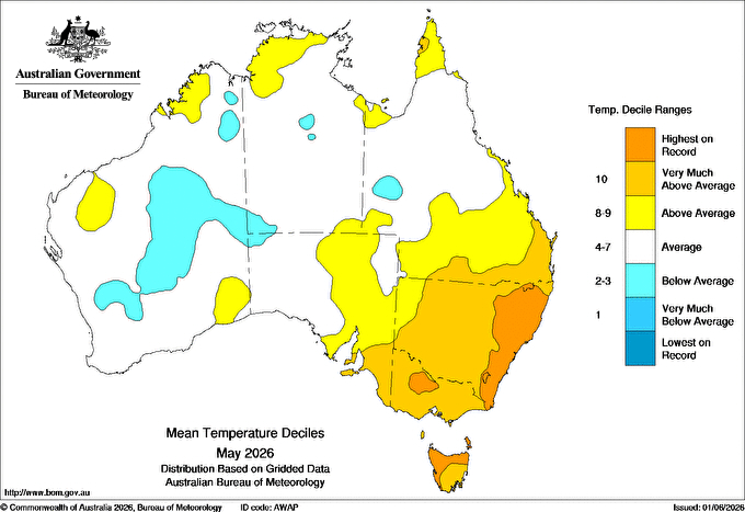
Image: Mean temperature deciles across Australia in May 2026. Source: Bureau of Meteorology.
Victoria and New South Wales both registered their second warmest Mays on record based on mean temperatures, with anomalies of +1.87°C and +2.04°C, respectively. These were only beaten by 2007.
Sydney had its second warmest May on record based on mean temperature, with an average of 18.19°C for the month. This was only just behind the record of 18.22°C from 1958. The city’s average minimum temperature of 14.51°C in May 2026 was a new record by more than half a degree. Sydney’s temperature observations date back more than 160 years to 1859.
How does this May fit into longer-term trends?
Mays have been getting warmer across southeastern Australia in recent decades. According to data from the Bureau of Meteorology, the mean May temperature in southeastern Australia has increased by around 0.11°C per decade during the last 117 years, equivalent to almost 1.3°C of warming between 1910 and 2026.
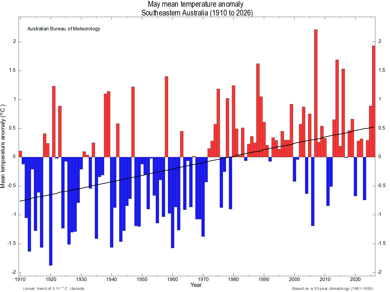
Image: Long-term May mean temperature trend for southeastern Australia. Source: Bureau of Meteorology.
This warming trend is likely to have contributed to the record-breaking temperatures seen in parts of southeastern Australia during May 2026. However, it was not the only factor, with local weather patterns also playing a big part in making last month so warm.