
Warm water building beneath Pacific Ocean surface raises prospect of El Niño for Australia in 2026
A large pool of abnormally warm water sitting below the surface of the tropical Pacific Ocean is starting to emerge at the surface, rapidly tipping the scales towards El Niño.
El Niño is characterised by warmer-than-average sea surface temperatures in the central and eastern tropical Pacific Ocean. When this oceanic El Niño pattern becomes established, it typically influences the overlying atmosphere and affects weather patterns on a global scale.
Read more: What does a 'super El Niño' mean for Australia’s weather?
Scientists monitor sea surface temperatures in two key regions of the tropical Pacific Ocean when tracking El Niño:
- The Niño 3.4 region – in the central equatorial Pacific bounded by latitudes 5°N to 5°S and longitudes from 170°W to 120°W.
- The Niño 3 region – in the eastern equatorial Pacific bounded by latitudes 5°N to 5°S and longitudes from 150°W to 90°W.
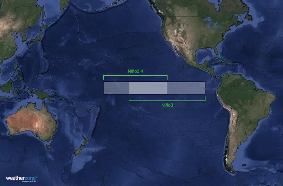
Image: The Niño3.4 and Niño3 regions in the tropical Pacific Ocean. Source: Weatherzone.
In addition to tracking sea surface temperatures at the surface of the Pacific Ocean, it is also important to watch what’s happening below the surface in the top few hundred metres of the tropical Pacific.
The Bureau of Meteorology points out that “cooler than average waters beneath the surface of the central and eastern tropical Pacific can be a sign of La Niña development, while warmer than average waters can be a sign of El Niño development.”
Warm water looming beneath the surface
Water temperatures beneath the surface of the tropical Pacific Ocean are currently exceptionally warm for this time of year. In some places, the subsurface temperatures are running more than 6°C above the long-term average for this time of year.
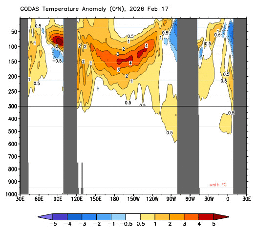
Image: Evolution of water temperature anomalies below the surface of the equatorial Pacific Ocean during the last three months, showing a large blob of abnormally warm water extending from around 150 m depth towards the surface in the eastern Pacific. Source: NOAA/CPC.
This massive slab of warm subsurface water has started spreading towards the surface in the eastern tropical Pacific Ocean in recent weeks. This emerging warm deep water has been causing sea surface temperature anomalies to rise rapidly in the central and eastern tropical Pacific, particularly in the Niño3 region.
According to data on the Bureau of Meteorology’s website, the Relative Niño3 index rose to +1.07°C during the week ending on May 17. This was the first time in more than two years the Niño3 index has exceeded the Australian El Niño threshold of +0.8°C.
Water temperatures have also risen rapidly in the Niño3.4 region in recent weeks, with anomalies climbing from -0.06°C in mid-April to +0.68°C in mid-May. It’s now close to the Australian El Niño threshold of +0.8°C.
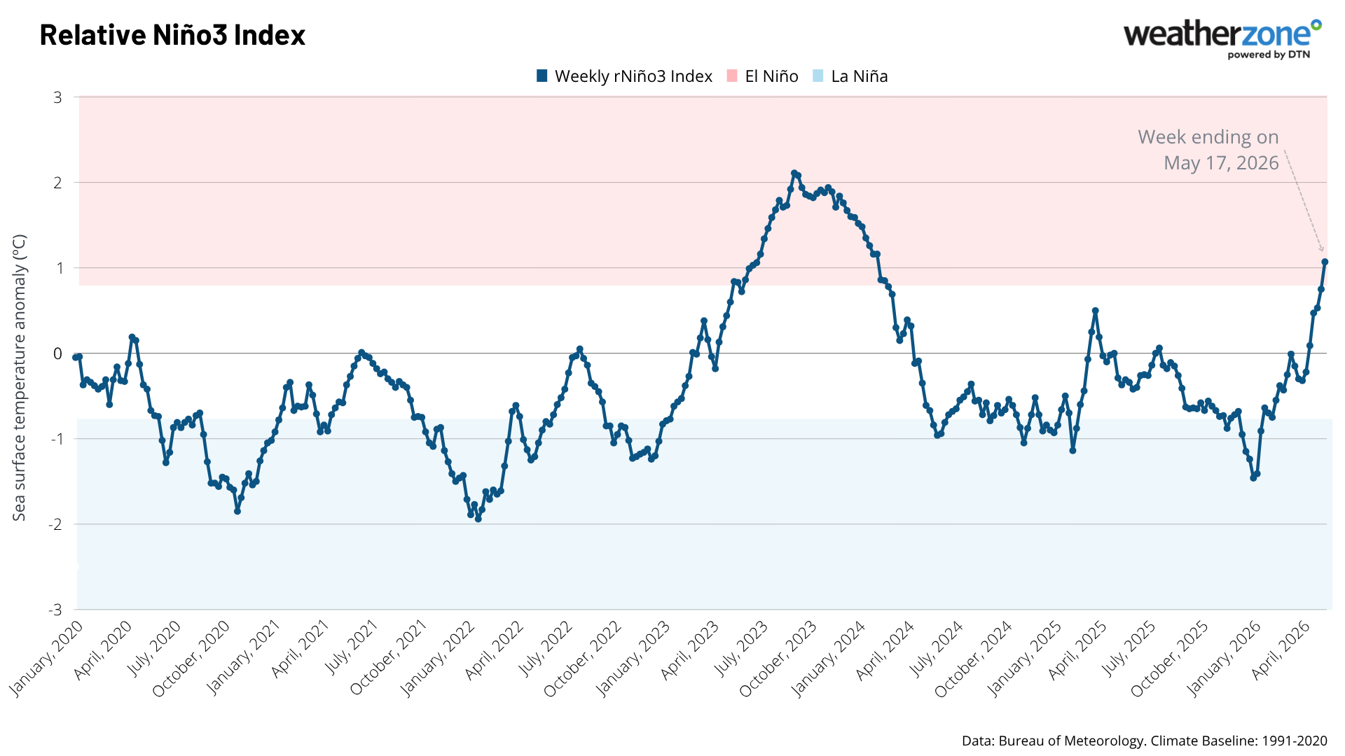
Image: Weekly Relative Niño3 index values since 2020, showing the emergence of this year’s El Niño signal in recent weeks. Source: Weatherzone.
It’s worth noting that for El Niño to be declared by the Bureau of Meteorology, sea surface temperature anomalies in the Niño3 or Niño3.4 regions need to exceed +0.8°C for a sustained period (several consecutive months), along with a reinforced atmospheric response over the tropical Pacific Ocean.
The recent emergence of El Niño values in the tropical Pacific Ocean is not yet enough to qualify as a fully-fledged El Niño. However, with so much warm water still lurking beneath the surface, it’s likely that the oceanic El Niño signal will continue to strengthen in the coming months.
Modelling from the European Centre for Medium Range Weather Forecasts (ECMWF) shows that sea surface temperature anomalies in the tropical Pacific are indeed expected to increase further in the Southern Hemisphere's winter and spring. The maps below show the forecast anomalies in the Niño3 and Niño3.4 regions in June and October this year, with a clear warming trend over this four-month period.
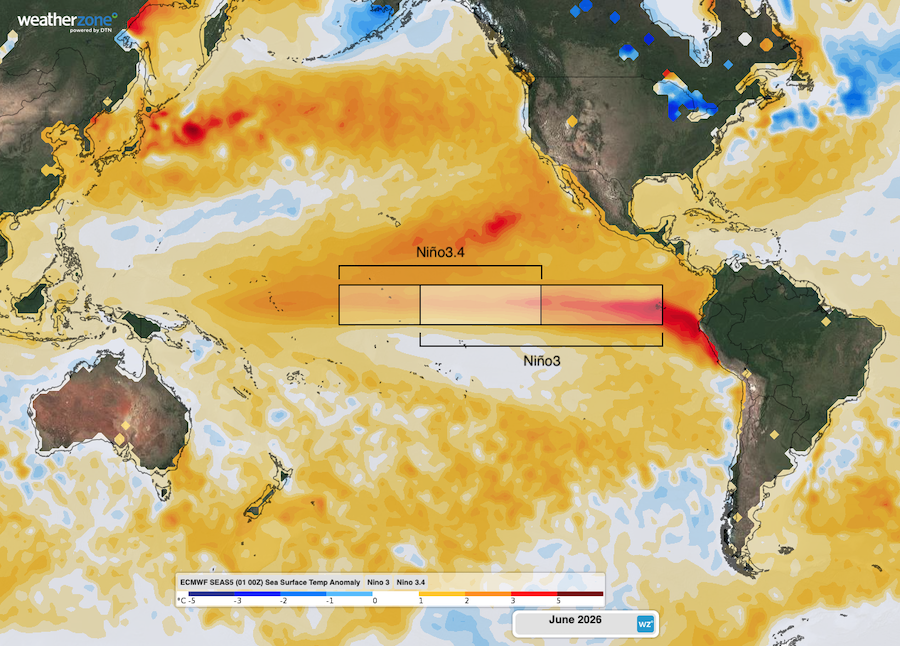
Image: Forecast sea surface temperature anomalies in the Pacific Ocean in June 2026, according to the ECMWF SEAS5 model. Source: Weatherzone.
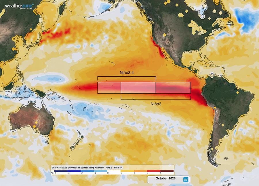
Image: Forecast sea surface temperature anomalies in the Pacific Ocean in October 2026, according to the ECMWF SEAS5 model. Source: Weatherzone.
This outlook of a strengthening El Niño is backed up by forecasts from the Bureau of Meteorology, which predict that relative sea surface temperature anomalies in the Niño3 region will reach +3.8°C by October. If this does happen, it would be the highest monthly Niño3 value in records dating back to 1900. However, it’s worth noting that forecasts at 5-month lead time carry considerable uncertainty.
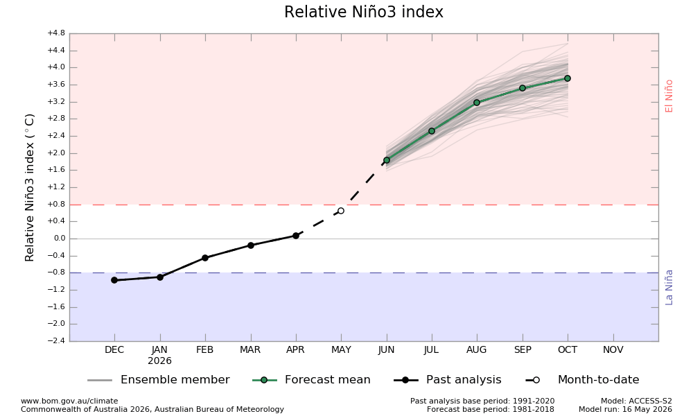
Image: Niño3 forecast from the Bureau of Meteorology’s ACCESS-S model. Source: Bureau of Meteorology.
What does this mean for Australian weather?
With El Niño likely to form in 2026 and a very strong or ‘super’ El Niño possible, certain types of weather will have an increased likelihood of occurring in Australia during the months and seasons ahead:
- Below average rainfall over large areas of Australia during winter and spring, particularly in the eastern half of the country.
- Above average maximum temperatures for most areas outside the tropics, particularly during the second half of the year.
- In the tropics, El Niño typically reduces maximum temperatures during the dry season and makes days warmer-than-average in the wet season.
- Enhanced evaporation due to above average temperatures and below average rainfall, which can cause or enhance drought.
- More intense daily heat extremes in southern Australia during the warmer half of the year, but with a reduced frequency of prolonged heatwaves.
- Increased frost risk in winter and spring due to enhanced radiative cooling with clearer skies.
- Increased risk of dangerous fire days in southeastern Australia in the spring and summer following an El Niño year.
- Decreased seasonal peak alpine snow depths and a shorter snow season.
However, it is important to note that no two El Niño events are the same and the influence on Australian weather can also vary a lot between events. Other influences, such as the Indian Ocean Dipole, the Southern Annular Mode and sea surface temperatures near Australia can either enhance or counteract the influence of El Niño.
Stay up to date with the latest long-range forecasts to see how the developing El Niño is expected to influence Australia's weather in the coming months. These forecasts are available from Weatherzone and the Bureau of Meteorology websites.