
WA to face heatwave and flooding at the same time
Western Australia will be hit by a severe heatwave and flooding rain during the coming days, with Perth in line for a sweaty start to February.
A persistent high pressure ridge to the south of Western Australia will interact with a tropical low near the state's north during the next several days. This synoptic pattern will cause hot easterly winds to flow towards the state's western coastline, while heavy rain falls in the north, near the tropical low.
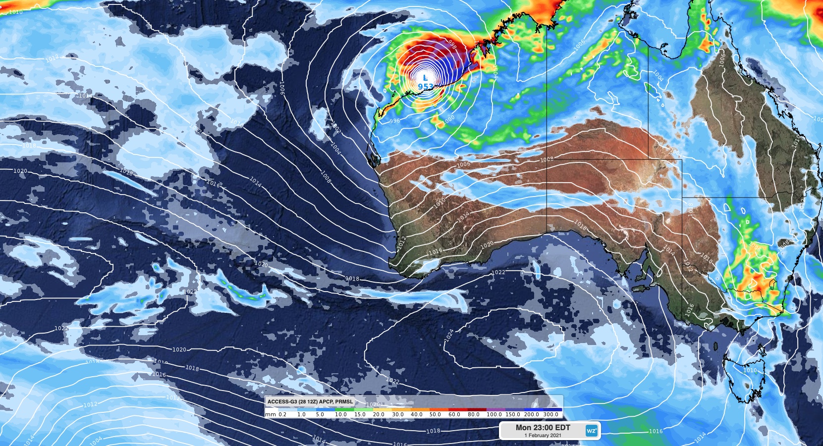
Image: Forecast accumulated 24-hours rainfall and mean sea level pressure on Monday night, according to the ACCESS-G model. A large high pressure system can be seen to the south of WA, while a deep low or tropical cyclone sits near the state's north coast.
-- Heatwave --
Persistently above-average temperatures will cause a severe heatwave along parts of the state's west coast between now and at least the middle of next week.
Perth is forecast to reach 36-37ºC from this Sunday until next Wednesday. This heat should see the city round out its hottest January in five years based on daytime maximum temperatures.
The city is also forecast to see tops of 37ºC during the first three days of February, which would be Perth's hottest trio of February days for five years.
Unsurprisingly the impending heatwave will cause a spike in fire danger ratings along the state's west coast too.
Severe fire danger ratings are likely for the Exmouth Gulf Coast, Gascoyne Coast and Coastal Central West - North districts today (Friday). Severe to Extreme fire danger ratings could become more widespread in the state's west early next week as wind strengthens over the region.
-- Tropical soaking --
While hot weather grips western districts of Western Australia over the next several days, heavy rain will cause flooding in the north.
A tropical low that's currently located over the Kimberley is expected to move slowly towards the west southwest today and into the weekend. This system will cause heavy rain over parts of the Kimberley, where a flood watch and severe weather warning have been issued.
Heavy rain could also spread into the Pilbara either this weekend or early next week as the low moves further west.
At this stage, it's uncertain whether the low will remain over land or move out to sea as it travels towards the west. Some models suggest that it could move off the coast near Broome on Sunday, while others keep it over land into the beginning of next week.
If it does venture over open water, the low would be likely to gain strength and could become a tropical cyclone. However if it stays over land, it won't become a tropical cyclone.
At 9am WST, a Cyclone watch was in place for the coast and adjacent inland between Cape Leveque to Pardoo.
Anyone living in the Kimberley or Pilbara should closely monitor this developing typical low during the coming week.