
Vast area of booming outback storms
A dynamic few days of Australian weather has kicked off with thunderstorms and wild wind gusts across a huge part of the country’s interior.
Numerous outback locations in three states and the Northern Territory saw thunderstorms with heavy rainfall from Monday afternoon through to Tuesday morning. Notable 24-hour totals to 9am Monday totals included:
- Alice Springs received 21.4mm, which was its heaviest daily fall in September for 32 years. September is typically the second-driest month, with a monthly average of just 8.6mm. Some storm damage from wind gusts was also reported.
- Tibooburra in the far northwest corner of NSW received 31.6mm. Unusually for this very dry outpost, this was the second-highest 24-hour daily rainfall total anywhere in NSW.
- Moomba Airport in the far northeast corner of SA received 15mm, which was by far the highest 24-hour total yesterday at any South Australian weather station.
- Just over the border from Moomba, several spots in southwest Qld received heavy falls for this time of year, including 20mm at Nappa Merrie cattle station.
The iconic outback town of Birdsville was another location in southwest Qld to receive a decent drop. While its 24-hour total of 9.6mm wasn’t huge, it was still more rain in a day than the entire September monthly average of 8.8mm. Roads in the Cameron Corner area (where NSW, SA and Qld meet) have been closed due to flooding.
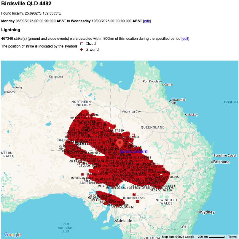
Image: Lightning strikes within 800km of Birdsville in the 36 hours to midday on Tuesday, September 9, 2025.
Birdsville’s weather was also notable for lightning (with 467,000 strikes detected within 800km of the town in the 36 hours to midday Turesday) as well as for several wild wind gusts which reached 117 km/h early on Monday evening as the storms blew into town.
Fortunately, most of the 4,000 visitors who camped last weekend for the town's annual Birdsville Races had already packed up their tents.
Why such dynamic weather in the outback?
Weatherzone meteorologist Joel Pippard pointed to the combination of heat plus a northwest cloudband streaming across the continent bearing tropical moisture.
"Heat plus moisture equals thunderstorms, it’s that simple," Pippard said.
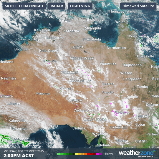
Image: Combined radar and satellite loop in the interior of Australia on the afternoon of Monday, September 8, 2025. The pink blobs indicate outbreaks of lightning associated with storms.
Pippard added that storms were occurring even at 5am this Tuesday at some outback locations – a time of day when the weather is typically benign in early spring.
Meanwhile the likelihood of storms will increase this Tuesday afternoon in parts of southern Qld and large parts of NSW, roughly along the line of the northwest cloudband.
A stormy outbreak is also likely in parts of Victoria and southern SA in coming days, as polar air in the Southern Ocean clashes with warmer air.
If you look closely at the satellite and radar loop above, you can see the airmass with polar origins surging onto the WA coast near Esperance. Expect dynamic weather as that airmass pushes east.