
Update: Heavy rain drenching South Australia and Victoria, and much more to come
The low pressure system over the country’s interior has been slowly moving southward, as stated in Anthony Sharwood’s story, leading to increased heavy falls over South Australia and Victoria. Flooding rainfall persists over South Australia, with a severe weather warning active for every district in the state. Yesterday the heaviest falls were recorded in the state’s west, with 24-hour totals recorded and estimated to have reached:
- 180mm at Ooldea (midday Fri 27th to midday Sat 28th)
- 124mm at Perlubie
- 120mm at Wirrulla
- 112mm at Mundamuckla
- 101mm at Gawler Ranges
- 100mm at Maralinga
In the 24 hours to 9am this morning (28th February) South Australia saw:
- 103mm in Minnipa (and a further 25mm+ from 9am)
- 75.2mm in Ceduna (and a further 30mm+ from 9am)
- 69.0mm in Wudinna (and a further 15mm+ from 9am)
- 45.4mm in Parndana
- 33.0mm in Rayville
- 31.0mm in Woomera
For many places in the state's west, it's been the heaviest rain in several years, decades in some places.
Victoria also experienced heavy falls yesterday. Some cities in western Victoria saw the heaviest rainfall in the 24 hours on February 27th than they had seen in the last 3-8 years, if not the highest February falls in a decade! Some of these cities include:
- Horsham saw 96.4mm in 24 hours. The heaviest fall on record for the city (where the record starts at 1998). Of this 96.4mm, approximately 91.0mm of it fell in one hour!
- Longerenong saw 52.6mm in 24 hours. The heaviest fall since November 2018, and heaviest February rain since 1973
- Warracknabeal saw 47.8mm in 24 hours. The heaviest fall since January 2022
- Edenhope saw 32.4mm in 24 hours. The heaviest fall since November 2023, and heaviest February rain since 2020
- Kilmore Gap saw 24.4mm in 24 hours. The heaviest February rain since 2013
- Latrobe Valley saw 30.2mm in 24 hours. The heaviest February rain since 2015
- Charlton saw 27.2mm in 24 hours. The heaviest February rain since 2016
Rainfall is expected to persist over South Australia this weekend, slowly moving into Victoria and western NSW on Monday as a front pushes the weakening low eastward. The heaviest rainfall is expected with thunderstorms, as southeast South Australia experienced this morning; more than 110,000 lightning strikes in the 300km around Mount Gambier Saturday 28th morning and 10 to 30mm of rainfall per location in the vicinity. A severe weather warning was issued for these thunderstorms by the Bureau of Meteorology for this morning.
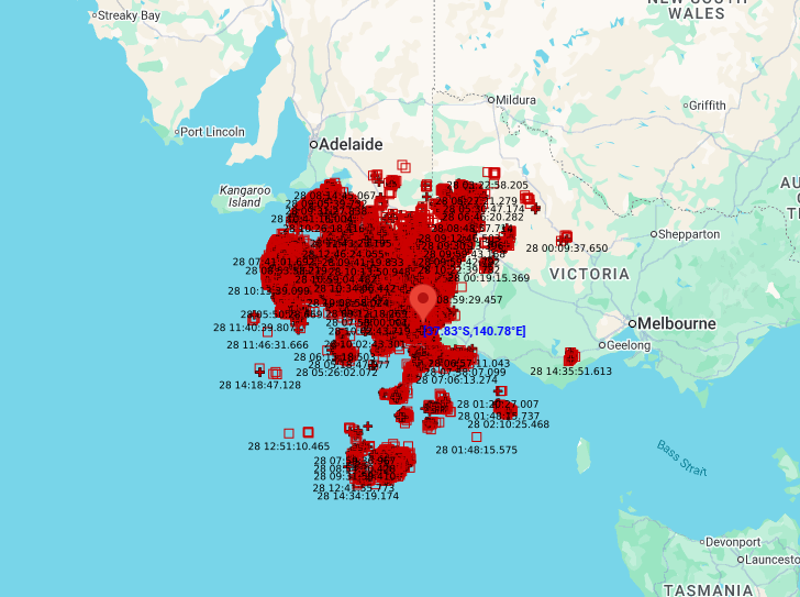
Image: Radar detected lightning strikes within a 300km radius of Mount Gambier
Daily rainfall totals exceeding 100mm can be expected for SA over the weekend, with similar rates possible in Victoria on Monday.
The Bureau of Meteorology has issued severe weather and flood warnings for South Australia, western Victoria and southwest New South Wales today, which are likely to be extended for Sunday and Monday at the very least.