
Unseasonable rain floods part of Australia's west and east
Australia's interior and north are typically dry at this time of year but some of WA, Queensland and New South Wales have just been flooded by unseasonably heavy rain.
There have been two distinct areas of significant rain, one in the west and another in the east, separated by thousands of kilometres of dry.
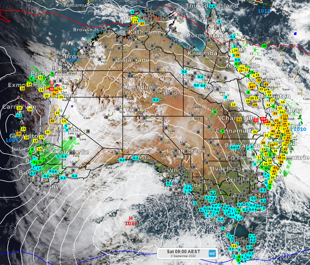
Image: Visible satellite image, radar and rainfall observations at 9am on Saturday, September 3.
Slow-moving low-pressure troughs fuelled by tropical moisture have been the cause of these two rain areas.
Recent rain across Queensland and northern NSW has been the heaviest in 2-4 months in many areas, 10 months at Birdsville (it's 24mm was enough for the first day of races to be cancelled https://www.weatherzone.com.au/news/birdsville-races-given-the-hook-due-to-rain/784983) and 9 months at Roma (51mm in 24 hours).
It’s unusually wet for this time of year, the heaviest September rain in 56 years at Injune (45mm in 24 hours), 25 years at Warwick (42mm in 48 hours), 24 years at Dalby (37mm in 24 hours) and Toowoomba (23mm in 24 hours), 16 years at Lismore (45mm in 48 hours), 14 years at Surat (34mm in 24 hours) and Nambour (40mm in 24 hours) and 12 years at Tewantin (50mm in 48 hours), Logan (22mm in 48 hours) and Gympie (37mm) and 11 years at Taree (35mm).
In WA, dust turned to mud in the Gascoyne and Pilbara with help from Indian Ocean moisture feeding a low.
The past 24 hours (to 9am Saturday) have brought the heaviest rain in 3.5 years at Coodardy (35mm), 2.5 years at Bryah (35mm), Beebyn (32mm), 1.5 years at Barimunya (54mm), Winderie (42mm), Karijini (60mm) and Newman (33mm) and 15 months at Meekatharra (32mm).
How unseasonable was it? Very. It was the heaviest September rain in more than 110 years at Murgoo (37mm), 98 years at Beebyn, more than 90 years at Bulloo Downs (31mm) and Doolgunna (28mm), more than 80 years at Carey Downs (34mm), more than 70 years at Meekatharra (32mm) and 52 years at Onslow (14mm).
Both of these rain systems are now dying, causing rain to clear from most areas. However, the NSW north coast can expect some heavy downpours between now and Sunday morning as a low-pressure system intensifies offshore. This low will also generate damaging winds and surf.
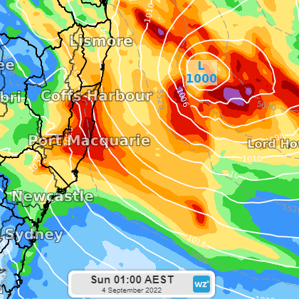
Image: forecast low pressure system and 24-hour rainfall and to Sunday morning September 4.
Be sure to check the latest warnings as this weather event unfolds.
Thankfully, flooding in both the west and east of the country has largely only been minor but it does add to soil saturation, making the next big rain event more problematic.