
Twin cyclones in the South Pacific: how will they impact Australia and New Zealand?
Two severe tropical cyclones are the dominant features on the weather charts this Tuesday, with both Cyclone Maila (currently near Papua New Guinea) and Cyclone Vaianu (currently near Fiji) set to impact weather in the Australian region.
Let’s take a closer look at the two systems and their potential impacts.
Cyclone Maila
At 10am (AEST) this Tuesday, Cyclone Maila was located in the Solomon Sea, between the Solomon Islands and eastern Papua New Guinea.
The relatively slow-moving severe category 3 system is projected to impact the far southeastern tip of PNG by Friday morning. It’s then expected to move towards the Far North Queensland coast by the weekend, potentially making landfall over the weekend or early next week.
At this stage, it is not known how strong the cyclone is likely to be if and when it crosses the Australian coastline.
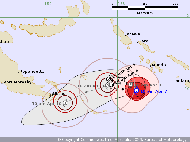
Image: Cyclone Maila’s projected track for the next three days. Source: BoM.
Why PNG rarely sees cyclones
Because of its proximity to the equator, Papua New Guinea sees very few cyclones.
The reason cyclones don’t form at the equator is because of the Coriolis Force (the force, caused by the spinning Earth, which makes air, water and projectiles curve).
The Coriolis Force is zero at the equator and weak in nearby latitudes, meaning low pressure systems can’t develop sufficient rotation to become cyclones. But Maila formed in waters east of PNG, just far enough south to gain cyclonic strength. The PNG Weather Service named it as it formed in their jurisdiction.
Cyclone Vaianu
Tropical Cyclone Vaianu formed near Fiji and was named by the Fiji Meteorological Service.
It is currently a category 3 severe tropical cyclone and is causing heavy rain and strong winds as it passes west of Fiji and east of Vanuatu, without making landfall in either nation.
Vaianu is expected to track south during the week, more or less making a beeline towards the North Island of New Zealand.
While it will no longer be a tropical cyclone, it is likely to hit Auckland and nearby areas during the weekend as an "extratropical cyclone", a type of system which can pack as much strength as a category 2 or 3 cyclone in terms of its central pressure and wind speeds.
The NZ Met Service currently has no warnings in place for this system, however this is likely to change as the week rolls on.
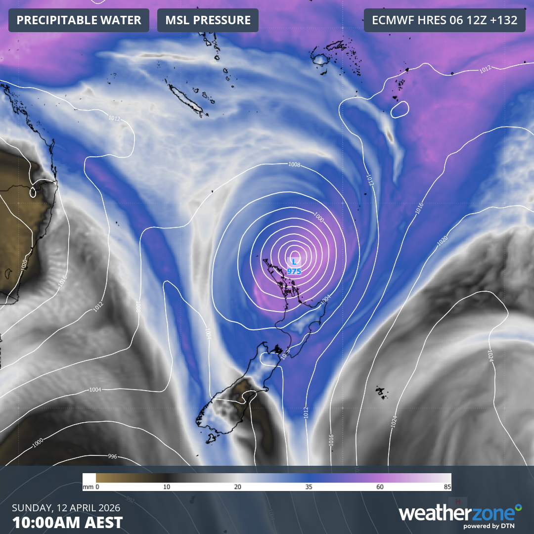
Image: Mean sea level pressure and precipitable water expected for the New Zealand region on Sunday, April 12, 2026, according to the ECMWF model. Source: Weatherzone.
How rare are tropical cyclones in the Australian region in April?
The Australian tropical cyclone season runs from November 1 to April 30.
As the graph below shows, the number of cyclones in the Australian region drops off to an average of 1.4 in April (the light blue line).
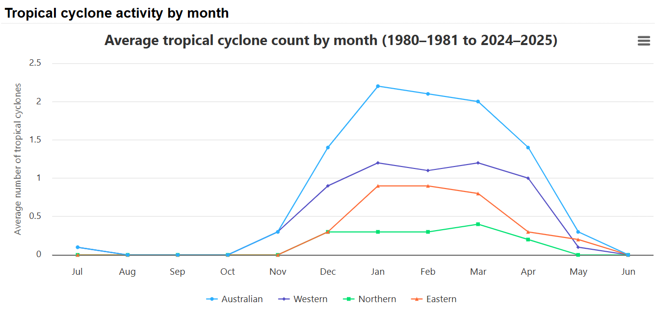
Image: Historical tropical cyclone activity by month in the Australian region. Source: BoM.
Early indications are that one and possibly two more cyclones could form in northern Australian waters this week, most likely off the Northern Territory and Western Australia. We'll keep you posted.