
Twin cyclones fuelling widespread rain

Moisture from two tropical cyclones will cause widespread rain and thunderstorms across central and eastern Australia this week.
Tropical Cyclones Trevor and Veronica both affected northern Australia on the weekend.
Trevor made landfall over the southwest Gulf of Carpentaria on Saturday and was tracking across the NT as a low pressure system on Monday, towards central Australia.
Further west, Veronica stalled near WA's Pilbara coast on Sunday and was still lingering just offshore between Port Hedland and Karratha on Monday morning.
Moisture from the pair of tropical systems has been spreading across Australia during the last couple of days, bringing some welcome rain to the nation's south.
In South Australia, 10-30mm of rain fell in the Flinders and lower Pastoral districts during the 24 hours to 9am on Monday. Roxby Downs picked up 13mm, which was its heaviest rain in two years. Moomba's 12mm was their best rain in 12 months.
Further east, alpine areas Victoria and NSW received 20-40mm on Sunday, with a few places picking up more than 50mm. Thredbo's 72mm of rain during the 24 hours to 9am on Monday was its heaviest rain in more than a year. Mt Hotham's 116mm was their heaviest March rain on record.
The combined moisture from Veronica and Trevor is now moving further east, where it will cause widespread rain and storms in Queensland and NSW this week.
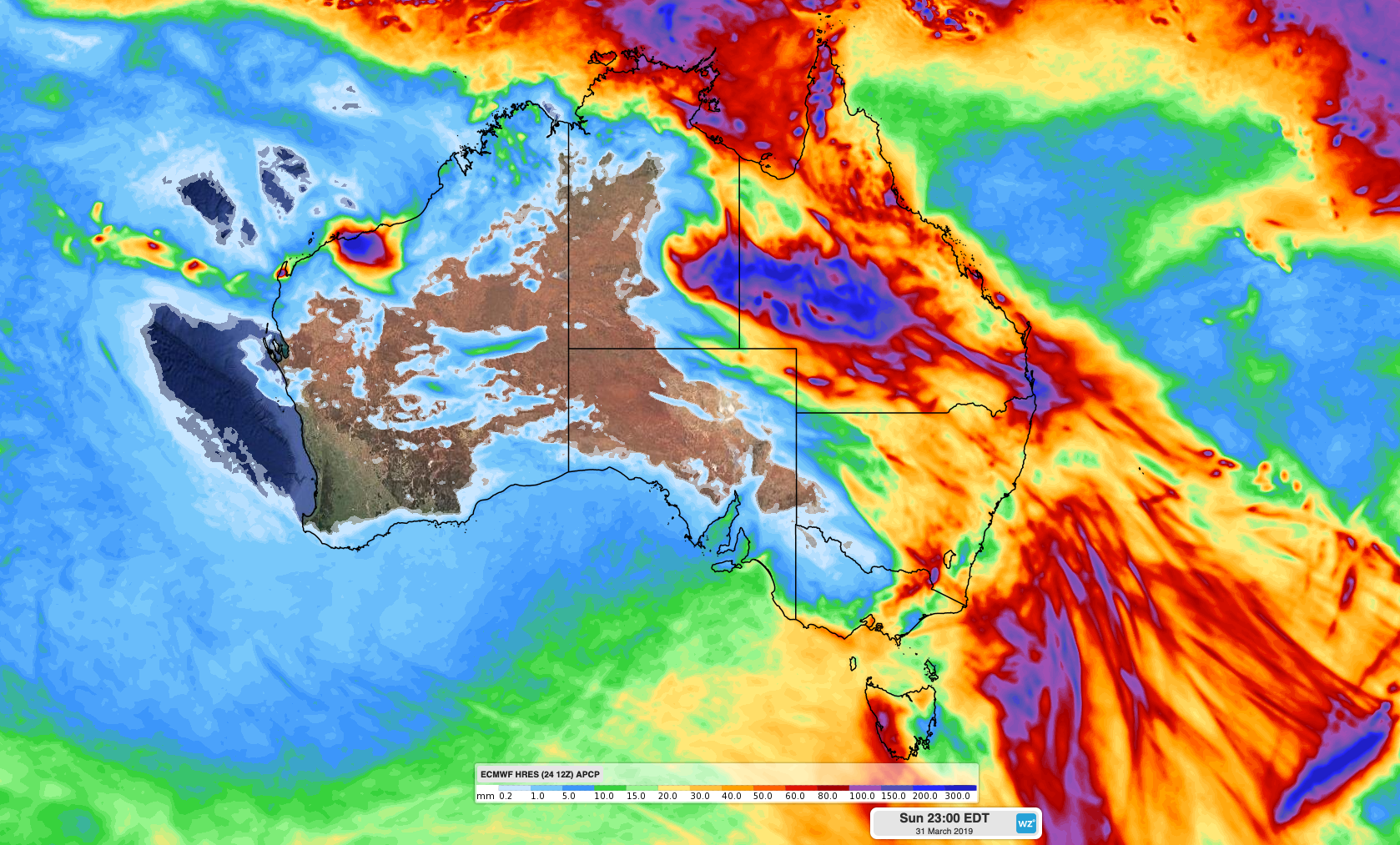
Image: Forecast accumulated rain this week, according to the ECMWF-HRES model.
The heaviest rain during the coming days will occur near Ex-Tropical Cyclone Trevor, which is expected to track across Queensland's western and southern interior. Some models suggest that more than 200mm of rain could accumulate as Trevor's remnants pass over inland Queensland between now and Thursday.
Flood watches have been issued in the state's western Gulf Country, Channel Country and parts of the Warrego and Maranoa catchments. A severe weather warning was also in place for the state's southwest on Monday morning for heavy rain and possibly destructive winds during the next 24 hours.
Showers and storms will also affect a broad area of eastern and northern Queensland and NSW this week.
Rainfall totals in NSW this week will generally be lighter than those seen in western Queensland, although some areas should pick up 20-40mm by Sunday, possibly more with severe storms.
Severe weather is likely in eastern Australia each day this week, so be sure to keep up to date with the latest warnings and forecasts.