
Twin atmospheric rivers behind the flooding rain in NSW
Weekly rainfall totals in easern NSW are approaching one metre as a relentless spell of wet weather continues to inundate flooded rivers and overflowing dams.
The combined influence of two atmospheric rivers are causing a six-day deluge in eastern NSW, which started last Thursday and will continue until Tuesday.
Atmospheric rivers are concentrated corridors of moisture-laden air that transport huge amounts of water across our planet. In this case, NSW is being hit by one atmospheric river from the east and another from the northwest.
Two streams of atmospheric moisture converge over eastern NSW. pic.twitter.com/S9gOeccdci
— Andrew Miskelly (@andrewmiskelly) March 21, 2021
These twin atmospheric rivers could deliver one metre of rain to parts of eastern NSW by the end of this event.
Some places along the state's Mid North Coast have already collected close to 900mm of rain during the last four days. Some rain gauges near Sydney have picked up over 400mm since Thursday.
The biggest multi-day totals up to 9am on Monday were near Port Macquarie. A gauge at Comboyne Public School registered 853mm during the 96 hours to 9am Monday. This four-day soaking brought their total over the last 7 days up to 890mm.
Other notable totals during the last four days were 825mm at Redoak and 713mm at Mount Seaview.
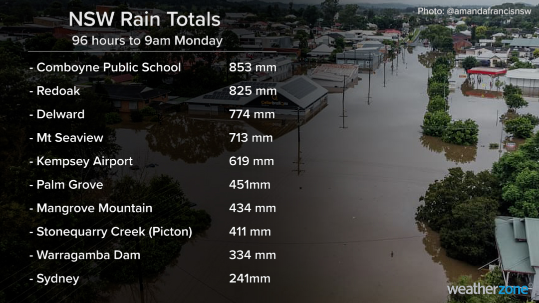
Image: Some of the notable four day rainfall totals observed in NSW during the 96 hours to 9am on Monday.
Closer to Sydney, some of the heaviest rain during the four days to 9am on Monday included 451mm at Palm Grove, 434mm at Mangrove Mountain and 411mm at Picton's Stonequarry Creek.
Some rain gauges in the Warragamba Dam catchment area also collected over 300mm during the last four days.
Many of the heaviest totals over the last four days are about 3-5 times the monthly averages at this time of year.
For more perspective on how wet the past few days have been, the long-term annual averages in Sydney and Melbourne are 1213.4mm and 648.3mm respectively.
The sustained stream of atmospheric moisture will see more widespread rain falling over NSW on Monday and Tuesday. Some flooded areas in the state's east could see another 50-100mm across these two days, which could cause further river level rises.
Make sure you stay up-to-date with the latest evacuation orders and flood warnings if you live in NSW.